Conn Paul B, Moreland Erin E, Regehr Eric V, Richmond Erin L, Cameron Michael F, Boveng Peter L
Alaska Fisheries Science Center , National Marine Fisheries Service, NOAA , 7600 Sand Point Way NE, Seattle, WA 98115, USA.
US Fish and Wildlife Service , Marine Mammals Management , 1011 East Tudor Road, Anchorage, AK 99503, USA.
R Soc Open Sci. 2016 Jan 27;3(1):150561. doi: 10.1098/rsos.150561. eCollection 2016 Jan.
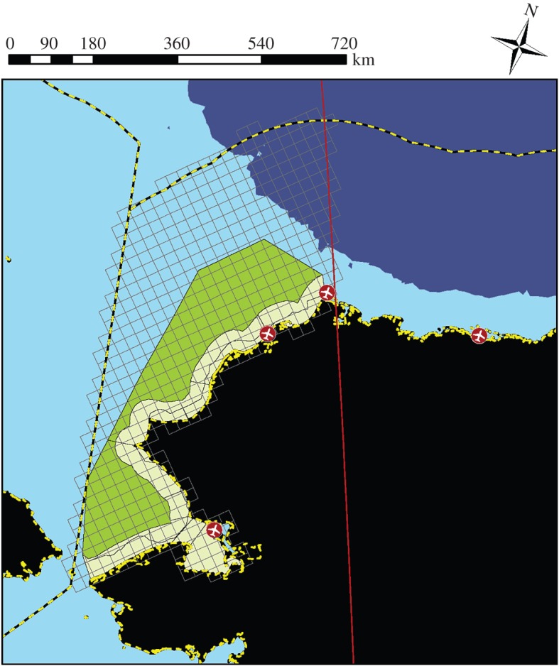
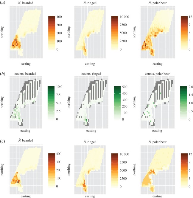
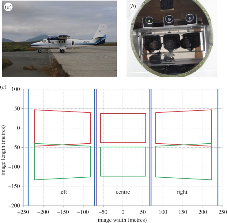
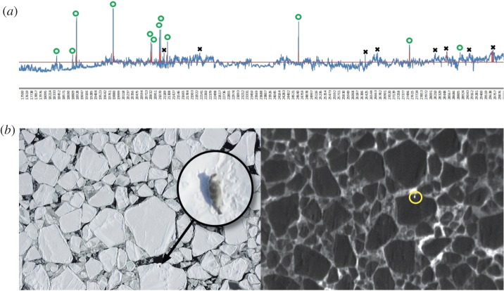
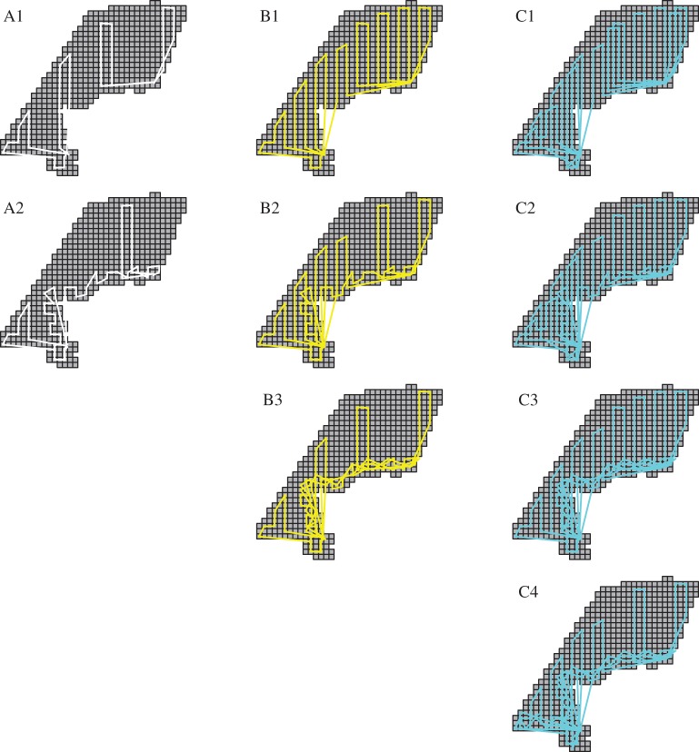
Logistically demanding and expensive wildlife surveys should ideally yield defensible estimates. Here, we show how simulation can be used to evaluate alternative survey designs for estimating wildlife abundance. Specifically, we evaluate the potential of instrument-based aerial surveys (combining infrared imagery with high-resolution digital photography to detect and identify species) for estimating abundance of polar bears and seals in the Chukchi Sea. We investigate the consequences of different levels of survey effort, flight track allocation and model configuration on bias and precision of abundance estimators. For bearded seals (0.07 animals km(-2)) and ringed seals (1.29 animals km(-2)), we find that eight flights traversing ≈7840 km are sufficient to achieve target precision levels (coefficient of variation (CV)<20%) for a 2.94×10(5) km(2) study area. For polar bears (provisionally, 0.003 animals km(-2)), 12 flights traversing ≈11 760 km resulted in CVs ranging from 28 to 35%. Estimators were relatively unbiased with similar precision over different flight track allocation strategies and estimation models, although some combinations had superior performance. These findings suggest that instrument-based aerial surveys may provide a viable means for monitoring seal and polar bear populations on the surface of the sea ice over large Arctic regions. More broadly, our simulation-based approach to evaluating survey designs can serve as a template for biologists designing their own surveys.
从后勤角度来看要求高且成本高昂的野生动物调查,理想情况下应能得出可靠的估计值。在此,我们展示了如何利用模拟来评估用于估计野生动物数量的替代调查设计。具体而言,我们评估了基于仪器的航空调查(将红外图像与高分辨率数码摄影相结合以检测和识别物种)在估计楚科奇海北极熊和海豹数量方面的潜力。我们研究了不同调查力度、飞行轨迹分配和模型配置水平对数量估计器偏差和精度的影响。对于髯海豹(0.07只动物/平方公里)和环斑海豹(1.29只动物/平方公里),我们发现对于一个2.94×10⁵平方公里的研究区域,八次飞行穿越约7840公里足以达到目标精度水平(变异系数(CV)<20%)。对于北极熊(暂定为0.003只动物/平方公里),十二次飞行穿越约11760公里导致CV值在28%至35%之间。尽管某些组合表现更优,但在不同飞行轨迹分配策略和估计模型下,估计器相对无偏且精度相似。这些发现表明,基于仪器的航空调查可能为监测北极大片区域海冰表面的海豹和北极熊种群提供一种可行的方法。更广泛地说,我们基于模拟评估调查设计的方法可作为生物学家设计自己调查的模板。