NASA Goddard Space Flight Center, Cryospheric Sciences Laboratory, Greenbelt, Maryland, 20771, USA.
Oregon State University, College of Earth, Ocean, and Atmospheric Sciences, Corvallis, Oregon, 97331, USA.
Sci Data. 2023 Jun 23;10(1):403. doi: 10.1038/s41597-023-02311-y.
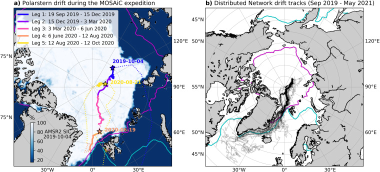
A network of autonomous, ice-tethered buoys was deployed around the Multidisciplinary drifting Observatory for the Study of Arctic Climate (MOSAiC) experiment in late September 2019 for a year-long drift in the Arctic Transpolar Drift Stream. The buoys were deployed as part of the MOSAiC distributed network (DN) which included 12 multi-instrumented ice stations and an additional 116 GPS buoys distributed primarily within a 40 km radius of the MOSAiC Central Observatory. Buoy coverage within the DN was maintained with additional deployments throughout the year-long drift allowing for collection of data over a full sea ice growth and melt cycle. All GPS position data from buoys deployed within the DN have been assembled and processed into the collection of 216 quality-controlled buoy drift tracks presented in this dataset covering the period 26 September 2019 - 23 May 2021. The drift tracks in this collection are ideal for studies of dynamic sea ice motion around the MOSAiC experiment at cascading spatial scales ranging from 100s of meters to 100s of km.
一个由自主、冰系泊浮标组成的网络于 2019 年 9 月下旬在北极多学科漂移观测站 MOSAiC 实验周围部署,以进行为期一年的北极跨极漂流的漂流。这些浮标是 MOSAiC 分布式网络(DN)的一部分,该网络包括 12 个多仪器冰站和另外 116 个 GPS 浮标,主要分布在 MOSAiC 中央观测站半径 40 公里范围内。通过全年的漂流进行额外的部署来维持 DN 内的浮标覆盖范围,从而在整个海冰生长和融化周期内收集数据。从 DN 内部署的浮标收集的所有 GPS 位置数据都已组装并处理到本数据集包含的 216 条经过质量控制的浮标漂流轨迹中,涵盖时间为 2019 年 9 月 26 日至 2021 年 5 月 23 日。本集合中的漂流轨迹非常适合研究 MOSAiC 实验周围动态海冰运动,空间尺度从数百米到数百公里不等。