Tóth Anikó B, Terauds Aleks, Chown Steven L, Hughes Kevin A, Convey Peter, Hodgson Dominic A, Cowan Don A, Gibson John, Leihy Rachel I, Murray Nicholas J, Robinson Sharon A, Shaw Justine D, Stark Jonathan S, Stevens Mark I, van den Hoff John, Wasley Jane, Keith David A
Centre for Ecosystem Science, School of Biological, Earth, and Environmental Sciences, University of New South Wales, Sydney, NSW 2052, Australia.
UNSW Data Science Hub, University of New South Wales, Sydney, NSW 2052, Australia.
Sci Data. 2025 Jan 22;12(1):133. doi: 10.1038/s41597-025-04424-y.
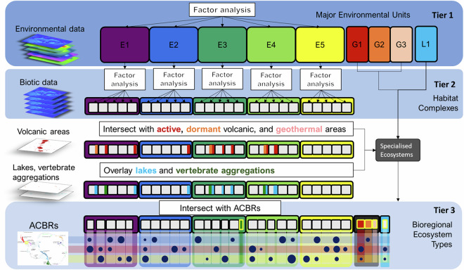
Antarctica, Earth's least understood and most remote continent, is threatened by human disturbances and climate-related changes, underscoring the imperative for biodiversity inventories to inform conservation. Antarctic ecosystems support unique species and genetic diversity, deliver essential ecosystem services and contribute to planetary stability. We present Antarctica's first comprehensive ecosystem classification and map of ice-free lands, which host most of the continent's biodiversity. We used latent variables in factor analyses to partition continental-scale abiotic variation, then biotic variation represented in spatial models, and finally recognised regional-scale variation among biogeographic units. This produced a spatially explicit hierarchical classification with nine Major Environment Units (Tier 1), 33 Habitat Complexes (Tier 2) and 269 Bioregional Ecosystem Types (Tier 3) mapped at 100 m resolution and aligned with 'level 4' of the IUCN Global Ecosystem Typology. This comprehensive ecosystem inventory provides foundational data to inform protected area designation under the Antarctic Treaty's Environmental Protocol and track risks to Antarctic ecosystems. Its tiered structure and workflow accommodate data scarcity and facilitate updates, promoting robustness as knowledge builds.
南极洲是地球上最不为人所知且最偏远的大陆,正受到人类干扰和气候相关变化的威胁,这凸显了开展生物多样性清查以指导保护工作的紧迫性。南极生态系统拥有独特的物种和遗传多样性,提供重要的生态系统服务,并有助于地球的稳定。我们展示了南极洲首个全面的生态系统分类以及无冰陆地地图,南极洲的大部分生物多样性都存在于这些无冰陆地上。我们在因子分析中使用潜在变量来划分大陆尺度的非生物变异,然后是空间模型中表示的生物变异,最后识别生物地理单元之间的区域尺度变异。这产生了一个空间明确的层次分类,包括九个主要环境单元(第1层)、33个栖息地复合体(第2层)和269个生物区域生态系统类型(第3层),以100米分辨率绘制,并与世界自然保护联盟全球生态系统类型学的“第4级”对齐。这个全面的生态系统清查提供了基础数据,以指导《南极条约环境议定书》下的保护区指定,并跟踪南极生态系统面临的风险。其分层结构和工作流程适应了数据稀缺的情况,并便于更新,随着知识的积累提高了稳健性。