Department of Geography, University of Montreal, 520 Chemin Cote Ste Catherine Outremont, Montreal H2V 2B8, Quebec, Canada.
Environ Manage. 2012 Jan;49(1):163-73. doi: 10.1007/s00267-011-9785-2. Epub 2011 Nov 23.
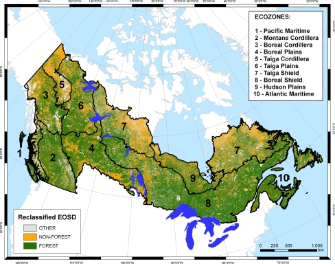
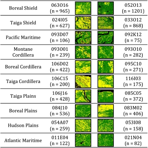
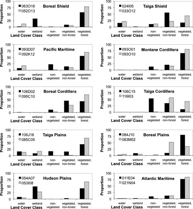
Canada is a large nation with forested ecosystems that occupy over 60% of the national land base, and knowledge of the patterns of Canada's land cover is important to proper environmental management of this vast resource. To this end, a circa 2000 Landsat-derived land cover map of the forested ecosystems of Canada has created a new window into understanding the composition and configuration of land cover patterns in forested Canada. Strategies for summarizing such large expanses of land cover are increasingly important, as land managers work to study and preserve distinctive areas, as well as to identify representative examples of current land-cover and land-use assemblages. Meanwhile, the development of extremely efficient clustering algorithms has become increasingly important in the world of computer science, in which billions of pieces of information on the internet are continually sifted for meaning for a vast variety of applications. One recently developed clustering algorithm quickly groups large numbers of items of any type in a given data set while simultaneously selecting a representative-or "exemplar"-from each cluster. In this context, the availability of both advanced data processing methods and a nationally available set of landscape metrics presents an opportunity to identify sets of representative landscapes to better understand landscape pattern, variation, and distribution across the forested area of Canada. In this research, we first identify and provide context for a small, interpretable set of exemplar landscapes that objectively represent land cover in each of Canada's ten forested ecozones. Then, we demonstrate how this approach can be used to identify flagship and satellite long-term study areas inside and outside protected areas in the province of Ontario. These applications aid our understanding of Canada's forest while augmenting its management toolbox, and may signal a broad range of applications for this versatile approach.
加拿大是一个拥有森林生态系统的大国,其面积占全国土地面积的 60%以上。了解加拿大土地覆盖的模式对于对这一巨大资源进行适当的环境管理至关重要。为此,大约在 2000 年,根据陆地卫星数据制作了一幅加拿大森林生态系统土地覆盖图,为了解加拿大森林的土地覆盖模式的组成和结构提供了一个新的视角。随着土地管理者努力研究和保护特色区域,并确定当前土地覆盖和土地利用组合的代表性示例,对这种大面积土地覆盖进行总结的策略变得越来越重要。与此同时,在计算机科学领域,开发极其高效的聚类算法变得越来越重要,因为互联网上不断有数十亿条关于信息被筛选以用于各种应用。最近开发的一种聚类算法可以快速对给定数据集中的大量任意类型的项目进行分组,同时从每个群集中选择一个代表项或“示例”。在这种情况下,先进的数据处理方法和全国范围内的景观指标集的可用性为确定一组具有代表性的景观提供了机会,以更好地了解加拿大森林地区的景观模式、变化和分布。在这项研究中,我们首先确定并为一组可解释的小示例景观提供背景信息,这些景观客观地代表了加拿大十个森林生态区中的每一个的土地覆盖。然后,我们展示了如何使用这种方法来确定安大略省保护区内外的旗舰和卫星长期研究区域。这些应用有助于我们了解加拿大的森林,同时丰富了其管理工具箱,并可能为这种多功能方法的广泛应用发出信号。