Institute of Marine Sciences, University of North Carolina at Chapel Hill, Morehead City, NC, USA.
PLoS One. 2012;7(12):e52694. doi: 10.1371/journal.pone.0052694. Epub 2012 Dec 20.
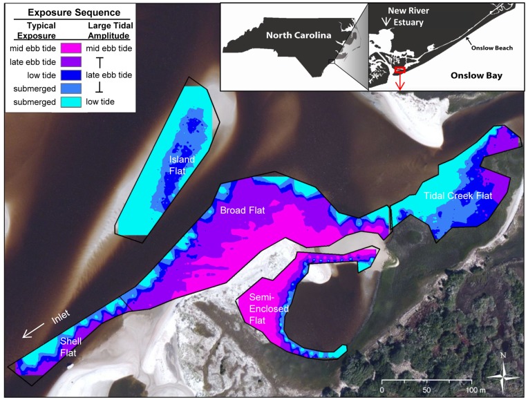
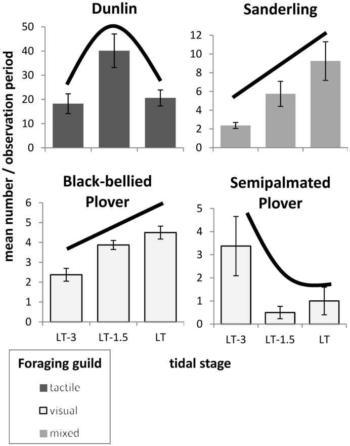
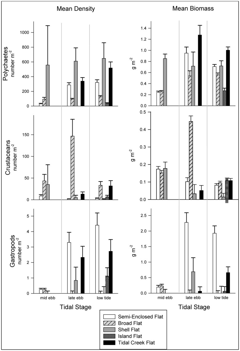
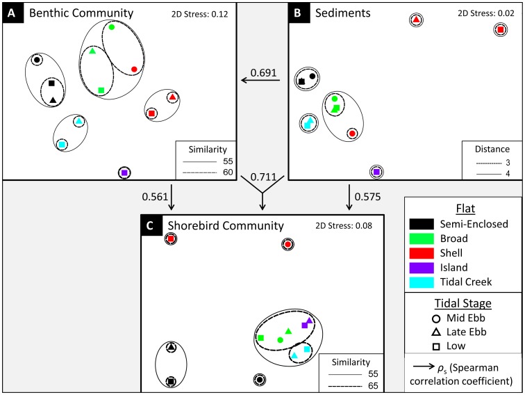
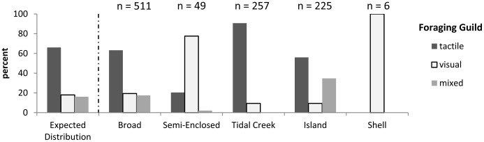
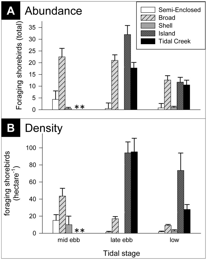
Worldwide declines in shorebird populations, driven largely by habitat loss and degradation, motivate environmental managers to preserve and restore the critical coastal habitats on which these birds depend. Effective habitat management requires an understanding of the factors that determine habitat use and value to shorebirds, extending from individuals to the entire community. While investigating the factors that influenced shorebird foraging distributions among neighboring intertidal sand flats, we built upon species-level understandings of individual-based, small-scale foraging decisions to develop more comprehensive guild- and community-level insights. We found that densities and community composition of foraging shorebirds varied substantially among elevations within some tidal flats and among five flats despite their proximity (all located within a 400-m stretch of natural, unmodified inlet shoreline). Non-dimensional multivariate analyses revealed that the changing composition of the shorebird community among flats and tidal elevations correlated significantly (ρ(s) = 0.56) with the spatial structure of the benthic invertebrate prey community. Sediment grain-sizes affected shorebird community spatial patterns indirectly by influencing benthic macroinvertebrate community compositions. Furthermore, combining sediment and macroinvertebrate information produced a 27% increase in correlation (ρ(s) = 0.71) with shorebird assemblage patterns over the correlation of the bird community with the macroinvertebrate community alone. Beyond its indirect effects acting through prey distributions, granulometry of the flats influenced shorebird foraging directly by modifying prey availability. Our study highlights the importance of habitat heterogeneity, showing that no single patch type was ideal for the entire shorebird community. Generally, shorebird density and diversity were greatest at lower elevations on flats when they became exposed; these areas are at risk from human intervention by inlet sand mining, construction of groins and jetties that divert sediments from flats, and installation of seawalls on inlet shorelines that induce erosion of flats.
全球范围内滨鸟数量下降,主要原因是生境丧失和退化,这促使环境管理者保护和恢复这些鸟类赖以生存的关键沿海生境。有效的生境管理需要了解决定滨鸟栖息地利用和价值的因素,这些因素从个体延伸到整个群落。在调查影响相邻潮间带沙滩上滨鸟觅食分布的因素时,我们在基于物种的个体尺度觅食决策的理解基础上,进一步发展了更全面的类群和群落尺度的见解。我们发现,尽管相邻(都位于自然未受干扰的入海口岸线 400 米范围内),但在一些潮滩内的不同海拔高度和五个潮滩之间,觅食滨鸟的密度和群落组成存在很大差异。非维多元分析表明,尽管群落之间的距离很近,但各潮滩和潮位之间滨鸟群落组成的变化与底栖无脊椎动物猎物群落的空间结构显著相关(ρ(s)=0.56)。沉积物粒径通过影响底栖大型无脊椎动物群落的组成,间接地影响滨鸟群落的空间格局。此外,将沉积物和大型底栖无脊椎动物信息结合起来,与仅将鸟类群落与大型底栖无脊椎动物群落相关联相比,相关系数(ρ(s)=0.71)增加了 27%,与滨鸟组合模式的相关性更高。除了通过猎物分布产生间接影响外,沙滩的粒度特征还直接通过改变猎物的可利用性来影响滨鸟的觅食行为。本研究强调了生境异质性的重要性,表明没有单一的斑块类型对整个滨鸟群落都是理想的。一般来说,当潮滩在较低海拔处暴露出来时,滨鸟的密度和多样性最大;这些区域容易受到人类干预的影响,如入海口的沙滩开采、防波堤和突堤的建设,这些设施会使沉积物从沙滩上转移,以及在入海口岸线上安装防波堤,这会导致沙滩的侵蚀。