• 文献检索
  • 文档翻译
  • 深度研究
  • 学术资讯
  • Suppr Zotero 插件Zotero 插件
  • 邀请有礼
  • 套餐&价格
  • 历史记录
应用&插件
Suppr Zotero 插件Zotero 插件浏览器插件Mac 客户端Windows 客户端微信小程序
定价
高级版会员购买积分包购买API积分包
服务
文献检索文档翻译深度研究API 文档MCP 服务
关于我们
关于 Suppr公司介绍联系我们用户协议隐私条款
关注我们

Suppr 超能文献

核心技术专利:CN118964589B侵权必究
粤ICP备2023148730 号-1Suppr @ 2026

文献检索

告别复杂PubMed语法,用中文像聊天一样搜索,搜遍4000万医学文献。AI智能推荐,让科研检索更轻松。

立即免费搜索

文件翻译

保留排版,准确专业,支持PDF/Word/PPT等文件格式,支持 12+语言互译。

免费翻译文档

深度研究

AI帮你快速写综述,25分钟生成高质量综述,智能提取关键信息,辅助科研写作。

立即免费体验

一种用于大型户外区域导航和障碍物测绘的空-地机器人系统。

An aerial–ground robotic system for navigation and obstacle mapping in large outdoor areas.

机构信息

Centro De Automética y Robótica, UPM-CSIC, Madrid, Spain.

出版信息

Sensors (Basel). 2013 Jan 21;13(1):1247-67. doi: 10.3390/s130101247.

DOI:10.3390/s130101247
PMID:23337332
原文链接:https://pmc.ncbi.nlm.nih.gov/articles/PMC3574734/
Abstract

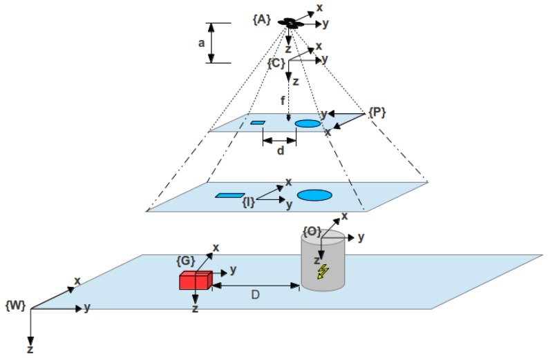
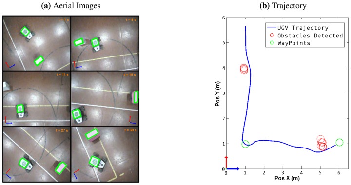
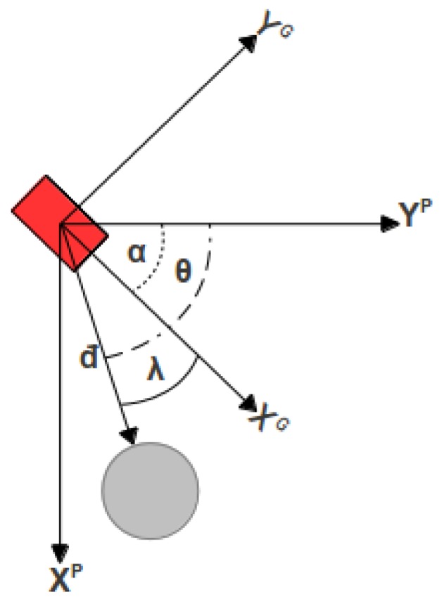
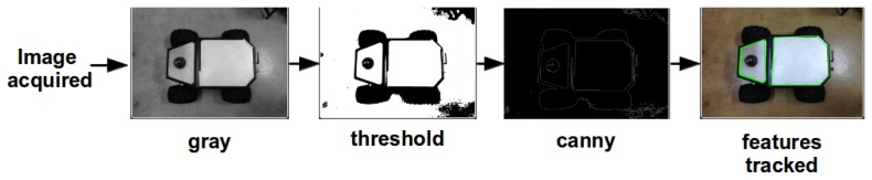
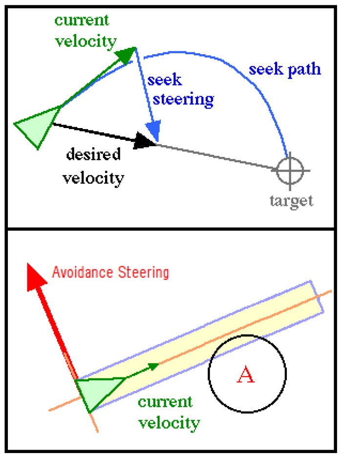
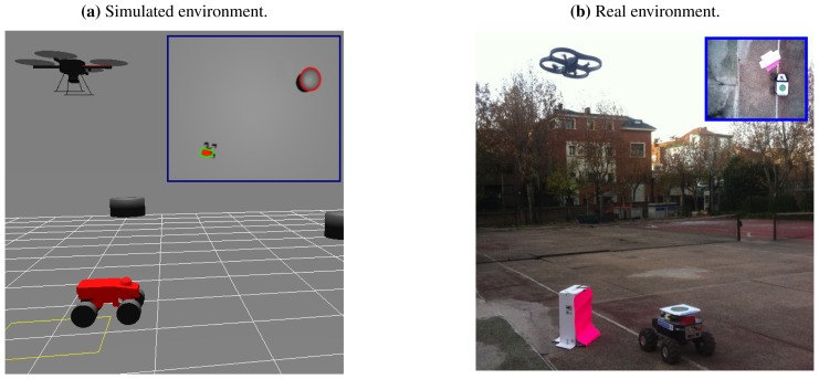
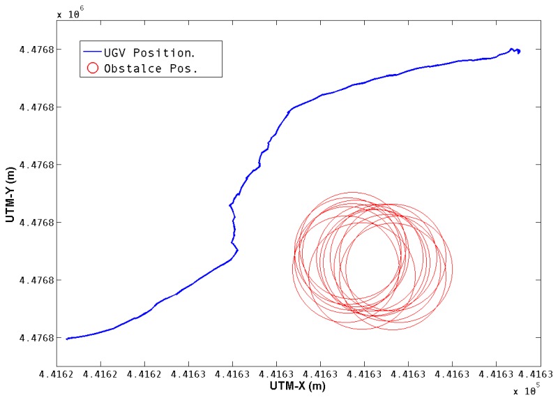
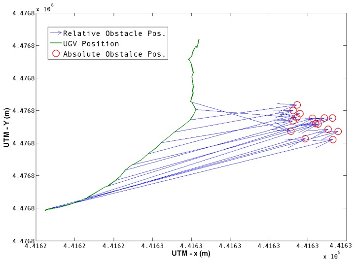
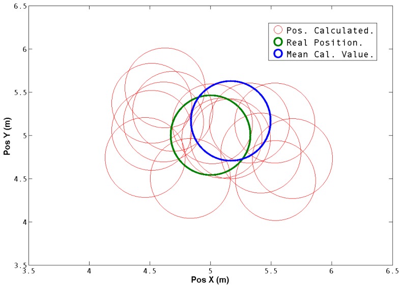
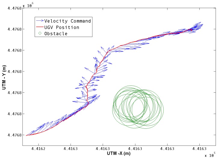
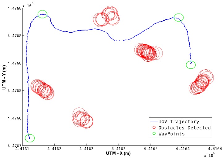
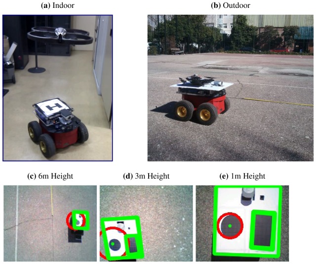
There are many outdoor robotic applications where a robot must reach a goal position or explore an area without previous knowledge of the environment around it. Additionally, other applications (like path planning) require the use of known maps or previous information of the environment. This work presents a system composed by a terrestrial and an aerial robot that cooperate and share sensor information in order to address those requirements. The ground robot is able to navigate in an unknown large environment aided by visual feedback from a camera on board the aerial robot. At the same time, the obstacles are mapped in real-time by putting together the information from the camera and the positioning system of the ground robot. A set of experiments were carried out with the purpose of verifying the system applicability. The experiments were performed in a simulation environment and outdoor with a medium-sized ground robot and a mini quad-rotor. The proposed robotic system shows outstanding results in simultaneous navigation and mapping applications in large outdoor environments.

摘要

有许多户外机器人应用场景,机器人必须到达目标位置或在不了解周围环境的情况下探索某个区域。此外,其他应用(如路径规划)需要使用已知地图或环境的先前信息。这项工作提出了一个由陆地机器人和空中机器人组成的系统,它们通过共享传感器信息来协作,以满足这些需求。地面机器人可以在未知的大环境中导航,其方法是借助搭载在空机器人上的摄像头提供的视觉反馈。同时,障碍物通过将摄像头和地面机器人定位系统的信息组合起来进行实时映射。进行了一组实验,目的是验证系统的适用性。实验是在模拟环境中和户外进行的,使用的是中型地面机器人和小型四旋翼飞行器。所提出的机器人系统在大型户外环境中的同时导航和映射应用中表现出色。

https://cdn.ncbi.nlm.nih.gov/pmc/blobs/850e/3574734/eea4bfc4e15c/sensors-13-01247f13.jpg
https://cdn.ncbi.nlm.nih.gov/pmc/blobs/850e/3574734/632403260fbd/sensors-13-01247f1.jpg
https://cdn.ncbi.nlm.nih.gov/pmc/blobs/850e/3574734/623a77465515/sensors-13-01247f2.jpg
https://cdn.ncbi.nlm.nih.gov/pmc/blobs/850e/3574734/82ef5f651022/sensors-13-01247f3.jpg
https://cdn.ncbi.nlm.nih.gov/pmc/blobs/850e/3574734/6c4dba2cce17/sensors-13-01247f4.jpg
https://cdn.ncbi.nlm.nih.gov/pmc/blobs/850e/3574734/3dd5d09c06b3/sensors-13-01247f5.jpg
https://cdn.ncbi.nlm.nih.gov/pmc/blobs/850e/3574734/81cb023250dd/sensors-13-01247f6.jpg
https://cdn.ncbi.nlm.nih.gov/pmc/blobs/850e/3574734/19e1994283b0/sensors-13-01247f7.jpg
https://cdn.ncbi.nlm.nih.gov/pmc/blobs/850e/3574734/656dd36ed5cb/sensors-13-01247f8.jpg
https://cdn.ncbi.nlm.nih.gov/pmc/blobs/850e/3574734/6b6fb9e25154/sensors-13-01247f9.jpg
https://cdn.ncbi.nlm.nih.gov/pmc/blobs/850e/3574734/6c6ecb91f79f/sensors-13-01247f10.jpg
https://cdn.ncbi.nlm.nih.gov/pmc/blobs/850e/3574734/5d65d5a55520/sensors-13-01247f11.jpg
https://cdn.ncbi.nlm.nih.gov/pmc/blobs/850e/3574734/50f2ae2ef334/sensors-13-01247f12.jpg
https://cdn.ncbi.nlm.nih.gov/pmc/blobs/850e/3574734/eea4bfc4e15c/sensors-13-01247f13.jpg

相似文献

1
An aerial–ground robotic system for navigation and obstacle mapping in large outdoor areas.一种用于大型户外区域导航和障碍物测绘的空-地机器人系统。
Sensors (Basel). 2013 Jan 21;13(1):1247-67. doi: 10.3390/s130101247.
2
Magnetic-Field-Inspired Navigation for Robots in Complex and Unknown Environments.复杂未知环境中受磁场启发的机器人导航
Front Robot AI. 2022 Feb 18;9:834177. doi: 10.3389/frobt.2022.834177. eCollection 2022.
3
A 2.5D Map-Based Mobile Robot Localization via Cooperation of Aerial and Ground Robots.一种通过空中和地面机器人协作实现的基于2.5D地图的移动机器人定位
Sensors (Basel). 2017 Nov 25;17(12):2730. doi: 10.3390/s17122730.
4
Symbiotic Navigation in Multi-Robot Systems with Remote Obstacle Knowledge Sharing.具有远程障碍物知识共享的多机器人系统中的共生导航
Sensors (Basel). 2017 Jul 5;17(7):1581. doi: 10.3390/s17071581.
5
Deep Reinforcement Learning for End-to-End Local Motion Planning of Autonomous Aerial Robots in Unknown Outdoor Environments: Real-Time Flight Experiments.未知户外环境中自主飞行机器人端到端局部运动规划的深度强化学习:实时飞行实验
Sensors (Basel). 2021 Apr 4;21(7):2534. doi: 10.3390/s21072534.
6
A hierarchical model of goal directed navigation selects trajectories in a visual environment.目标导向导航的层次模型在视觉环境中选择轨迹。
Neurobiol Learn Mem. 2015 Jan;117:109-21. doi: 10.1016/j.nlm.2014.07.003. Epub 2014 Jul 29.
7
Traversability analysis with vision and terrain probing for safe legged robot navigation.基于视觉和地形探测的可通行性分析用于安全的腿部机器人导航。
Front Robot AI. 2022 Aug 22;9:887910. doi: 10.3389/frobt.2022.887910. eCollection 2022.
8
Learning indoor robot navigation using visual and sensorimotor map information.利用视觉和运动感知地图信息学习室内机器人导航。
Front Neurorobot. 2013 Oct 7;7:15. doi: 10.3389/fnbot.2013.00015. eCollection 2013.
9
Online Aerial Terrain Mapping for Ground Robot Navigation.用于地面机器人导航的在线航空地形测绘
Sensors (Basel). 2018 Feb 20;18(2):630. doi: 10.3390/s18020630.
10
An Eight-Direction Scanning Detection Algorithm for the Mapping Robot Pathfinding in Unknown Indoor Environment.一种用于未知室内环境中测绘机器人路径规划的八向扫描检测算法。
Sensors (Basel). 2018 Dec 4;18(12):4254. doi: 10.3390/s18124254.

引用本文的文献

1
Robust Localization of Industrial Park UGV and Prior Map Maintenance.工业园区无人地面车辆的稳健定位及先验地图维护
Sensors (Basel). 2023 Aug 6;23(15):6987. doi: 10.3390/s23156987.
2
Design and Experimental Evaluation of an Odor Sensing Method for a Pocket-Sized Quadcopter.一种用于口袋型四旋翼飞行器的气味感知方法的设计与实验评估。
Sensors (Basel). 2018 Nov 1;18(11):3720. doi: 10.3390/s18113720.
3
A 2.5D Map-Based Mobile Robot Localization via Cooperation of Aerial and Ground Robots.一种通过空中和地面机器人协作实现的基于2.5D地图的移动机器人定位
Sensors (Basel). 2017 Nov 25;17(12):2730. doi: 10.3390/s17122730.
4
Heterogeneous Multi-Robot System for Mapping Environmental Variables of Greenhouses.用于绘制温室环境变量的异构多机器人系统。
Sensors (Basel). 2016 Jul 1;16(7):1018. doi: 10.3390/s16071018.
5
Enabling UAV Navigation with Sensor and Environmental Uncertainty in Cluttered and GPS-Denied Environments.在复杂且无GPS信号的环境中利用传感器和环境不确定性实现无人机导航
Sensors (Basel). 2016 May 10;16(5):666. doi: 10.3390/s16050666.
6
Motion planning for autonomous vehicle based on radial basis function neural network in unstructured environment.基于径向基函数神经网络的非结构化环境下自动驾驶车辆运动规划
Sensors (Basel). 2014 Sep 18;14(9):17548-66. doi: 10.3390/s140917548.
7
Multi-agent cooperative target search.多智能体协作目标搜索
Sensors (Basel). 2014 May 26;14(6):9408-28. doi: 10.3390/s140609408.
8
Introduction to the special issue on "New trends towards automatic vehicle control and perception systems".“自动车辆控制与感知系统的新趋势”特刊引言
Sensors (Basel). 2013 May 2;13(5):5712-9. doi: 10.3390/s130505712.