School of Applied Sciences, Bournemouth University, Talbot Campus, Fern Barrow, Poole, Dorset, United Kingdom.
PLoS One. 2013 Apr 17;8(4):e60755. doi: 10.1371/journal.pone.0060755. Print 2013.
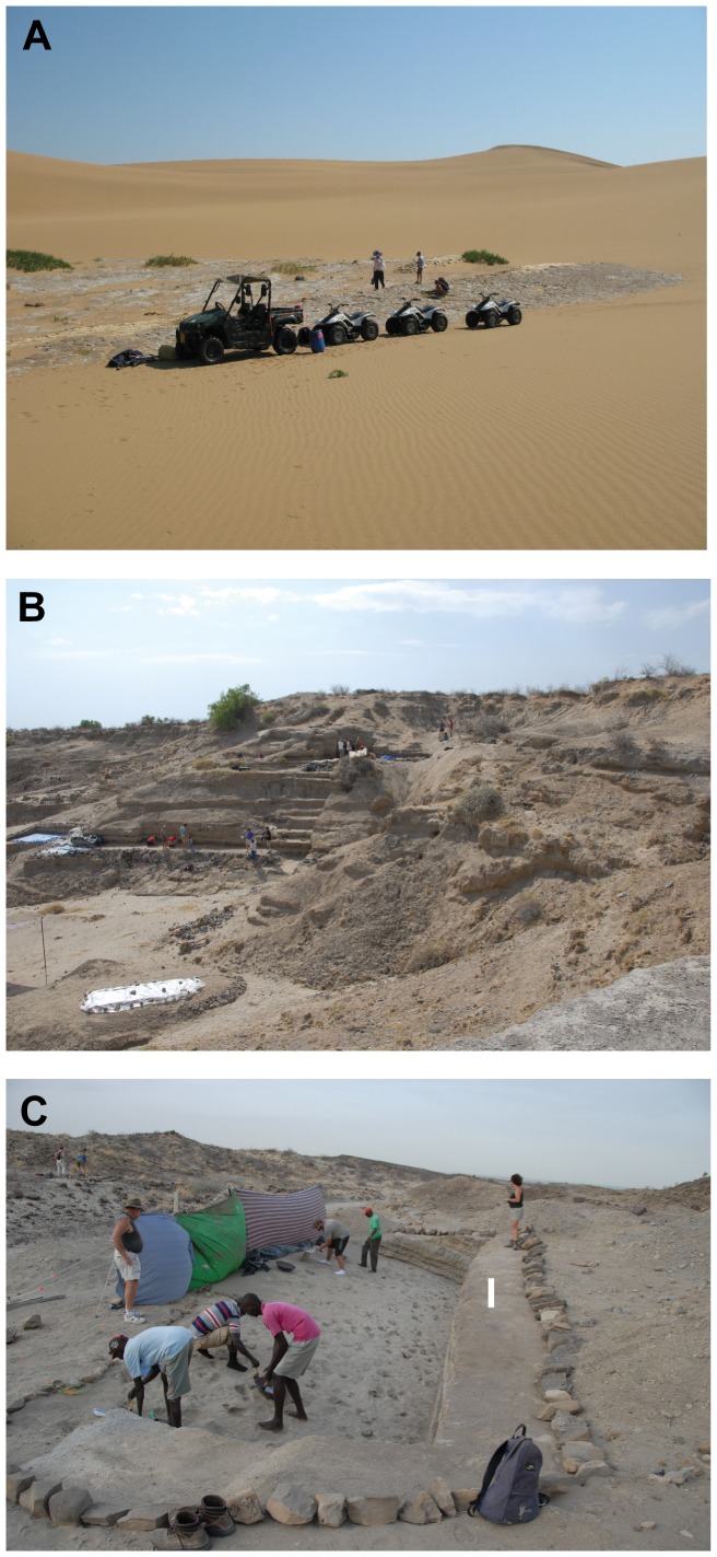
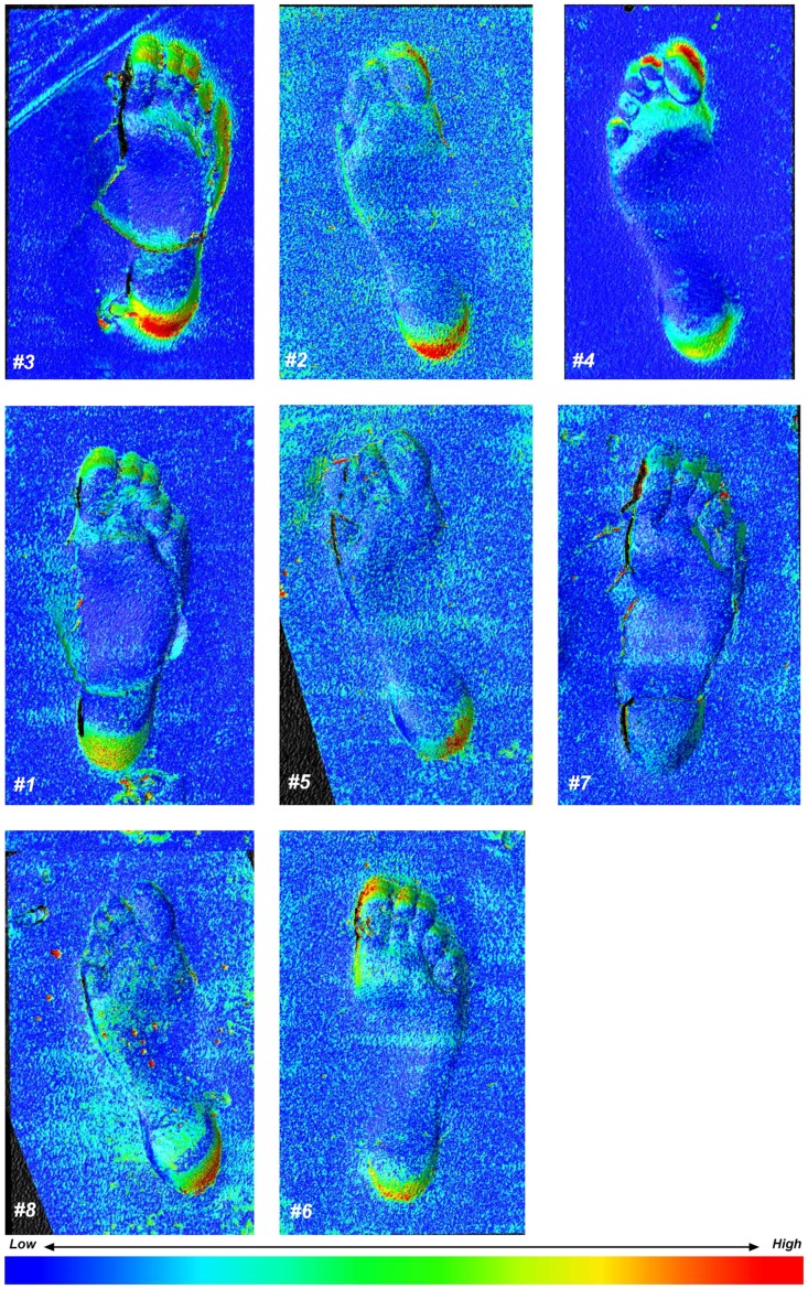
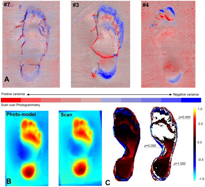
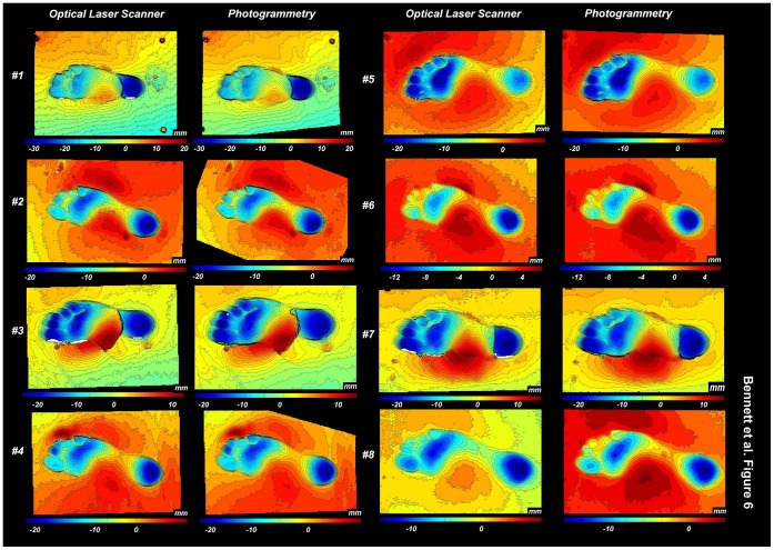
Human footprints provide some of the most publically emotive and tangible evidence of our ancestors. To the scientific community they provide evidence of stature, presence, behaviour and in the case of early hominins potential evidence with respect to the evolution of gait. While rare in the geological record the number of footprint sites has increased in recent years along with the analytical tools available for their study. Many of these sites are at risk from rapid erosion, including the Ileret footprints in northern Kenya which are second only in age to those at Laetoli (Tanzania). Unlithified, soft-sediment footprint sites such these pose a significant geoconservation challenge. In the first part of this paper conservation and preservation options are explored leading to the conclusion that to 'record and digitally rescue' provides the only viable approach. Key to such strategies is the increasing availability of three-dimensional data capture either via optical laser scanning and/or digital photogrammetry. Within the discipline there is a developing schism between those that favour one approach over the other and a requirement from geoconservationists and the scientific community for some form of objective appraisal of these alternatives is necessary. Consequently in the second part of this paper we evaluate these alternative approaches and the role they can play in a 'record and digitally rescue' conservation strategy. Using modern footprint data, digital models created via optical laser scanning are compared to those generated by state-of-the-art photogrammetry. Both methods give comparable although subtly different results. This data is evaluated alongside a review of field deployment issues to provide guidance to the community with respect to the factors which need to be considered in digital conservation of human/hominin footprints.
人类足迹为我们的祖先提供了一些最公开、最具情感和最有形的证据。对于科学界来说,它们提供了身高、存在、行为的证据,而就早期人类而言,它们提供了关于步态进化的潜在证据。虽然在地质记录中很少见,但近年来,足迹遗址的数量随着研究这些遗址的分析工具的增加而增加。这些遗址中的许多都面临着快速侵蚀的风险,包括肯尼亚北部的 Ileret 足迹,其年代仅次于坦桑尼亚的 Laetoli。未风化的软沉积足迹遗址,如这些,构成了重大的地质保护挑战。本文的第一部分探讨了保护和保存的选择方案,结论是“记录和数字抢救”提供了唯一可行的方法。这些策略的关键是越来越多地通过光学激光扫描和/或数字摄影测量获得三维数据捕获。在该学科内部,对于偏好一种方法而不是另一种方法的人之间存在分歧,地质保护主义者和科学界都需要对这些替代方案进行某种形式的客观评估。因此,本文的第二部分评估了这些替代方法,以及它们在“记录和数字抢救”保护策略中可以发挥的作用。使用现代足迹数据,通过光学激光扫描创建的数字模型与通过最先进的摄影测量生成的模型进行了比较。这两种方法都给出了类似的但略有不同的结果。该数据与对现场部署问题的审查一起进行评估,为社区提供了有关在数字保护人类/人类足迹时需要考虑的因素的指导。