• 文献检索
  • 文档翻译
  • 深度研究
  • 学术资讯
  • Suppr Zotero 插件Zotero 插件
  • 邀请有礼
  • 套餐&价格
  • 历史记录
应用&插件
Suppr Zotero 插件Zotero 插件浏览器插件Mac 客户端Windows 客户端微信小程序
定价
高级版会员购买积分包购买API积分包
服务
文献检索文档翻译深度研究API 文档MCP 服务
关于我们
关于 Suppr公司介绍联系我们用户协议隐私条款
关注我们

Suppr 超能文献

核心技术专利:CN118964589B侵权必究
粤ICP备2023148730 号-1Suppr @ 2026

文献检索

告别复杂PubMed语法,用中文像聊天一样搜索,搜遍4000万医学文献。AI智能推荐,让科研检索更轻松。

立即免费搜索

文件翻译

保留排版,准确专业,支持PDF/Word/PPT等文件格式,支持 12+语言互译。

免费翻译文档

深度研究

AI帮你快速写综述,25分钟生成高质量综述,智能提取关键信息,辅助科研写作。

立即免费体验

通过GPS与GRACE联合分析探测到的西藏南部季节性水文负荷

Seasonal Hydrological Loading in Southern Tibet Detected by Joint Analysis of GPS and GRACE.

作者信息

Zou Rong, Wang Qi, Freymueller Jeffrey T, Poutanen Markku, Cao Xuelian, Zhang Caihong, Yang Shaomin, He Ping

机构信息

Hubei Subsurface Multi-Scale Imaging Key Laboratory, Institute of Geophysics & Geomatics, China University of Geosciences (Wuhan), Wuhan 430074, China.

Finnish Geospatial Research Institute FGI, Geodeetinrinne 2, Masala 02430, Finland.

出版信息

Sensors (Basel). 2015 Dec 4;15(12):30525-38. doi: 10.3390/s151229815.

DOI:10.3390/s151229815
PMID:26690157
原文链接:https://pmc.ncbi.nlm.nih.gov/articles/PMC4721735/
Abstract

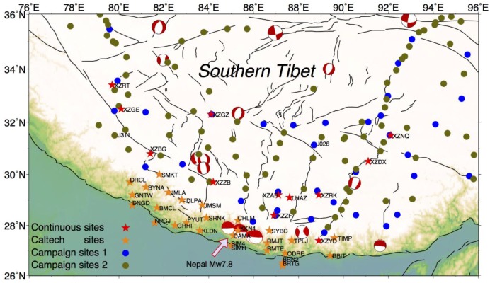
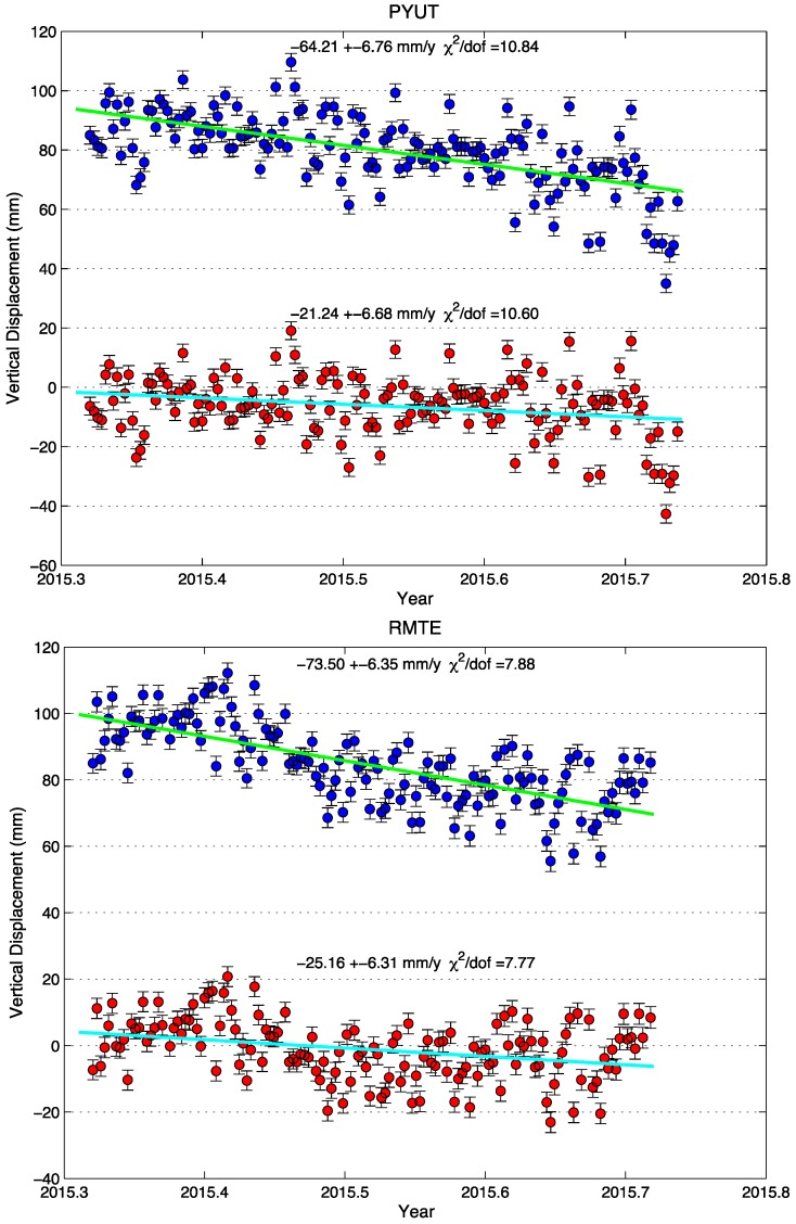
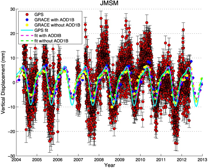
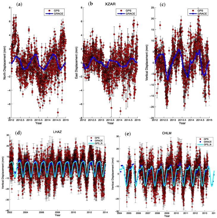
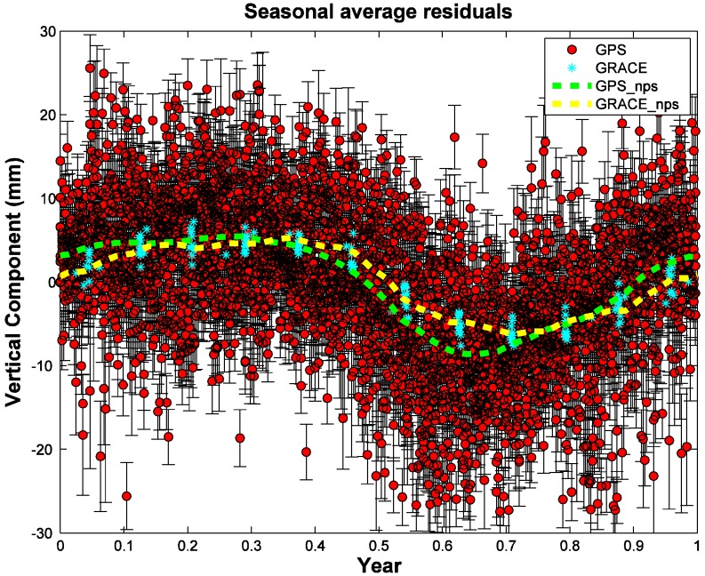
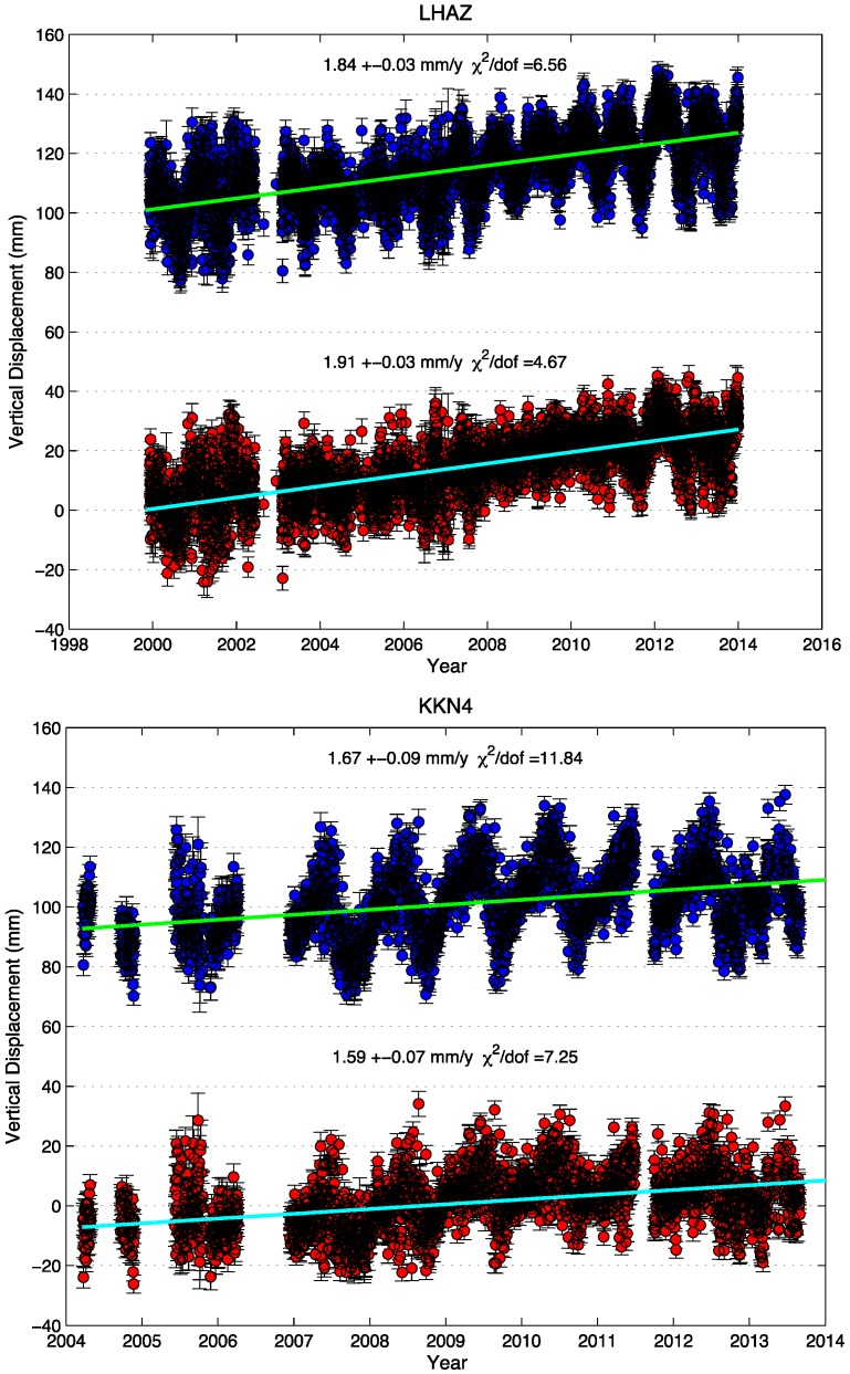
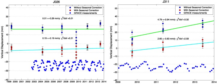
In southern Tibet, ongoing vertical and horizontal motions due to the collision between India and Eurasia are monitored by large numbers of global positioning system (GPS) continuous and campaign sites installed in the past decade. Displacements measured by GPS usually include tectonic deformation as well as non-tectonic, time-dependent signals. To estimate the regional long-term tectonic deformation using GPS more precisely, seasonal elastic deformation signals associated with surface loading must be removed from the observations. In this study, we focus on seasonal variation in vertical and horizontal motions of southern Tibet by performing a joint analysis of GRACE (Gravity Recovery and Climate Experiment) and GPS data, not only using continuous sites but also GPS campaign-mode sites. We found that the GPS-observed and GRACE-modeled seasonal oscillations are in good agreements, and a seasonal displacement model demonstrates that the main reason for seasonal variations in southern Tibet is from the summer monsoon and its precipitation. The biggest loading appears from July to August in the summer season. Vertical deformations observed by GPS and modeled by GRACE are two to three times larger than horizontal oscillations, and the north components demonstrate larger amplitudes than the east components. We corrected the GPS position time series using the GRACE-modeled seasonal variations, which gives significant reductions in the misfit and weighted root-mean-squares (WRMS). Misfit (χ2 divided by degree of freedom) reductions for campaign sites range between 20% and 56% for the vertical component, and are much smaller for the horizontal components. Moreover, time series of continuous GPS (cGPS) sites near the 2015 Nepal earthquakes must be corrected using appropriate models of seasonal loading for analyzing postseismic deformation to avoid biasing estimates of the postseismic relaxation.

摘要

在西藏南部,过去十年间安装的大量全球定位系统(GPS)连续监测站点和流动站点对印度与欧亚大陆碰撞导致的持续垂直和水平运动进行着监测。GPS测量的位移通常包括构造变形以及非构造的、随时间变化的信号。为了更精确地利用GPS估算区域长期构造变形,必须从观测数据中去除与地表负荷相关的季节性弹性变形信号。在本研究中,我们通过对GRACE(重力恢复与气候实验)和GPS数据进行联合分析,不仅使用连续站点,还使用GPS流动模式站点,来关注西藏南部垂直和水平运动的季节性变化。我们发现GPS观测到的和GRACE模拟的季节性振荡吻合良好,并且一个季节性位移模型表明,西藏南部季节性变化的主要原因来自夏季风及其降水。最大的负荷出现在夏季的7月至8月。GPS观测到的垂直变形和GRACE模拟的垂直变形比水平振荡大两到三倍,北向分量的振幅比东向分量大。我们使用GRACE模拟的季节性变化对GPS位置时间序列进行了校正,这显著降低了失配和加权均方根(WRMS)。流动站点垂直分量的失配(χ²除以自由度)降低幅度在20%至56%之间,水平分量的降低幅度要小得多。此外,对于2015年尼泊尔地震附近的连续GPS(cGPS)站点的时间序列,必须使用适当的季节性负荷模型进行校正,以便分析震后变形,避免对震后松弛的估计产生偏差。

https://cdn.ncbi.nlm.nih.gov/pmc/blobs/28e7/4721735/9a2302571f37/sensors-15-29815-g007.jpg
https://cdn.ncbi.nlm.nih.gov/pmc/blobs/28e7/4721735/08c24ac9cd46/sensors-15-29815-g001.jpg
https://cdn.ncbi.nlm.nih.gov/pmc/blobs/28e7/4721735/1096e1767a80/sensors-15-29815-g002.jpg
https://cdn.ncbi.nlm.nih.gov/pmc/blobs/28e7/4721735/e6ebb309900e/sensors-15-29815-g003.jpg
https://cdn.ncbi.nlm.nih.gov/pmc/blobs/28e7/4721735/bae4e5c574e3/sensors-15-29815-g004.jpg
https://cdn.ncbi.nlm.nih.gov/pmc/blobs/28e7/4721735/7adfc9ec9990/sensors-15-29815-g005.jpg
https://cdn.ncbi.nlm.nih.gov/pmc/blobs/28e7/4721735/92955cfde726/sensors-15-29815-g006.jpg
https://cdn.ncbi.nlm.nih.gov/pmc/blobs/28e7/4721735/9a2302571f37/sensors-15-29815-g007.jpg

相似文献

1
Seasonal Hydrological Loading in Southern Tibet Detected by Joint Analysis of GPS and GRACE.通过GPS与GRACE联合分析探测到的西藏南部季节性水文负荷
Sensors (Basel). 2015 Dec 4;15(12):30525-38. doi: 10.3390/s151229815.
2
Seasonal Mass Changes and Crustal Vertical Deformations Constrained by GPS and GRACE in Northeastern Tibet.利用GPS和GRACE对藏东北季节性质量变化与地壳垂直形变的约束
Sensors (Basel). 2016 Aug 2;16(8):1211. doi: 10.3390/s16081211.
3
Temporal-Spatial Surface Seasonal Mass Changes and Vertical Crustal Deformation in South China Block from GPS and GRACE Measurements.基于GPS和GRACE测量的华南地块时空地表季节性质量变化与地壳垂直形变
Sensors (Basel). 2017 Dec 31;18(1):99. doi: 10.3390/s18010099.
4
Earth surface deformation in the North China Plain detected by joint analysis of GRACE and GPS data.通过GRACE和GPS数据联合分析检测华北平原的地表形变
Sensors (Basel). 2014 Oct 22;14(10):19861-76. doi: 10.3390/s141019861.
5
The quasi-biennial vertical oscillations at global GPS stations: identification by ensemble empirical mode decomposition.全球GPS台站的准两年垂直振荡:通过总体经验模态分解进行识别
Sensors (Basel). 2015 Oct 14;15(10):26096-114. doi: 10.3390/s151026096.
6
Impacts of Local Effects and Surface Loads on the Common Mode Error Filtering in Continuous GPS Measurements in the Northwest of Yunnan Province, China.中国云南省西北部连续GPS测量中局部效应和表面负荷对共模误差滤波的影响
Sensors (Basel). 2020 Sep 21;20(18):5408. doi: 10.3390/s20185408.
7
Potential Seasonal Terrestrial Water Storage Monitoring from GPS Vertical Displacements: A Case Study in the Lower Three-Rivers Headwater Region, China.基于GPS垂直位移的潜在季节性陆地水储量监测:以中国三江源地区下游为例
Sensors (Basel). 2016 Sep 19;16(9):1526. doi: 10.3390/s16091526.
8
Annual variations of monsoon and drought detected by GPS: A case study in Yunnan, China.利用 GPS 探测季风和干旱的年际变化:以中国云南为例。
Sci Rep. 2017 Jul 19;7(1):5874. doi: 10.1038/s41598-017-06095-1.
9
Akaike's Bayesian Information Criterion for the Joint Inversion of Terrestrial Water Storage Using GPS Vertical Displacements, GRACE and GLDAS in Southwest China.利用GPS垂直位移、GRACE和GLDAS联合反演中国西南地区陆地水储量的赤池贝叶斯信息准则
Entropy (Basel). 2019 Jul 7;21(7):664. doi: 10.3390/e21070664.
10
Space-based observations of crustal deflections for drought characterization in Brazil.基于天基观测的巴西干旱特征描述的地壳挠度研究。
Sci Total Environ. 2018 Dec 10;644:256-273. doi: 10.1016/j.scitotenv.2018.06.277. Epub 2018 Jul 5.

引用本文的文献

1
Spatial-Temporal Dynamic Evolution of Land Deformation Driven by Hydrological Signals around Chaohu Lake.巢湖周边水文信号驱动下土地变形的时空动态演变
Sensors (Basel). 2024 Feb 12;24(4):1198. doi: 10.3390/s24041198.
2
Regional Crustal Vertical Deformation Driven by Terrestrial Water Load Depending on CORS Network and Environmental Loading Data: A Case Study of Southeast Zhejiang.基于CORS网络和环境荷载数据的陆地水荷载驱动的区域地壳垂直形变——以浙东南地区为例
Sensors (Basel). 2021 Nov 19;21(22):7699. doi: 10.3390/s21227699.
3
Terrestrial Water Storage in African Hydrological Regimes Derived from GRACE Mission Data: Intercomparison of Spherical Harmonics, Mass Concentration, and Scalar Slepian Methods.

本文引用的文献

1
Earth surface deformation in the North China Plain detected by joint analysis of GRACE and GPS data.通过GRACE和GPS数据联合分析检测华北平原的地表形变
Sensors (Basel). 2014 Oct 22;14(10):19861-76. doi: 10.3390/s141019861.
2
Bedrock displacements in Greenland manifest ice mass variations, climate cycles and climate change.格陵兰岛基岩位移表现出冰量变化、气候周期和气候变化。
Proc Natl Acad Sci U S A. 2012 Jul 24;109(30):11944-8. doi: 10.1073/pnas.1204664109. Epub 2012 Jul 11.
3
Cenozoic Tectonics of Asia: Effects of a Continental Collision: Features of recent continental tectonics in Asia can be interpreted as results of the India-Eurasia collision.
基于GRACE任务数据的非洲水文状况中的陆地水储量:球谐函数、质量浓度和标量斯莱皮恩方法的相互比较
Sensors (Basel). 2017 Mar 10;17(3):566. doi: 10.3390/s17030566.
4
Coseismic Gravity and Displacement Signatures Induced by the 2013 Okhotsk Mw8.3 Earthquake.2013年鄂霍次克海8.3级地震引发的同震重力和位移特征
Sensors (Basel). 2016 Sep 1;16(9):1410. doi: 10.3390/s16091410.
亚洲新生代构造:大陆碰撞的影响:亚洲近期大陆构造的特征可被解释为印度-欧亚大陆碰撞的结果。
Science. 1975 Aug 8;189(4201):419-26. doi: 10.1126/science.189.4201.419.
4
Satellite gravity measurements confirm accelerated melting of Greenland ice sheet.卫星重力测量证实格陵兰冰盖加速融化。
Science. 2006 Sep 29;313(5795):1958-60. doi: 10.1126/science.1129007. Epub 2006 Aug 10.
5
GRACE measurements of mass variability in the Earth system.全球陆面同化系统(GRACE)对地球系统质量变化的测量。
Science. 2004 Jul 23;305(5683):503-5. doi: 10.1126/science.1099192.
6
A new global mode of Earth deformation: seasonal cycle detected.地球变形的一种新的全球模式:检测到季节性周期。
Science. 2001 Dec 14;294(5550):2342-5. doi: 10.1126/science.1065328.
7
Present-day crustal deformation in China constrained by global positioning system measurements.全球定位系统测量对中国现今地壳形变的约束
Science. 2001 Oct 19;294(5542):574-7. doi: 10.1126/science.1063647.
8
Seasonal modulation of interseismic strain buildup in northeastern Japan driven by snow loads.雪荷载驱动下日本东北部地震间歇期应变积累的季节性调制。
Science. 2001 Jul 6;293(5527):89-92. doi: 10.1126/science.1061056.