• 文献检索
  • 文档翻译
  • 深度研究
  • 学术资讯
  • Suppr Zotero 插件Zotero 插件
  • 邀请有礼
  • 套餐&价格
  • 历史记录
应用&插件
Suppr Zotero 插件Zotero 插件浏览器插件Mac 客户端Windows 客户端微信小程序
定价
高级版会员购买积分包购买API积分包
服务
文献检索文档翻译深度研究API 文档MCP 服务
关于我们
关于 Suppr公司介绍联系我们用户协议隐私条款
关注我们

Suppr 超能文献

核心技术专利:CN118964589B侵权必究
粤ICP备2023148730 号-1Suppr @ 2026

文献检索

告别复杂PubMed语法,用中文像聊天一样搜索,搜遍4000万医学文献。AI智能推荐,让科研检索更轻松。

立即免费搜索

文件翻译

保留排版,准确专业,支持PDF/Word/PPT等文件格式,支持 12+语言互译。

免费翻译文档

深度研究

AI帮你快速写综述,25分钟生成高质量综述,智能提取关键信息,辅助科研写作。

立即免费体验

评估不同数字高程模型以分析山区地形的排水形态测量参数:以印度喜马拉雅山脉苏平-上通斯河流域为例

Evaluation of different digital elevation models for analyzing drainage morphometric parameters in a mountainous terrain: a case study of the Supin-Upper Tons Basin, Indian Himalayas.

作者信息

Das Sayantan, Patel Priyank Pravin, Sengupta Somasis

机构信息

Department of Geography, Bhairab Ganguly College, 2, Feeder Road, Belghoria, Kolkata, West Bengal 700056 India.

Department of Geography, Presidency University, 86/1, College Street, Kolkata, West Bengal 700073 India.

出版信息

Springerplus. 2016 Sep 13;5(1):1544. doi: 10.1186/s40064-016-3207-0. eCollection 2016.

DOI:10.1186/s40064-016-3207-0
PMID:27652117
原文链接:https://pmc.ncbi.nlm.nih.gov/articles/PMC5020020/
Abstract

BACKGROUND

With myriad geospatial datasets now available for terrain information extraction and particularly streamline demarcation, there arises questions regarding the scale, accuracy and sensitivity of the initial dataset from which these aspects are derived, as they influence all other parameters computed subsequently. In this study, digital elevation models (DEM) derived from Advanced Spaceborne Thermal Emission and Reflection Radiometer (ASTER V2), Shuttle Radar Topography Mission (SRTM V4, C-Band, 3 arc-second), Cartosat -1 (CartoDEM 1.0) and topographical maps (R.F. 1:250,000 and 1:50,000), have been used to individually extract and analyze the relief, surface, size, shape and texture properties of a mountainous drainage basin.

RESULTS

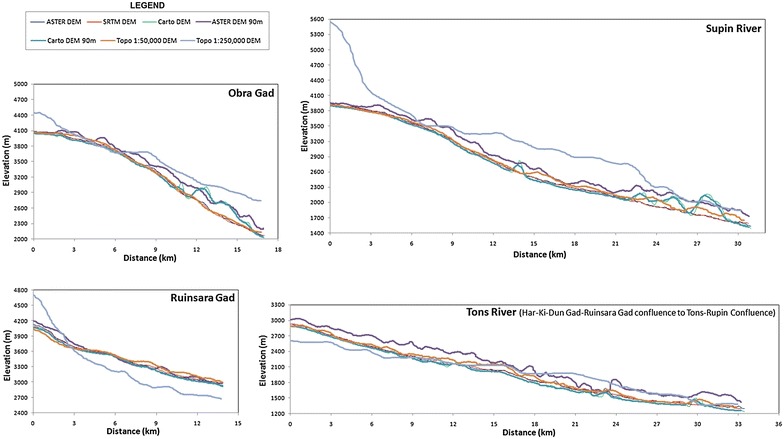
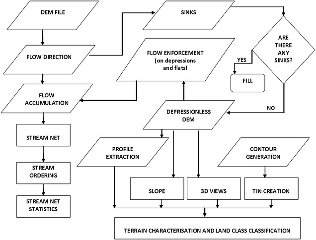
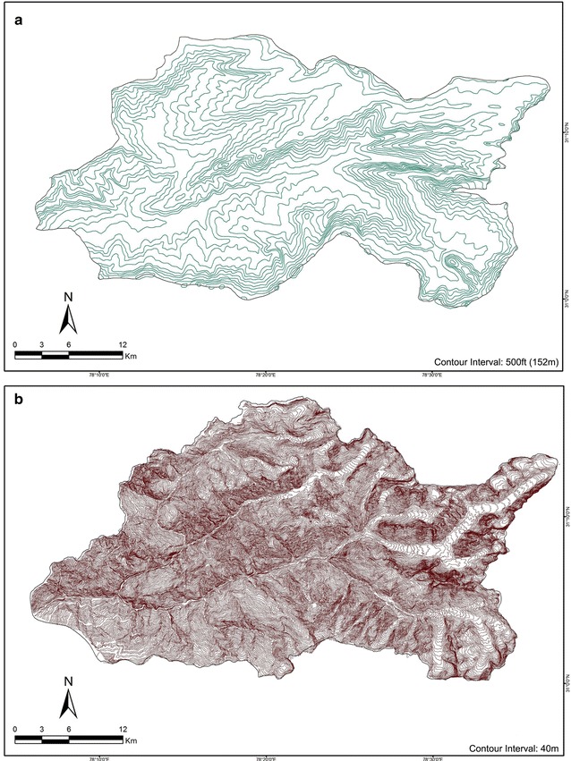
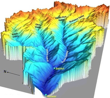
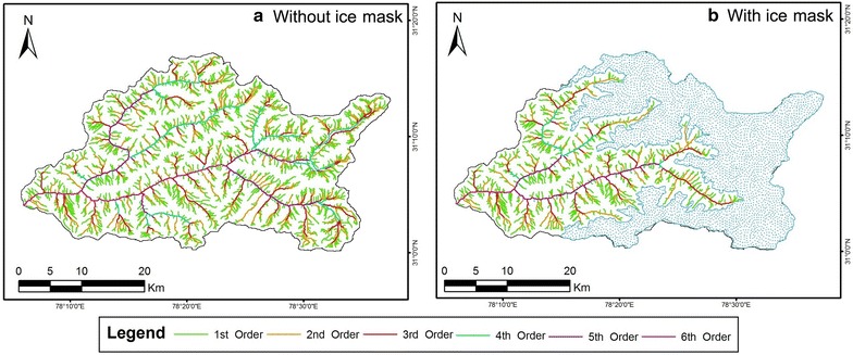
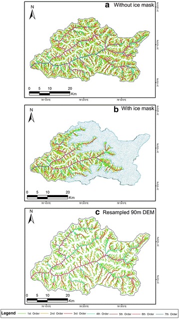
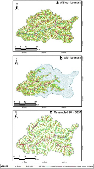
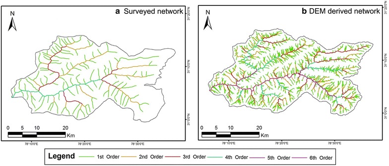
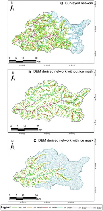
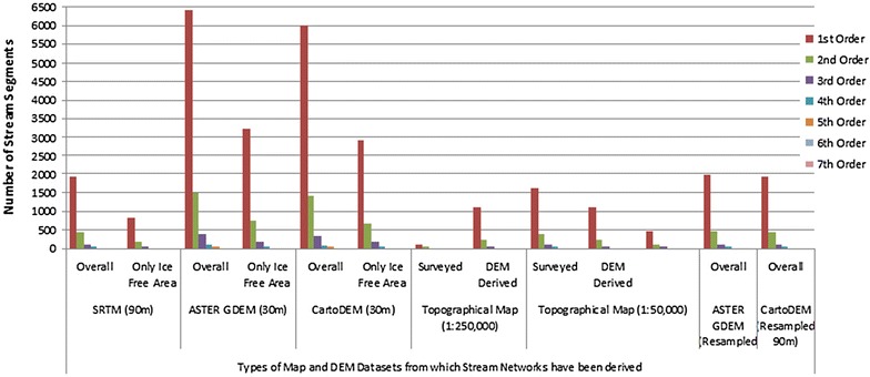
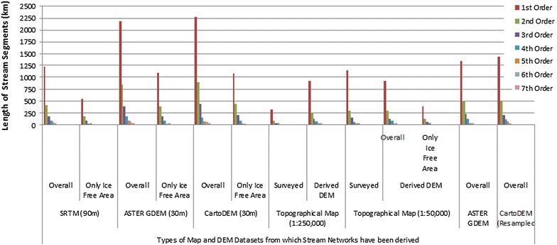
Nestled inside a mountainous setting, the basin is a semi-elongated one with high relief ratio (>90), steep slopes (25°-30°) and high drainage density (>3.5 km/sq km), as computed from the different DEMs. The basin terrain and stream network is extracted from each DEM, whose morphometric attributes are compared with the surveyed stream networks present in the topographical maps, with resampling of finer DEM datasets to coarser resolutions, to reduce scale-implications during the delineation process. Ground truth verifications for altitudinal accuracy have also been done by a GPS survey.

CONCLUSIONS

DEMs derived from the 1:50,000 topographical map and ASTER GDEM V2 data are found to be more accurate and consistent in terms of absolute accuracy, than the other generated or available DEM data products, on basis of the morphometric parameters extracted from each. They also exhibit a certain degree of proximity to the surveyed topographical map.

摘要

背景

随着现在有大量地理空间数据集可用于地形信息提取,尤其是流线划分,出现了关于从中得出这些方面的初始数据集的规模、准确性和敏感性的问题,因为它们会影响随后计算的所有其他参数。在本研究中,源自先进星载热发射和反射辐射计(ASTER V2)、航天飞机雷达地形测绘任务(SRTM V4,C波段,3弧秒)、Cartosat -1(CartoDEM 1.0)和地形图(比例尺1:250,000和1:50,000)的数字高程模型(DEM)已被分别用于提取和分析一个山区流域的地形起伏、地表、大小、形状和纹理属性。

结果

该流域位于山区内,从不同的DEM计算得出,它是一个半拉长的流域,地形起伏比率高(>90),坡度陡峭(25° - 30°),排水密度高(>3.5平方公里/平方公里)。从每个DEM中提取流域地形和水系网络,并将其形态测量属性与地形图中现有的实测水系网络进行比较,将更精细的DEM数据集重采样到更粗的分辨率,以减少划定过程中的尺度影响。还通过GPS测量对海拔高度准确性进行了实地验证。

结论

根据从每个DEM提取的形态测量参数,发现源自1:50,000地形图和ASTER GDEM V2数据的DEM在绝对准确性方面比其他生成的或可用的DEM数据产品更准确、更一致。它们也与实测地形图有一定程度的接近度。

https://cdn.ncbi.nlm.nih.gov/pmc/blobs/d288/5020020/40c8aefae136/40064_2016_3207_Fig12_HTML.jpg
https://cdn.ncbi.nlm.nih.gov/pmc/blobs/d288/5020020/769173080b43/40064_2016_3207_Fig1_HTML.jpg
https://cdn.ncbi.nlm.nih.gov/pmc/blobs/d288/5020020/30ebf4710c55/40064_2016_3207_Fig2_HTML.jpg
https://cdn.ncbi.nlm.nih.gov/pmc/blobs/d288/5020020/814814ba6b5c/40064_2016_3207_Fig3_HTML.jpg
https://cdn.ncbi.nlm.nih.gov/pmc/blobs/d288/5020020/e074ca4e4c30/40064_2016_3207_Fig4_HTML.jpg
https://cdn.ncbi.nlm.nih.gov/pmc/blobs/d288/5020020/2a148e2b902a/40064_2016_3207_Fig5_HTML.jpg
https://cdn.ncbi.nlm.nih.gov/pmc/blobs/d288/5020020/d27876eb65e6/40064_2016_3207_Fig6_HTML.jpg
https://cdn.ncbi.nlm.nih.gov/pmc/blobs/d288/5020020/9063255b2e19/40064_2016_3207_Fig7_HTML.jpg
https://cdn.ncbi.nlm.nih.gov/pmc/blobs/d288/5020020/ee0b593c1c56/40064_2016_3207_Fig8_HTML.jpg
https://cdn.ncbi.nlm.nih.gov/pmc/blobs/d288/5020020/7446b014b7a8/40064_2016_3207_Fig9_HTML.jpg
https://cdn.ncbi.nlm.nih.gov/pmc/blobs/d288/5020020/0088d866bd57/40064_2016_3207_Fig10_HTML.jpg
https://cdn.ncbi.nlm.nih.gov/pmc/blobs/d288/5020020/e87c5e0b4a98/40064_2016_3207_Fig11_HTML.jpg
https://cdn.ncbi.nlm.nih.gov/pmc/blobs/d288/5020020/40c8aefae136/40064_2016_3207_Fig12_HTML.jpg

相似文献

1
Evaluation of different digital elevation models for analyzing drainage morphometric parameters in a mountainous terrain: a case study of the Supin-Upper Tons Basin, Indian Himalayas.评估不同数字高程模型以分析山区地形的排水形态测量参数:以印度喜马拉雅山脉苏平-上通斯河流域为例
Springerplus. 2016 Sep 13;5(1):1544. doi: 10.1186/s40064-016-3207-0. eCollection 2016.
2
Data on comparative studies of lineaments extraction from ASTER DEM, SRTM, and Cartosat for Jilledubanderu River basin, Anantapur district, A.P, India by using remote sensing and GIS.关于利用遥感和地理信息系统对印度安得拉邦阿南塔布尔区吉勒杜班德鲁河流域的高级星载热辐射反射辐射计数字高程模型(ASTER DEM)、航天飞机雷达地形测绘任务(SRTM)和制图卫星数据进行地貌特征提取的对比研究数据。
Data Brief. 2018 Sep 11;20:1676-1682. doi: 10.1016/j.dib.2018.09.023. eCollection 2018 Oct.
3
Evaluation of the Vertical Accuracy of Open Global DEMs over Steep Terrain Regions Using ICESat Data: A Case Study over Hunan Province, China.利用ICESat数据评估陡峭地形区域开放全球数字高程模型的垂直精度:以中国湖南省为例
Sensors (Basel). 2020 Aug 28;20(17):4865. doi: 10.3390/s20174865.
4
Effect of Topographic Data Accuracy on Watershed Management.地形数据精度对流域管理的影响。
Int J Environ Res Public Health. 2019 Nov 1;16(21):4245. doi: 10.3390/ijerph16214245.
5
Prioritization of the micro-watersheds through morphometric analysis in the Vasishta Sub Basin of the Vellar River, Tamil Nadu using ASTER Digital Elevation Model (DEM) data.利用ASTER数字高程模型(DEM)数据,通过形态测量分析对泰米尔纳德邦韦拉尔河瓦西什塔子流域的微型流域进行优先级划分。
Data Brief. 2018 Sep 5;20:1353-1359. doi: 10.1016/j.dib.2018.08.197. eCollection 2018 Oct.
6
Digital elevation modelling using ASTER stereo imagery.利用高级星载热辐射反射辐射计(ASTER)立体图像进行数字高程建模。
J Environ Sci Eng. 2010 Apr;52(2):81-92.
7
Geospatial approaches of TGSI and morphometric analysis in the Mahi River basin using Landsat 8 OLI/TIRS and SRTM-DEM.利用 Landsat 8 OLI/TIRS 和 SRTM-DEM 进行 TGSI 的地理空间方法和形态计量分析在马希河流域。
Environ Sci Pollut Res Int. 2024 Sep;31(41):54129-54146. doi: 10.1007/s11356-022-24863-z. Epub 2022 Dec 23.
8
An Assessment of the Altimetric Information Derived from Spaceborne SAR (RADARSAT-1, SRTM3) and Optical (ASTER) Data for Cartographic Application in the Amazon Region.对源自星载合成孔径雷达(RADARSAT - 1、SRTM3)和光学(ASTER)数据的测高信息用于亚马逊地区制图应用的评估。
Sensors (Basel). 2008 Jun 6;8(6):3819-3829. doi: 10.3390/s8063819.
9
Investigation of potential sea level rise impact on the Nile Delta, Egypt using digital elevation models.利用数字高程模型研究海平面上升对埃及尼罗河三角洲的潜在影响。
Environ Monit Assess. 2015 Oct;187(10):649. doi: 10.1007/s10661-015-4868-9. Epub 2015 Sep 27.
10
Suitability of open-access elevation models for micro-scale watershed planning.开放获取高程模型在微尺度流域规划中的适用性。
Environ Monit Assess. 2018 Aug 10;190(9):512. doi: 10.1007/s10661-018-6890-1.

引用本文的文献

1
Impact of identical digital elevation model resolution and sources on morphometric parameters of Tena watershed, Ethiopia.相同数字高程模型分辨率和数据源对埃塞俄比亚特娜流域形态测量参数的影响
Heliyon. 2021 Nov 10;7(11):e08345. doi: 10.1016/j.heliyon.2021.e08345. eCollection 2021 Nov.

本文引用的文献

1
Optimality approaches to describe characteristic fluvial patterns on landscapes.用最优化方法描述景观中的特征河流模式。
Philos Trans R Soc Lond B Biol Sci. 2010 May 12;365(1545):1387-95. doi: 10.1098/rstb.2009.0303.