Van Leeuwen Willem J D
Department of Geography and Regional Development and the Office of Arid Lands Studies, 1955 E. Sixth Street, The University of Arizona, Tucson, AZ 85721, USA.
Sensors (Basel). 2008 Mar 25;8(3):2017-2042. doi: 10.3390/s8032017.
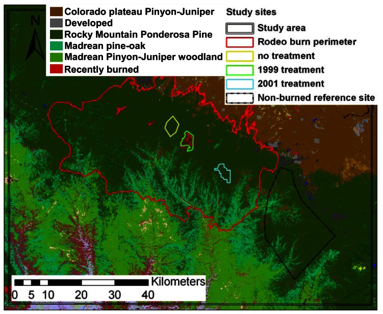
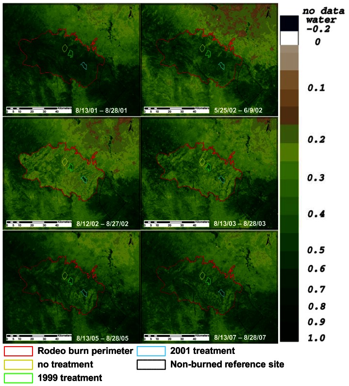
This study examines how satellite based time-series vegetation greenness data and phenological measurements can be used to monitor and quantify vegetation recovery after wildfire disturbances and examine how pre-fire fuel reduction restoration treatments impact fire severity and impact vegetation recovery trajectories. Pairs of wildfire affected sites and a nearby unburned reference site were chosen to measure the post-disturbance recovery in relation to climate variation. All site pairs were chosen in forested uplands in Arizona and were restricted to the area of the Rodeo-Chediski fire that occurred in 2002. Fuel reduction treatments were performed in 1999 and 2001. The inter-annual and seasonal vegetation dynamics before, during, and after wildfire events can be monitored using a time series of biweekly composited MODIS NDVI (Moderate Resolution Imaging Spectroradiometer - Normalized Difference Vegetation Index) data. Time series analysis methods included difference metrics, smoothing filters, and fitting functions that were applied to extract seasonal and inter-annual change and phenological metrics from the NDVI time series data from 2000 to 2007. Pre- and post-fire Landsat data were used to compute the Normalized Burn Ratio (NBR) and examine burn severity at the selected sites. The phenological metrics (pheno-metrics) included the timing and greenness (i.e. NDVI) for the start, peak and end of the growing season as well as proxy measures for the rate of green-up and senescence and the annual vegetation productivity. Pre-fire fuel reduction treatments resulted in lower fire severity, which reduced annual productivity much less than untreated areas within the Rodeo-Chediski fire perimeter. The seasonal metrics were shown to be useful for estimating the rate of post-fire disturbance recovery and the timing of phenological greenness phases. The use of satellite time series NDVI data and derived pheno-metrics show potential for tracking vegetation cover dynamics and successional changes in response to drought, wildfire disturbances, and forest restoration treatments in fire-suppressed forests.
本研究探讨了基于卫星的时间序列植被绿度数据和物候测量如何用于监测和量化野火干扰后的植被恢复情况,并研究火灾前的燃料减少恢复处理如何影响火灾严重程度以及植被恢复轨迹。选择了成对的受野火影响的地点和附近未燃烧的参考地点,以测量与气候变化相关的干扰后恢复情况。所有地点对均选在亚利桑那州的森林高地,且限于2002年发生的罗迪欧-切迪斯基火灾区域。燃料减少处理于1999年和2001年进行。利用双周合成的中分辨率成像光谱仪归一化植被指数(MODIS NDVI)数据的时间序列,可以监测野火事件之前、期间和之后的年际和季节植被动态。时间序列分析方法包括差异度量、平滑滤波器和拟合函数,应用这些方法从2000年至2007年NDVI时间序列数据中提取季节和年际变化以及物候度量。利用火灾前后的陆地卫星数据计算归一化燃烧比(NBR),并检查选定地点的燃烧严重程度。物候度量(物候指标)包括生长季开始、峰值和结束时的时间和绿度(即NDVI),以及绿度增加和衰老速率及年植被生产力的替代指标。火灾前的燃料减少处理导致火灾严重程度降低,与罗迪欧-切迪斯基火灾范围内未处理区域相比,年生产力的降低幅度要小得多。季节度量被证明有助于估计火灾后干扰恢复的速率和物候绿度阶段时间。利用卫星时间序列NDVI数据和导出的物候指标显示出在跟踪植被覆盖动态以及受火灾抑制森林中响应干旱、野火干扰和森林恢复处理的演替变化方面具有潜力。