• 文献检索
  • 文档翻译
  • 深度研究
  • 学术资讯
  • Suppr Zotero 插件Zotero 插件
  • 邀请有礼
  • 套餐&价格
  • 历史记录
应用&插件
Suppr Zotero 插件Zotero 插件浏览器插件Mac 客户端Windows 客户端微信小程序
定价
高级版会员购买积分包购买API积分包
服务
文献检索文档翻译深度研究API 文档MCP 服务
关于我们
关于 Suppr公司介绍联系我们用户协议隐私条款
关注我们

Suppr 超能文献

核心技术专利:CN118964589B侵权必究
粤ICP备2023148730 号-1Suppr @ 2026

文献检索

告别复杂PubMed语法,用中文像聊天一样搜索,搜遍4000万医学文献。AI智能推荐,让科研检索更轻松。

立即免费搜索

文件翻译

保留排版,准确专业,支持PDF/Word/PPT等文件格式,支持 12+语言互译。

免费翻译文档

深度研究

AI帮你快速写综述,25分钟生成高质量综述,智能提取关键信息,辅助科研写作。

立即免费体验

利用无人机系统(UAS)和热成像技术自动检测和计数海洋野生动物。

Automated detection and enumeration of marine wildlife using unmanned aircraft systems (UAS) and thermal imagery.

机构信息

Division of Marine Science and Conservation, Nicholas School of the Environment, Duke University Marine Laboratory, 135 Duke Marine Lab Rd, Beaufort, NC 28516, USA.

Peches et Oceans Canada/Fisheries and Oceans Canada. Institut Maurice-Lamontagne/Maurice Lamontagne Institute, C.P. 1000/P.O. Box 1000 850 Route de la Mer Mont-Joli, QC, G5H 3Z4, Canada.

出版信息

Sci Rep. 2017 Mar 24;7:45127. doi: 10.1038/srep45127.

DOI:10.1038/srep45127
PMID:28338047
原文链接:https://pmc.ncbi.nlm.nih.gov/articles/PMC5364474/
Abstract

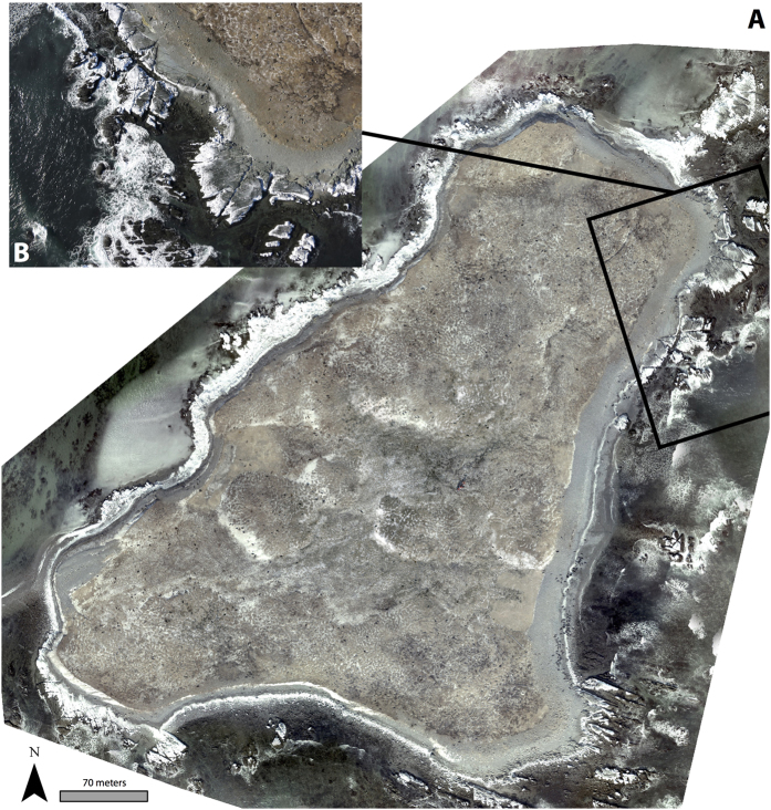
Estimating animal populations is critical for wildlife management. Aerial surveys are used for generating population estimates, but can be hampered by cost, logistical complexity, and human risk. Additionally, human counts of organisms in aerial imagery can be tedious and subjective. Automated approaches show promise, but can be constrained by long setup times and difficulty discriminating animals in aggregations. We combine unmanned aircraft systems (UAS), thermal imagery and computer vision to improve traditional wildlife survey methods. During spring 2015, we flew fixed-wing UAS equipped with thermal sensors, imaging two grey seal (Halichoerus grypus) breeding colonies in eastern Canada. Human analysts counted and classified individual seals in imagery manually. Concurrently, an automated classification and detection algorithm discriminated seals based upon temperature, size, and shape of thermal signatures. Automated counts were within 95-98% of human estimates; at Saddle Island, the model estimated 894 seals compared to analyst counts of 913, and at Hay Island estimated 2188 seals compared to analysts' 2311. The algorithm improves upon shortcomings of computer vision by effectively recognizing seals in aggregations while keeping model setup time minimal. Our study illustrates how UAS, thermal imagery, and automated detection can be combined to efficiently collect population data critical to wildlife management.

摘要

估算动物种群数量对于野生动物管理至关重要。航空调查被用于生成种群估计值,但可能受到成本、后勤复杂性和人员风险的限制。此外,在航空图像中对生物进行人工计数可能既繁琐又主观。自动化方法显示出前景,但可能受到设置时间长和难以区分聚集动物的限制。我们结合了无人机系统(UAS)、热成像和计算机视觉,以改进传统的野生动物调查方法。在 2015 年春季,我们飞行了配备热传感器的固定翼 UAS,对加拿大东部的两个灰海豹(Halichoerus grypus)繁殖地进行了成像。人类分析员手动对图像中的个体海豹进行计数和分类。同时,一种自动化分类和检测算法根据海豹的温度、大小和热特征形状来区分海豹。自动计数与人工估计值的误差在 95-98%之间;在马鞍岛,模型估计有 894 只海豹,而分析员的估计数为 913 只;在海伊岛,模型估计有 2188 只海豹,而分析员的估计数为 2311 只。该算法通过有效地识别聚集中的海豹,同时将模型设置时间保持在最小,克服了计算机视觉的缺点。我们的研究说明了如何结合无人机系统、热成像和自动检测来高效地收集对野生动物管理至关重要的种群数据。

https://cdn.ncbi.nlm.nih.gov/pmc/blobs/425e/5364474/d1f205454bd1/srep45127-f5.jpg
https://cdn.ncbi.nlm.nih.gov/pmc/blobs/425e/5364474/5b3d92d2b653/srep45127-f1.jpg
https://cdn.ncbi.nlm.nih.gov/pmc/blobs/425e/5364474/82bc47e5ce61/srep45127-f2.jpg
https://cdn.ncbi.nlm.nih.gov/pmc/blobs/425e/5364474/f5d749bb5e46/srep45127-f3.jpg
https://cdn.ncbi.nlm.nih.gov/pmc/blobs/425e/5364474/d2c44d2ac5e6/srep45127-f4.jpg
https://cdn.ncbi.nlm.nih.gov/pmc/blobs/425e/5364474/d1f205454bd1/srep45127-f5.jpg

相似文献

1
Automated detection and enumeration of marine wildlife using unmanned aircraft systems (UAS) and thermal imagery.利用无人机系统(UAS)和热成像技术自动检测和计数海洋野生动物。
Sci Rep. 2017 Mar 24;7:45127. doi: 10.1038/srep45127.
2
Assessing the disturbance potential of small unoccupied aircraft systems (UAS) on gray seals () at breeding colonies in Nova Scotia, Canada.评估小型无人飞行器系统(UAS)对加拿大新斯科舍省繁殖地的灰海豹()的干扰可能性。
PeerJ. 2018 Mar 19;6:e4467. doi: 10.7717/peerj.4467. eCollection 2018.
3
Remote sensing techniques for automated marine mammals detection: a review of methods and current challenges.遥感技术在自动海洋哺乳动物检测中的应用:方法综述及当前挑战。
PeerJ. 2022 Jun 20;10:e13540. doi: 10.7717/peerj.13540. eCollection 2022.
4
Unoccupied Aircraft Systems in Marine Science and Conservation.无人航空系统在海洋科学与保护中的应用。
Ann Rev Mar Sci. 2019 Jan 3;11:439-463. doi: 10.1146/annurev-marine-010318-095323. Epub 2018 Jul 18.
5
Google Haul Out: Earth Observation Imagery and Digital Aerial Surveys in Coastal Wildlife Management and Abundance Estimation.谷歌数据提取:地球观测图像与数字航空测量在沿海野生动物管理及数量估计中的应用
Bioscience. 2017 Aug 1;67(8):760-768. doi: 10.1093/biosci/bix059. Epub 2017 Jun 14.
6
Integrating satellite and unmanned aircraft system (UAS) imagery to model livestock population dynamics in the Longbao Wetland National Nature Reserve, China.整合卫星和无人机系统 (UAS) 图像来模拟中国龙宝湿地国家级自然保护区的牲畜种群动态。
Sci Total Environ. 2020 Dec 1;746:140327. doi: 10.1016/j.scitotenv.2020.140327. Epub 2020 Jun 20.
7
Evidence on the efficacy of small unoccupied aircraft systems (UAS) as a survey tool for North American terrestrial, vertebrate animals: a systematic map.关于小型无人航空器系统(UAS)作为北美陆地脊椎动物调查工具的功效的证据:一项系统综述。
Environ Evid. 2023 Feb 13;12(1):3. doi: 10.1186/s13750-022-00294-8.
8
Airborne Optical and Thermal Remote Sensing for Wildfire Detection and Monitoring.用于野火探测与监测的机载光学和热遥感
Sensors (Basel). 2016 Aug 18;16(8):1310. doi: 10.3390/s16081310.
9
Unmanned aerial vehicles for surveying marine fauna: assessing detection probability.用于调查海洋动物群的无人机:评估检测概率。
Ecol Appl. 2017 Jun;27(4):1253-1267. doi: 10.1002/eap.1519. Epub 2017 Apr 17.
10
Temperature effects on the breeding distribution of grey seals (Halichoerus grypus).温度对灰海豹(Halichoerus grypus)繁殖分布的影响。
Physiol Zool. 1997 Jul-Aug;70(4):436-43. doi: 10.1086/515849.

引用本文的文献

1
Evaluation of Automated Object-Detection Algorithms for Koala Detection in Infrared Aerial Imagery.评估用于红外航空图像中树袋熊检测的自动目标检测算法。
Sensors (Basel). 2024 Oct 31;24(21):7048. doi: 10.3390/s24217048.
2
Heating decoys to mimic thermal signatures of live animals for drones.加热诱饵以模拟无人机可探测到的活体动物的热信号。
MethodsX. 2024 Aug 30;13:102933. doi: 10.1016/j.mex.2024.102933. eCollection 2024 Dec.
3
Evaluating Thermal Infrared Drone Flight Parameters on Spider Monkey Detection in Tropical Forests.评估热红外无人机在热带雨林中对蜘蛛猴检测的飞行参数。

本文引用的文献

1
Unmanned Aerial Vehicles (UAVs) and Artificial Intelligence Revolutionizing Wildlife Monitoring and Conservation.无人机与人工智能正在彻底改变野生动物监测与保护工作。
Sensors (Basel). 2016 Jan 14;16(1):97. doi: 10.3390/s16010097.
2
Trends in Stranding and By-Catch Rates of Gray and Harbor Seals along the Northeastern Coast of the United States: Evidence of Divergence in the Abundance of Two Sympatric Phocid Species?美国东北海岸灰海豹和港海豹搁浅及兼捕率的趋势:两种同域海豹科物种数量分化的证据?
PLoS One. 2015 Jul 22;10(7):e0131660. doi: 10.1371/journal.pone.0131660. eCollection 2015.
3
Lifting baselines to address the consequences of conservation success.
Sensors (Basel). 2024 Aug 30;24(17):5659. doi: 10.3390/s24175659.
4
Aerial Wildlife Image Repository for animal monitoring with drones in the age of artificial intelligence.人工智能时代,用于无人机动物监测的空中野生动物图像库。
Database (Oxford). 2024 Jul 23;2024. doi: 10.1093/database/baae070.
5
Airborne imagery does not preclude detectability issues in estimating bird colony size.航空图像并不会排除在估算鸟类聚居地规模时出现的可探测性问题。
Sci Rep. 2024 Feb 14;14(1):3673. doi: 10.1038/s41598-024-53961-w.
6
Utility of Spectral Filtering to Improve the Reliability of Marine Fauna Detections from Drone-Based Monitoring.光谱滤波在提高基于无人机监测的海洋动物检测可靠性方面的应用。
Sensors (Basel). 2023 Nov 15;23(22):9193. doi: 10.3390/s23229193.
7
Fusion of visible and thermal images improves automated detection and classification of animals for drone surveys.可见光和热图像融合可提高无人机调查中动物自动检测和分类的精度。
Sci Rep. 2023 Jun 27;13(1):10385. doi: 10.1038/s41598-023-37295-7.
8
The broad scale impact of climate change on planning aerial wildlife surveys with drone-based thermal cameras.气候变化对基于无人机热成像技术的空中野生动物调查规划的广泛影响。
Sci Rep. 2023 Mar 17;13(1):4455. doi: 10.1038/s41598-023-31150-5.
9
Experimental verification of seafloor crustal deformation observations by UAV-based GNSS-A.基于无人机 GNSS-A 的海底地壳变形观测的实验验证。
Sci Rep. 2023 Mar 13;13(1):4105. doi: 10.1038/s41598-023-31214-6.
10
Artificial intelligence for automated detection of large mammals creates path to upscale drone surveys.人工智能助力大型哺乳动物自动检测,推动无人机调查升级。
Sci Rep. 2023 Jan 18;13(1):947. doi: 10.1038/s41598-023-28240-9.
提升基准线以应对保护成功的后果。
Trends Ecol Evol. 2015 Jun;30(6):299-302. doi: 10.1016/j.tree.2015.04.003.
4
Population census of a large common tern colony with a small unmanned aircraft.使用小型无人机对大型普通燕鸥栖息地进行种群普查。
PLoS One. 2015 Apr 15;10(4):e0122588. doi: 10.1371/journal.pone.0122588. eCollection 2015.
5
Satellites, the all-seeing eyes in the sky: counting elephant seals from space.卫星,天空中的全方位之眼:从太空计数象海豹。
PLoS One. 2014 Mar 20;9(3):e92613. doi: 10.1371/journal.pone.0092613. eCollection 2014.
6
Unmanned aerial vehicles (UAVs) for surveying marine fauna: a dugong case study.用于海洋动物调查的无人机:儒艮案例研究。
PLoS One. 2013 Nov 4;8(11):e79556. doi: 10.1371/journal.pone.0079556. eCollection 2013.
7
Mark-recapture with multiple, non-invasive marks.使用多种非侵入性标记进行标记重捕法。
Biometrics. 2013 Sep;69(3):766-75. doi: 10.1111/biom.12045. Epub 2013 Jul 11.
8
Ecological community description using the food web, species abundance, and body size.利用食物网、物种丰度和体型进行生态群落描述。
Proc Natl Acad Sci U S A. 2003 Feb 18;100(4):1781-6. doi: 10.1073/pnas.232715699. Epub 2003 Jan 23.