• 文献检索
  • 文档翻译
  • 深度研究
  • 学术资讯
  • Suppr Zotero 插件Zotero 插件
  • 邀请有礼
  • 套餐&价格
  • 历史记录
应用&插件
Suppr Zotero 插件Zotero 插件浏览器插件Mac 客户端Windows 客户端微信小程序
定价
高级版会员购买积分包购买API积分包
服务
文献检索文档翻译深度研究API 文档MCP 服务
关于我们
关于 Suppr公司介绍联系我们用户协议隐私条款
关注我们

Suppr 超能文献

核心技术专利:CN118964589B侵权必究
粤ICP备2023148730 号-1Suppr @ 2026

文献检索

告别复杂PubMed语法,用中文像聊天一样搜索,搜遍4000万医学文献。AI智能推荐,让科研检索更轻松。

立即免费搜索

文件翻译

保留排版,准确专业,支持PDF/Word/PPT等文件格式,支持 12+语言互译。

免费翻译文档

深度研究

AI帮你快速写综述,25分钟生成高质量综述,智能提取关键信息,辅助科研写作。

立即免费体验

比较基于像素和基于对象的方法来绘制热带混交林下木层入侵灌木分布图

Comparing Pixel and Object-Based Approaches to Map an Understorey Invasive Shrub in Tropical Mixed Forests.

作者信息

Niphadkar Madhura, Nagendra Harini, Tarantino Cristina, Adamo Maria, Blonda Palma

机构信息

Ashoka Trust for Research in Ecology and the EnvironmentBangalore, India.

Manipal UniversityManipal, India.

出版信息

Front Plant Sci. 2017 May 31;8:892. doi: 10.3389/fpls.2017.00892. eCollection 2017.

DOI:10.3389/fpls.2017.00892
PMID:28620400
原文链接:https://pmc.ncbi.nlm.nih.gov/articles/PMC5450565/
Abstract

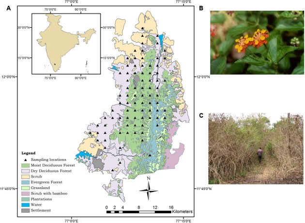
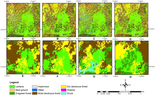
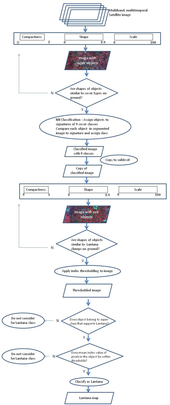
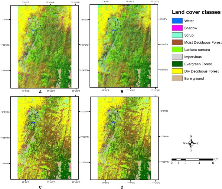
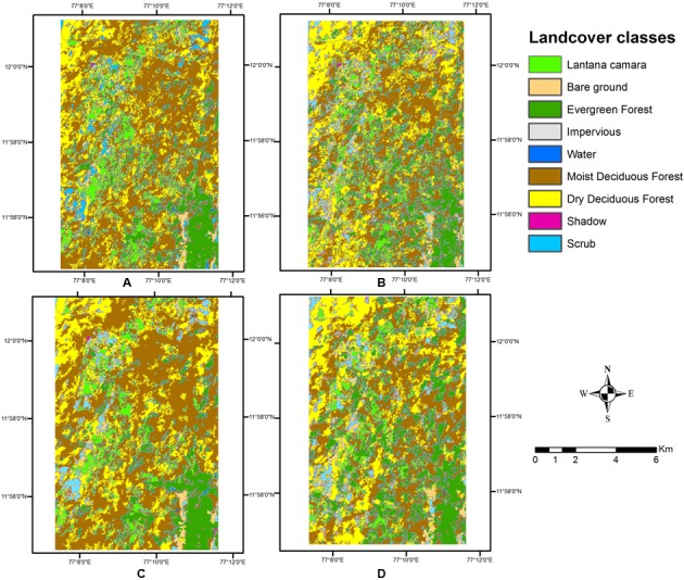
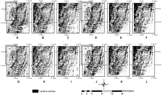
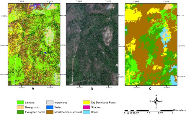
The establishment of invasive alien species in varied habitats across the world is now recognized as a genuine threat to the preservation of biodiversity. Specifically, plant invasions in understory tropical forests are detrimental to the persistence of healthy ecosystems. Monitoring such invasions using Very High Resolution (VHR) satellite remote sensing has been shown to be valuable in designing management interventions for conservation of native habitats. Object-based classification methods are very helpful in identifying invasive plants in various habitats, by their inherent nature of imitating the ability of the human brain in pattern recognition. However, these methods have not been tested adequately in dense tropical mixed forests where invasion occurs in the understorey. This study compares a pixel-based and object-based classification method for mapping the understorey invasive shrub () in a tropical mixed forest habitat in the Western Ghats biodiversity hotspot in India. Overall, a hierarchical approach of mapping top canopy at first, and then further processing for the understorey shrub, using measures such as texture and vegetation indices proved effective in separating out from other cover types. In the first method, we implement a simple parametric supervised classification for mapping cover types, and then process within these types for delineation. In the second method, we use an object-based segmentation algorithm to map cover types, and then perform further processing for separating . The improved ability of the object-based approach to delineate structurally distinct objects with characteristic spectral and spatial characteristics of their own, as well as with reference to their surroundings, allows for much flexibility in identifying invasive understorey shrubs among the complex vegetation of the tropical forest than that provided by the parametric classifier. Conservation practices in tropical mixed forests can benefit greatly by adopting methods which use high resolution remotely sensed data and advanced techniques to monitor the patterns and effective functioning of native ecosystems by periodically mapping disturbances such as invasion.

摘要

外来入侵物种在世界各地不同栖息地的定殖,如今已被公认为是对生物多样性保护的一种切实威胁。具体而言,热带林下森林中的植物入侵对健康生态系统的持续存在不利。利用甚高分辨率(VHR)卫星遥感监测此类入侵,已证明在设计保护原生栖息地的管理干预措施方面具有重要价值。基于对象的分类方法在识别各种栖息地中的入侵植物方面非常有帮助,因为其本质上能够模仿人类大脑的模式识别能力。然而,这些方法在热带茂密混交林的林下入侵区域尚未得到充分测试。本研究比较了基于像元和基于对象的分类方法,用于绘制印度西高止山脉生物多样性热点地区热带混交林栖息地林下入侵灌木()的分布图。总体而言,首先绘制顶级树冠层,然后使用纹理和植被指数等措施对林下灌木进行进一步处理的分层方法,在将与其他覆盖类型区分开来方面证明是有效的。在第一种方法中,我们实施一种简单的参数化监督分类来绘制覆盖类型,然后在这些类型中进行处理以进行的 delineation。在第二种方法中,我们使用基于对象的分割算法来绘制覆盖类型,然后进行进一步处理以分离。基于对象的方法能够更好地描绘具有自身特征光谱和空间特征以及参考其周围环境的结构上不同的对象,这使得在热带森林复杂植被中识别林下入侵灌木时比参数分类器具有更大的灵活性。通过采用利用高分辨率遥感数据和先进技术的方法,定期绘制诸如入侵等干扰情况,以监测原生生态系统的模式和有效功能,热带混交林的保护实践将受益匪浅。

https://cdn.ncbi.nlm.nih.gov/pmc/blobs/b476/5450565/74381d8c0d71/fpls-08-00892-g008.jpg
https://cdn.ncbi.nlm.nih.gov/pmc/blobs/b476/5450565/0f622febbd9e/fpls-08-00892-g001.jpg
https://cdn.ncbi.nlm.nih.gov/pmc/blobs/b476/5450565/c8cec7f5e9a2/fpls-08-00892-g002.jpg
https://cdn.ncbi.nlm.nih.gov/pmc/blobs/b476/5450565/b11e69125b75/fpls-08-00892-g003.jpg
https://cdn.ncbi.nlm.nih.gov/pmc/blobs/b476/5450565/cea90bfb5213/fpls-08-00892-g004.jpg
https://cdn.ncbi.nlm.nih.gov/pmc/blobs/b476/5450565/7bf9ce0f154b/fpls-08-00892-g005.jpg
https://cdn.ncbi.nlm.nih.gov/pmc/blobs/b476/5450565/509ace73cdae/fpls-08-00892-g006.jpg
https://cdn.ncbi.nlm.nih.gov/pmc/blobs/b476/5450565/2897164c7ca0/fpls-08-00892-g007.jpg
https://cdn.ncbi.nlm.nih.gov/pmc/blobs/b476/5450565/74381d8c0d71/fpls-08-00892-g008.jpg

相似文献

1
Comparing Pixel and Object-Based Approaches to Map an Understorey Invasive Shrub in Tropical Mixed Forests.比较基于像素和基于对象的方法来绘制热带混交林下木层入侵灌木分布图
Front Plant Sci. 2017 May 31;8:892. doi: 10.3389/fpls.2017.00892. eCollection 2017.
2
Effects of an exotic plant invasion on native understory plants in a tropical dry forest.外来植物入侵对热带干旱森林本地林下植物的影响。
Conserv Biol. 2010 Jun;24(3):747-57. doi: 10.1111/j.1523-1739.2009.01420.x. Epub 2010 Jan 11.
3
Mapping multi-scale vascular plant richness in a forest landscape with integrated LiDAR and hyperspectral remote-sensing.利用综合激光雷达和高光谱遥感技术绘制森林景观中多尺度维管植物丰富度图谱。
Ecology. 2018 Feb;99(2):474-487. doi: 10.1002/ecy.2109.
4
Long-term environmental correlates of invasion by Lantana camara (Verbenaceae) in a seasonally dry tropical forest.长期的环境因素与马缨丹(马鞭草科)在季节性干燥热带森林中的入侵有关。
PLoS One. 2013 Oct 22;8(10):e76995. doi: 10.1371/journal.pone.0076995. eCollection 2013.
5
Exclusion of large herbivores affects understorey shrub vegetation more than herb vegetation across 147 forest sites in three German regions.在德国三个地区的 147 个森林样地中,大型食草动物的排除对林下灌木植被的影响大于草本植被。
PLoS One. 2019 Jul 10;14(7):e0218741. doi: 10.1371/journal.pone.0218741. eCollection 2019.
6
Opportunities and challenges in using remote sensing for invasive tree species management, and in the identification of restoration sites in tropical montane grasslands.利用遥感进行入侵树种管理以及识别热带山地草原恢复区的机会与挑战。
J Environ Manage. 2021 Feb 15;280:111759. doi: 10.1016/j.jenvman.2020.111759. Epub 2020 Dec 6.
7
Forest floor temperature and greenness link significantly to canopy attributes in South Africa's fragmented coastal forests.在南非破碎化的沿海森林中,林地温度和植被绿度与树冠层属性显著相关。
PeerJ. 2019 Jan 10;7:e6190. doi: 10.7717/peerj.6190. eCollection 2019.
8
Nationwide classification of forest types of India using remote sensing and GIS.利用遥感和地理信息系统对印度森林类型进行全国范围分类。
Environ Monit Assess. 2015 Dec;187(12):777. doi: 10.1007/s10661-015-4990-8. Epub 2015 Nov 28.
9
Lantana camara L. (Verbenaceae) invasion along streams in a heterogeneous landscape.马缨丹(马鞭草科)在异质景观中沿溪流的入侵。
J Biosci. 2014 Sep;39(4):717-26. doi: 10.1007/s12038-014-9465-5.
10
Patterns of understory invasion in invasive timber stands of a tropical sky island.热带天空岛屿入侵性木材林分的林下植被入侵模式。
Ecol Evol. 2023 Apr 13;13(4):e9995. doi: 10.1002/ece3.9995. eCollection 2023 Apr.

本文引用的文献

1
Modelling Hotspots for Invasive Alien Plants in India.印度外来入侵植物热点地区建模
PLoS One. 2015 Jul 31;10(7):e0134665. doi: 10.1371/journal.pone.0134665. eCollection 2015.
2
Monitoring the invasion of Spartina alterniflora using very high resolution unmanned aerial vehicle imagery in Beihai, Guangxi (China).利用超高分辨率无人机影像监测广西北海(中国)互花米草的入侵情况。
ScientificWorldJournal. 2014;2014:638296. doi: 10.1155/2014/638296. Epub 2014 May 4.
3
Detecting new Buffel grass infestations in Australian arid lands: evaluation of methods using high-resolution multispectral imagery and aerial photography.
检测澳大利亚干旱地区的新布菲利草丛蔓延:使用高分辨率多光谱图像和航空摄影评估方法。
Environ Monit Assess. 2014 Mar;186(3):1689-703. doi: 10.1007/s10661-013-3486-7.
4
Long-term environmental correlates of invasion by Lantana camara (Verbenaceae) in a seasonally dry tropical forest.长期的环境因素与马缨丹(马鞭草科)在季节性干燥热带森林中的入侵有关。
PLoS One. 2013 Oct 22;8(10):e76995. doi: 10.1371/journal.pone.0076995. eCollection 2013.
5
Spectral Discrimination of the Invasive Plant Spartina alterniflora at Multiple Phenological Stages in a Saltmarsh Wetland.盐沼湿地中互花米草多个物候期的光谱识别
PLoS One. 2013 Jun 27;8(6):e67315. doi: 10.1371/journal.pone.0067315. Print 2013.
6
A battle lost? Report on two centuries of invasion and management of Lantana camara L. in Australia, India and South Africa.输了一场战役?报告称,在澳大利亚、印度和南非,入侵和管理马缨丹(Lantana camara L.)已有两个世纪之久。
PLoS One. 2012;7(3):e32407. doi: 10.1371/journal.pone.0032407. Epub 2012 Mar 5.
7
Invasive plants transform the three-dimensional structure of rain forests.入侵植物改变了雨林的三维结构。
Proc Natl Acad Sci U S A. 2008 Mar 18;105(11):4519-23. doi: 10.1073/pnas.0710811105. Epub 2008 Mar 3.
8
A comparison of spatial and spectral image resolution for mapping invasive plants in coastal california.加利福尼亚海岸入侵植物绘图的空间和光谱图像分辨率比较
Environ Manage. 2007 Jan;39(1):63-83. doi: 10.1007/s00267-005-0228-9. Epub 2006 Nov 29.
9
Texture analysis for mapping Tamarix parviflora using aerial photographs along the Cache Creek, California.利用加利福尼亚州卡什溪沿岸的航空照片对小花柽柳进行纹理分析以绘制地图。
Environ Monit Assess. 2006 Mar;114(1-3):65-83. doi: 10.1007/s10661-006-1071-z. Epub 2006 Mar 29.