• 文献检索
  • 文档翻译
  • 深度研究
  • 学术资讯
  • Suppr Zotero 插件Zotero 插件
  • 邀请有礼
  • 套餐&价格
  • 历史记录
应用&插件
Suppr Zotero 插件Zotero 插件浏览器插件Mac 客户端Windows 客户端微信小程序
定价
高级版会员购买积分包购买API积分包
服务
文献检索文档翻译深度研究API 文档MCP 服务
关于我们
关于 Suppr公司介绍联系我们用户协议隐私条款
关注我们

Suppr 超能文献

核心技术专利:CN118964589B侵权必究
粤ICP备2023148730 号-1Suppr @ 2026

文献检索

告别复杂PubMed语法,用中文像聊天一样搜索,搜遍4000万医学文献。AI智能推荐,让科研检索更轻松。

立即免费搜索

文件翻译

保留排版,准确专业,支持PDF/Word/PPT等文件格式,支持 12+语言互译。

免费翻译文档

深度研究

AI帮你快速写综述,25分钟生成高质量综述,智能提取关键信息,辅助科研写作。

立即免费体验

一种用于高光谱热遥感的星基成像仪器概念。

A Satellite-Based Imaging Instrumentation Concept for Hyperspectral Thermal Remote Sensing.

作者信息

Udelhoven Thomas, Schlerf Martin, Segl Karl, Mallick Kaniska, Bossung Christian, Retzlaff Rebecca, Rock Gilles, Fischer Peter, Müller Andreas, Storch Tobias, Eisele Andreas, Weise Dennis, Hupfer Werner, Knigge Thiemo

机构信息

Department of Environmental Remote Sensing & Geoinformatics, University of Trier, 54286 Trier, Germany.

Luxembourg Institute of Science and Technology (LIST), L-4362 Esch-sur-Alzette, Luxembourg.

出版信息

Sensors (Basel). 2017 Jul 1;17(7):1542. doi: 10.3390/s17071542.

DOI:10.3390/s17071542
PMID:28671575
原文链接:https://pmc.ncbi.nlm.nih.gov/articles/PMC5539530/
Abstract

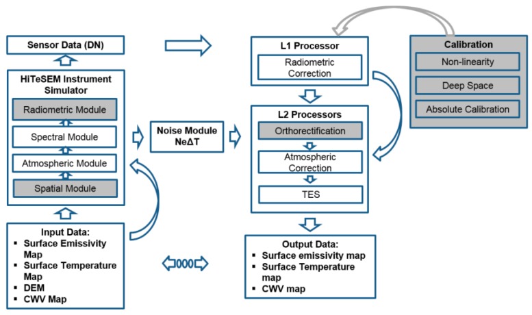
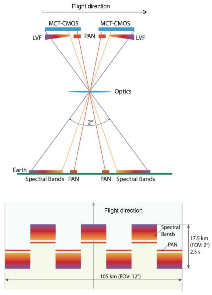
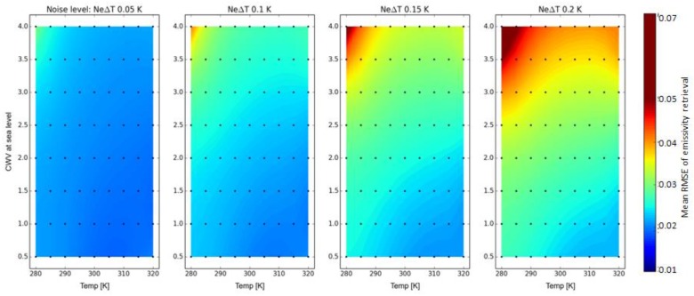
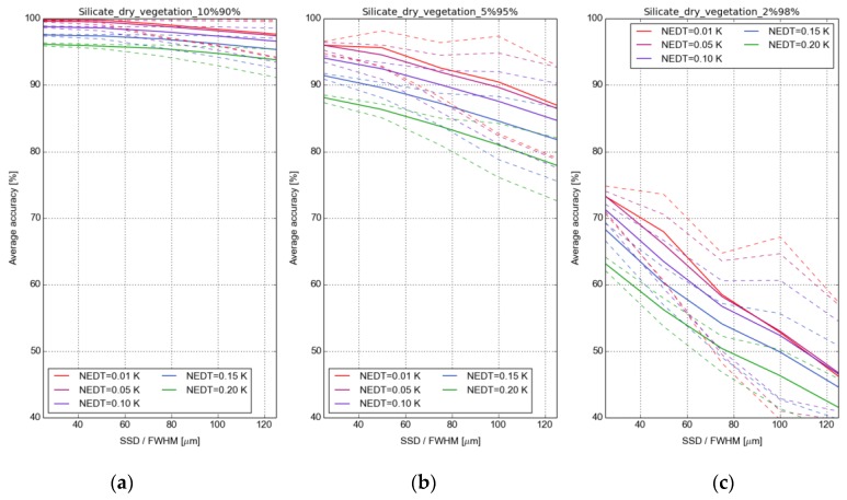
This paper describes the concept of the hyperspectral Earth-observing thermal infrared (TIR) satellite mission HiTeSEM (High-resolution Temperature and Spectral Emissivity Mapping). The scientific goal is to measure specific key variables from the biosphere, hydrosphere, pedosphere, and geosphere related to two global problems of significant societal relevance: food security and human health. The key variables comprise land and sea surface radiation temperature and emissivity, surface moisture, thermal inertia, evapotranspiration, soil minerals and grain size components, soil organic carbon, plant physiological variables, and heat fluxes. The retrieval of this information requires a TIR imaging system with adequate spatial and spectral resolutions and with day-night following observation capability. Another challenge is the monitoring of temporally high dynamic features like energy fluxes, which require adequate revisit time. The suggested solution is a sensor pointing concept to allow high revisit times for selected target regions (1-5 days at off-nadir). At the same time, global observations in the nadir direction are guaranteed with a lower temporal repeat cycle (>1 month). To account for the demand of a high spatial resolution for complex targets, it is suggested to combine in one optic (1) a hyperspectral TIR system with ~75 bands at 7.2-12.5 µm (instrument NEDT 0.05 K-0.1 K) and a ground sampling distance (GSD) of 60 m, and (2) a panchromatic high-resolution TIR-imager with two channels (8.0-10.25 µm and 10.25-12.5 µm) and a GSD of 20 m. The identified science case requires a good correlation of the instrument orbit with Sentinel-2 (maximum delay of 1-3 days) to combine data from the visible and near infrared (VNIR), the shortwave infrared (SWIR) and TIR spectral regions and to refine parameter retrieval.

摘要

本文介绍了高光谱地球观测热红外(TIR)卫星任务HiTeSEM(高分辨率温度和光谱发射率测绘)的概念。其科学目标是测量来自生物圈、水圈、土壤圈和地圈的特定关键变量,这些变量与具有重大社会意义的两个全球性问题相关:粮食安全和人类健康。关键变量包括陆地和海洋表面辐射温度及发射率、地表湿度、热惯性、蒸散、土壤矿物质和粒度成分、土壤有机碳、植物生理变量以及热通量。获取这些信息需要一个具有足够空间和光谱分辨率且具备昼夜连续观测能力的热红外成像系统。另一个挑战是监测像能量通量这样具有高时间动态性的特征,这需要足够的重访时间。建议的解决方案是一种传感器指向概念,以使选定目标区域具有高重访时间(偏离天底方向时为1 - 5天)。同时,天底方向的全球观测通过较低的时间重复周期(>1个月)得以保证。为满足复杂目标对高空间分辨率的需求,建议在一个光学系统中结合:(1)一个在7.2 - 12.5 µm波段有~75个波段(仪器噪声等效温差为0.05 K - 0.1 K)且地面采样距离(GSD)为60 m的高光谱热红外系统,以及(2)一个具有两个通道(8.0 - 10.25 µm和10.25 - 12.5 µm)且GSD为20 m的全色高分辨率热红外成像仪。已确定的科学案例要求仪器轨道与哨兵 - 2卫星具有良好的相关性(最大延迟为1 - 3天),以便合并来自可见光和近红外(VNIR)、短波红外(SWIR)和热红外光谱区域的数据,并优化参数反演。

https://cdn.ncbi.nlm.nih.gov/pmc/blobs/72e2/5539530/232fa0c3bfa7/sensors-17-01542-g007.jpg
https://cdn.ncbi.nlm.nih.gov/pmc/blobs/72e2/5539530/50b5556f8e4b/sensors-17-01542-g001.jpg
https://cdn.ncbi.nlm.nih.gov/pmc/blobs/72e2/5539530/038d891f57aa/sensors-17-01542-g002.jpg
https://cdn.ncbi.nlm.nih.gov/pmc/blobs/72e2/5539530/03d55a10b9ba/sensors-17-01542-g003.jpg
https://cdn.ncbi.nlm.nih.gov/pmc/blobs/72e2/5539530/6aac086c1c61/sensors-17-01542-g004.jpg
https://cdn.ncbi.nlm.nih.gov/pmc/blobs/72e2/5539530/8d063d7f678d/sensors-17-01542-g005.jpg
https://cdn.ncbi.nlm.nih.gov/pmc/blobs/72e2/5539530/0b3147efb37c/sensors-17-01542-g006.jpg
https://cdn.ncbi.nlm.nih.gov/pmc/blobs/72e2/5539530/232fa0c3bfa7/sensors-17-01542-g007.jpg

相似文献

1
A Satellite-Based Imaging Instrumentation Concept for Hyperspectral Thermal Remote Sensing.一种用于高光谱热遥感的星基成像仪器概念。
Sensors (Basel). 2017 Jul 1;17(7):1542. doi: 10.3390/s17071542.
2
[The progress in retrieving land surface temperature based on thermal infrared and microwave remote sensing technologies].基于热红外和微波遥感技术反演地表温度的研究进展
Guang Pu Xue Yu Guang Pu Fen Xi. 2009 Aug;29(8):2103-7.
3
Multi-source datasets acquired over Toulouse (France) in 2021 for urban microclimate studies during the CAMCATT/AI4GEO field campaign.2021年在法国图卢兹获取的多源数据集,用于CAMCATT/AI4GEO实地考察期间的城市微气候研究。
Data Brief. 2023 Apr 3;48:109109. doi: 10.1016/j.dib.2023.109109. eCollection 2023 Jun.
4
Mid-Infrared Emissivity Retrieval from Nighttime Sentinel-3 SLSTR Images Combining Split-Window Algorithms and the Radiance Transfer Method.从中红外发射率检索从夜间哨兵-3 SLSTR 图像结合分裂窗口算法和辐射传输方法。
Int J Environ Res Public Health. 2022 Dec 20;20(1):37. doi: 10.3390/ijerph20010037.
5
Retrieving Land Surface Temperature from Hyperspectral Thermal Infrared Data Using a Multi-Channel Method.使用多通道方法从高光谱热红外数据中反演地表温度
Sensors (Basel). 2016 May 13;16(5):687. doi: 10.3390/s16050687.
6
Estimation of evapotranspiration of temperate grassland based on high-resolution thermal and visible range imagery from unmanned aerial systems.基于无人机系统高分辨率热成像和可见光成像估算温带草原蒸散量
Int J Remote Sens. 2018 May 10;39(15-16):5141-5174. doi: 10.1080/01431161.2018.1471550. eCollection 2018.
7
Thermal and near infrared sensor for carbon observation Fourier-transform spectrometer on the Greenhouse Gases Observing Satellite for greenhouse gases monitoring.温室气体观测卫星上用于温室气体监测的碳观测傅里叶变换光谱仪的热红外和近红外传感器。
Appl Opt. 2009 Dec 10;48(35):6716-33. doi: 10.1364/AO.48.006716.
8
A Multi-Channel Method for Retrieving Surface Temperature for High-Emissivity Surfaces from Hyperspectral Thermal Infrared Images.一种从高光谱热红外图像中反演高发射率表面温度的多通道方法。
Sensors (Basel). 2015 Jun 8;15(6):13406-23. doi: 10.3390/s150613406.
9
Optimal Interpolation for Infrared Products from Hyperspectral Satellite Imagers and Sounders.高光谱卫星成像仪和探测器红外产品的最优插值
Sensors (Basel). 2020 Apr 21;20(8):2352. doi: 10.3390/s20082352.
10
[Monitoring the thermal plume from coastal nuclear power plant using satellite remote sensing data: modeling, and validation].利用卫星遥感数据监测沿海核电站的热羽流:建模与验证
Guang Pu Xue Yu Guang Pu Fen Xi. 2014 Nov;34(11):3079-84.

引用本文的文献

1
Field-Based Calibration of Unmanned Aerial Vehicle Thermal Infrared Imagery with Temperature-Controlled References.基于现场的与控温参考物的无人机热红外图像的校准。
Sensors (Basel). 2020 Dec 11;20(24):7098. doi: 10.3390/s20247098.

本文引用的文献

1
Retrieving Land Surface Temperature from Hyperspectral Thermal Infrared Data Using a Multi-Channel Method.使用多通道方法从高光谱热红外数据中反演地表温度
Sensors (Basel). 2016 May 13;16(5):687. doi: 10.3390/s16050687.
2
Implications of agricultural transitions and urbanization for ecosystem services.农业转型和城市化对生态系统服务的影响。
Nature. 2014 Nov 6;515(7525):50-7. doi: 10.1038/nature13945.
3
Food security and sustainable intensification.粮食安全与可持续集约化
Philos Trans R Soc Lond B Biol Sci. 2014 Feb 17;369(1639):20120273. doi: 10.1098/rstb.2012.0273. Print 2014 Apr 5.
4
Thermography to explore plant-environment interactions.热成像技术在探索植物与环境相互作用中的应用。
J Exp Bot. 2013 Oct;64(13):3937-49. doi: 10.1093/jxb/ert029. Epub 2013 Apr 18.
5
From millennium development goals to sustainable development goals.从千年发展目标到可持续发展目标。
Lancet. 2012 Jun 9;379(9832):2206-11. doi: 10.1016/S0140-6736(12)60685-0.