• 文献检索
  • 文档翻译
  • 深度研究
  • 学术资讯
  • Suppr Zotero 插件Zotero 插件
  • 邀请有礼
  • 套餐&价格
  • 历史记录
应用&插件
Suppr Zotero 插件Zotero 插件浏览器插件Mac 客户端Windows 客户端微信小程序
定价
高级版会员购买积分包购买API积分包
服务
文献检索文档翻译深度研究API 文档MCP 服务
关于我们
关于 Suppr公司介绍联系我们用户协议隐私条款
关注我们

Suppr 超能文献

核心技术专利:CN118964589B侵权必究
粤ICP备2023148730 号-1Suppr @ 2026

文献检索

告别复杂PubMed语法,用中文像聊天一样搜索,搜遍4000万医学文献。AI智能推荐,让科研检索更轻松。

立即免费搜索

文件翻译

保留排版,准确专业,支持PDF/Word/PPT等文件格式,支持 12+语言互译。

免费翻译文档

深度研究

AI帮你快速写综述,25分钟生成高质量综述,智能提取关键信息,辅助科研写作。

立即免费体验

具有复杂污染源流域水质的空间回归与预测。

Spatial Regression and Prediction of Water Quality in a Watershed with Complex Pollution Sources.

机构信息

Department of Environmental Science and Engineering, Fudan University, Shanghai, 200433, China.

Zhumadian City Bureau of Environmental Protection, Zhumadian, 463000, China.

出版信息

Sci Rep. 2017 Aug 16;7(1):8318. doi: 10.1038/s41598-017-08254-w.

DOI:10.1038/s41598-017-08254-w
PMID:28814731
原文链接:https://pmc.ncbi.nlm.nih.gov/articles/PMC5559613/
Abstract

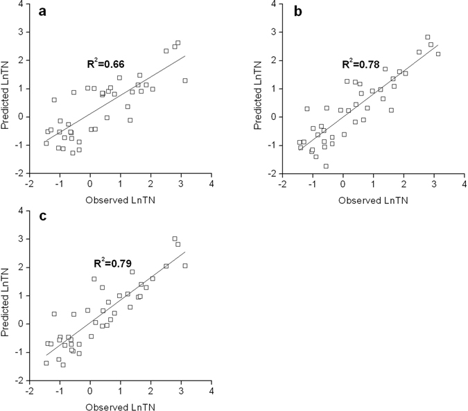
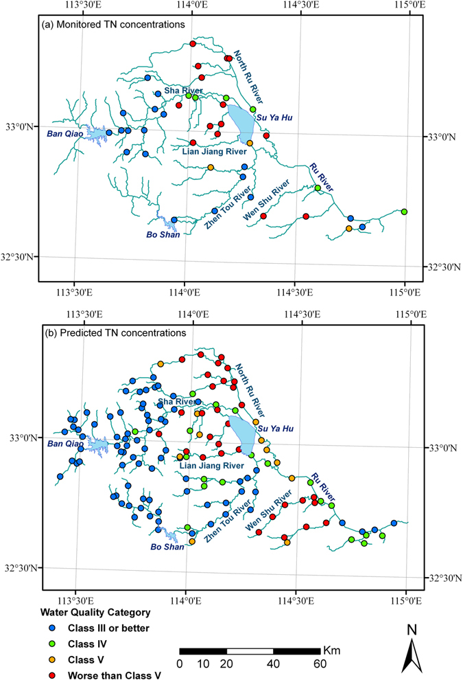
Fast economic development, burgeoning population growth, and rapid urbanization have led to complex pollution sources contributing to water quality deterioration simultaneously in many developing countries including China. This paper explored the use of spatial regression to evaluate the impacts of watershed characteristics on ambient total nitrogen (TN) concentration in a heavily polluted watershed and make predictions across the region. Regression results have confirmed the substantial impact on TN concentration by a variety of point and non-point pollution sources. In addition, spatial regression has yielded better performance than ordinary regression in predicting TN concentrations. Due to its best performance in cross-validation, the river distance based spatial regression model was used to predict TN concentrations across the watershed. The prediction results have revealed a distinct pattern in the spatial distribution of TN concentrations and identified three critical sub-regions in priority for reducing TN loads. Our study results have indicated that spatial regression could potentially serve as an effective tool to facilitate water pollution control in watersheds under diverse physical and socio-economical conditions.

摘要

快速的经济发展、人口的迅速增长和快速的城市化进程,导致许多发展中国家(包括中国)的水污染同时受到复杂的污染源的影响,水质不断恶化。本文探讨了利用空间回归来评估流域特征对污染严重的流域中环境总氮(TN)浓度的影响,并对整个区域进行预测。回归结果证实了各种点源和非点源污染对 TN 浓度的重大影响。此外,空间回归在预测 TN 浓度方面的表现优于普通回归。由于基于河流距离的空间回归模型在交叉验证中表现最佳,因此被用于预测整个流域的 TN 浓度。预测结果揭示了 TN 浓度的空间分布模式,并确定了三个需要优先减少 TN 负荷的关键子区域。我们的研究结果表明,空间回归可能是一种有效的工具,可在不同的自然和社会经济条件下促进流域的水污染控制。

https://cdn.ncbi.nlm.nih.gov/pmc/blobs/febf/5559613/4505537443a4/41598_2017_8254_Fig5_HTML.jpg
https://cdn.ncbi.nlm.nih.gov/pmc/blobs/febf/5559613/1b3fb3a6d5ea/41598_2017_8254_Fig1_HTML.jpg
https://cdn.ncbi.nlm.nih.gov/pmc/blobs/febf/5559613/1b746a83db3d/41598_2017_8254_Fig2_HTML.jpg
https://cdn.ncbi.nlm.nih.gov/pmc/blobs/febf/5559613/e9e62447f781/41598_2017_8254_Fig3_HTML.jpg
https://cdn.ncbi.nlm.nih.gov/pmc/blobs/febf/5559613/930ca67b08b9/41598_2017_8254_Fig4_HTML.jpg
https://cdn.ncbi.nlm.nih.gov/pmc/blobs/febf/5559613/4505537443a4/41598_2017_8254_Fig5_HTML.jpg

相似文献

1
Spatial Regression and Prediction of Water Quality in a Watershed with Complex Pollution Sources.具有复杂污染源流域水质的空间回归与预测。
Sci Rep. 2017 Aug 16;7(1):8318. doi: 10.1038/s41598-017-08254-w.
2
Stochastic sensitivity analysis of nitrogen pollution to climate change in a river basin with complex pollution sources.流域复杂污染源氮污染对气候变化的随机敏感性分析。
Environ Sci Pollut Res Int. 2017 Dec;24(34):26545-26561. doi: 10.1007/s11356-017-0257-y. Epub 2017 Sep 26.
3
[Nitrogen non-point source pollution identification based on ArcSWAT in Changle River].基于ArcSWAT的长乐溪氮素面源污染识别
Huan Jing Ke Xue. 2013 Apr;34(4):1284-90.
4
Spatial and temporal variations of water quality in Cao-E River of eastern China.中国东部曹娥江水质的时空变化
J Environ Sci (China). 2006;18(4):680-8.
5
Assessment of water quality and identification of polluted risky regions based on field observations & GIS in the Honghe River watershed, China.基于实地观测和地理信息系统(GIS)对中国红河分水岭水质进行评估及污染风险区域识别
PLoS One. 2015 Mar 13;10(3):e0119130. doi: 10.1371/journal.pone.0119130. eCollection 2015.
6
In-time source tracking of watershed loads of Taihu Lake Basin, China based on spatial relationship modeling.基于空间关系建模的太湖流域面源负荷及时溯源。
Environ Sci Pollut Res Int. 2018 Aug;25(22):22085-22094. doi: 10.1007/s11356-018-2304-8. Epub 2018 May 25.
7
GIS-based spatial regression and prediction of water quality in river networks: a case study in Iowa.基于 GIS 的河网水质空间回归与预测——以爱荷华州为例
J Environ Manage. 2010 Oct;91(10):1943-51. doi: 10.1016/j.jenvman.2010.04.011. Epub 2010 May 31.
8
Forecasting riverine total nitrogen loads using wavelet analysis and support vector regression combination model in an agricultural watershed.基于小波分析和支持向量回归组合模型的流域河流总氮负荷预测。
Environ Sci Pollut Res Int. 2018 Sep;25(26):26405-26422. doi: 10.1007/s11356-018-2698-3. Epub 2018 Jul 7.
9
Impacts of climate change on TN load and its control in a River Basin with complex pollution sources.气候变化对流域复杂污染源 TN 负荷及其控制的影响。
Sci Total Environ. 2018 Feb 15;615:1155-1163. doi: 10.1016/j.scitotenv.2017.09.288. Epub 2017 Oct 17.
10
[Influencing factors of non-point source pollution of watershed based on boosted regression tree algorithm.].基于提升回归树算法的流域非点源污染影响因素研究。
Ying Yong Sheng Tai Xue Bao. 2016 Mar;27(3):911-919. doi: 10.13287/j.1001-9332.201603.020.

引用本文的文献

1
Evolution characteristics and driving factors of potential non-point source pollution risks in a watershed affected by land use changes.土地利用变化影响下流域潜在面源污染风险的演变特征及驱动因素
Heliyon. 2024 Aug 30;10(17):e37247. doi: 10.1016/j.heliyon.2024.e37247. eCollection 2024 Sep 15.
2
Data Insights for Sustainable Cities: Associations between Google Street View-Derived Urban Greenspace and Google Air View-Derived Pollution Levels.数据洞察可持续城市:谷歌街景衍生城市绿地与谷歌航拍衍生污染水平之间的关联。
Environ Sci Technol. 2023 Dec 5;57(48):19637-19648. doi: 10.1021/acs.est.3c05000. Epub 2023 Nov 16.
3

本文引用的文献

1
The Relationship between Land Use and Vulnerability to Nitrogen and Phosphorus Pollution in an Urban Watershed.城市流域土地利用与氮磷污染脆弱性之间的关系
J Environ Qual. 2017 Jan;46(1):113-122. doi: 10.2134/jeq2016.06.0239.
2
Deep challenges for China's war on water pollution.中国水污染防治攻坚战面临的深层挑战。
Environ Pollut. 2016 Nov;218:1222-1233. doi: 10.1016/j.envpol.2016.08.078. Epub 2016 Sep 6.
3
Impacts of land use and population density on seasonal surface water quality using a modified geographically weighted regression.
Effect of different levels of EDTA on phytoextraction of heavy metal and growth of L.
不同水平的乙二胺四乙酸(EDTA)对重金属植物提取及[植物名称未给出]生长的影响
Front Microbiol. 2023 Aug 3;14:1228117. doi: 10.3389/fmicb.2023.1228117. eCollection 2023.
4
Rapid assessment of heavy metal pollution using ion-exchange resin sachets and micro-XRF core-scanning.利用离子交换树脂小袋和微 XRF 芯扫描快速评估重金属污染。
Sci Rep. 2019 Apr 29;9(1):6601. doi: 10.1038/s41598-019-43015-x.
5
Evaluating the applicability of MESS (matrix exponential spatial specification) model to assess water quality using GIS technique in agricultural mountain catchment (Western Carpathian).利用 GIS 技术评估 MESS(矩阵指数空间规范)模型在农业山区流域(西喀尔巴阡山脉)评估水质的适用性。
Environ Monit Assess. 2018 Dec 21;191(1):26. doi: 10.1007/s10661-018-7137-x.
利用改进的地理加权回归研究土地利用和人口密度对季节性地表水水质的影响。
Sci Total Environ. 2016 Dec 1;572:450-466. doi: 10.1016/j.scitotenv.2016.08.052. Epub 2016 Aug 18.
4
Influences of anthropogenic activities and topography on water quality in the highly regulated Huai River basin, China.人为活动和地形对中国高度管控的淮河流域水质的影响。
Environ Sci Pollut Res Int. 2016 Nov;23(21):21460-21474. doi: 10.1007/s11356-016-7368-8. Epub 2016 Aug 10.
5
Multi-scale analysis of relationship between landscape pattern and urban river water quality in different seasons.不同季节景观格局与城市河流水质关系的多尺度分析
Sci Rep. 2016 May 5;6:25250. doi: 10.1038/srep25250.
6
Understanding the relationship of land uses and water quality in Twenty First Century: A review.理解21世纪土地利用与水质的关系:综述
J Environ Manage. 2016 May 15;173:41-8. doi: 10.1016/j.jenvman.2016.02.029. Epub 2016 Mar 8.
7
Spatiotemporal patterns and source attribution of nitrogen load in a river basin with complex pollution sources.流域氮素污染时空格局及来源解析。
Water Res. 2016 May 1;94:187-199. doi: 10.1016/j.watres.2016.02.040. Epub 2016 Feb 18.
8
Influences of the land use pattern on water quality in low-order streams of the Dongjiang River basin, China: A multi-scale analysis.土地利用模式对中国东江流域低阶河流水质的影响:多尺度分析。
Sci Total Environ. 2016 May 1;551-552:205-16. doi: 10.1016/j.scitotenv.2016.01.162. Epub 2016 Feb 12.
9
Impacts of soil and water pollution on food safety and health risks in China.土壤和水污染对中国食品安全和健康风险的影响。
Environ Int. 2015 Apr;77:5-15. doi: 10.1016/j.envint.2014.12.010. Epub 2015 Jan 17.
10
Modeling relationships between catchment attributes and river water quality in southern catchments of the Caspian Sea.里海南部流域集水区属性与河流水质之间的关系建模
Environ Sci Pollut Res Int. 2015 Apr;22(7):4985-5002. doi: 10.1007/s11356-014-3727-5. Epub 2014 Nov 15.