• 文献检索
  • 文档翻译
  • 深度研究
  • 学术资讯
  • Suppr Zotero 插件Zotero 插件
  • 邀请有礼
  • 套餐&价格
  • 历史记录
应用&插件
Suppr Zotero 插件Zotero 插件浏览器插件Mac 客户端Windows 客户端微信小程序
定价
高级版会员购买积分包购买API积分包
服务
文献检索文档翻译深度研究API 文档MCP 服务
关于我们
关于 Suppr公司介绍联系我们用户协议隐私条款
关注我们

Suppr 超能文献

核心技术专利:CN118964589B侵权必究
粤ICP备2023148730 号-1Suppr @ 2026

文献检索

告别复杂PubMed语法,用中文像聊天一样搜索,搜遍4000万医学文献。AI智能推荐,让科研检索更轻松。

立即免费搜索

文件翻译

保留排版,准确专业,支持PDF/Word/PPT等文件格式,支持 12+语言互译。

免费翻译文档

深度研究

AI帮你快速写综述,25分钟生成高质量综述,智能提取关键信息,辅助科研写作。

立即免费体验

使用遗传算法对TLS-TLS和TLS-MLS点云进行自动配准

Automatic Registration of TLS-TLS and TLS-MLS Point Clouds Using a Genetic Algorithm.

作者信息

Yan Li, Tan Junxiang, Liu Hua, Xie Hong, Chen Changjun

机构信息

School of Geodesy and Geomatics, Wuhan University, Luoyu Road 129, Wuhan 430079, China.

出版信息

Sensors (Basel). 2017 Aug 29;17(9):1979. doi: 10.3390/s17091979.

DOI:10.3390/s17091979
PMID:28850100
原文链接:https://pmc.ncbi.nlm.nih.gov/articles/PMC5621137/
Abstract

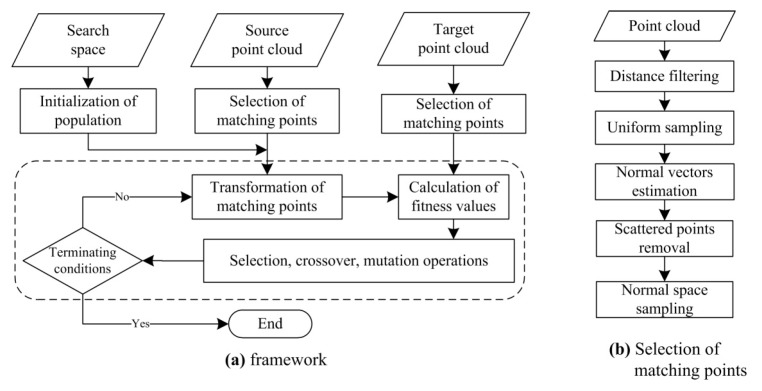
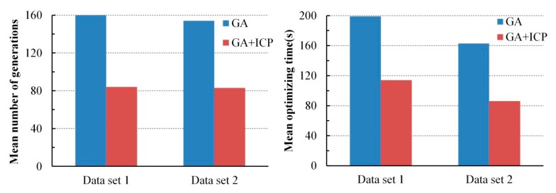
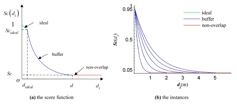
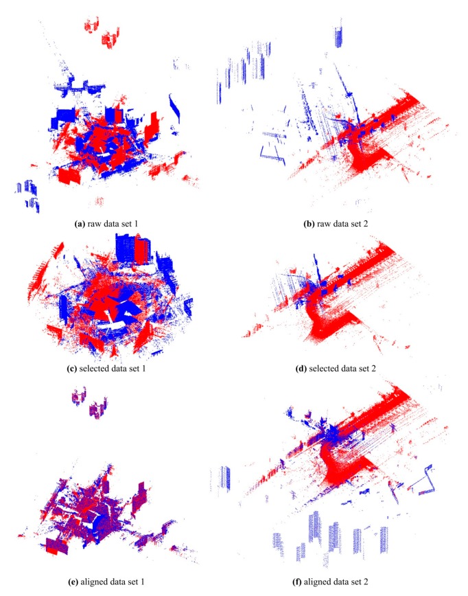
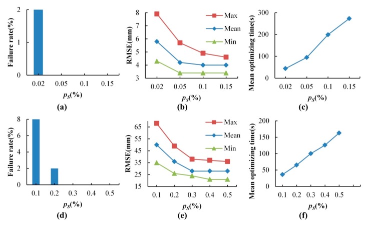
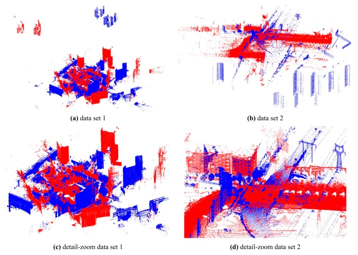
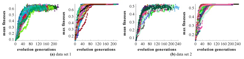
Registration of point clouds is a fundamental issue in Light Detection and Ranging (LiDAR) remote sensing because point clouds scanned from multiple scan stations or by different platforms need to be transformed to a uniform coordinate reference frame. This paper proposes an efficient registration method based on genetic algorithm (GA) for automatic alignment of two terrestrial LiDAR scanning (TLS) point clouds (TLS-TLS point clouds) and alignment between TLS and mobile LiDAR scanning (MLS) point clouds (TLS-MLS point clouds). The scanning station position acquired by the TLS built-in GPS and the quasi-horizontal orientation of the LiDAR sensor in data acquisition are used as constraints to narrow the search space in GA. A new fitness function to evaluate the solutions for GA, named as Normalized Sum of Matching Scores, is proposed for accurate registration. Our method is divided into five steps: selection of matching points, initialization of population, transformation of matching points, calculation of fitness values, and genetic operation. The method is verified using a TLS-TLS data set and a TLS-MLS data set. The experimental results indicate that the RMSE of registration of TLS-TLS point clouds is 35 mm, and that of TLS-MLS point clouds is 24 cm. The registration integrating the existing well-known ICP with GA is further proposed to accelerate the optimization and its optimizing time decreases by about 50%.

摘要

点云配准是激光雷达(LiDAR)遥感中的一个基本问题,因为从多个扫描站或不同平台扫描得到的点云需要转换到统一的坐标参考系中。本文提出了一种基于遗传算法(GA)的高效配准方法,用于自动对齐两个地面激光雷达扫描(TLS)点云(TLS-TLS点云)以及TLS与移动激光雷达扫描(MLS)点云之间的对齐(TLS-MLS点云)。利用TLS内置GPS获取的扫描站位置以及数据采集中激光雷达传感器的准水平方向作为约束条件,以缩小遗传算法中的搜索空间。提出了一种新的适应度函数来评估遗传算法的解,称为归一化匹配分数之和,用于精确配准。我们的方法分为五个步骤:匹配点的选择、种群初始化、匹配点的变换、适应度值的计算以及遗传操作。使用一个TLS-TLS数据集和一个TLS-MLS数据集对该方法进行了验证。实验结果表明,TLS-TLS点云配准的均方根误差(RMSE)为35毫米,TLS-MLS点云配准的RMSE为24厘米。进一步提出了将现有的著名迭代最近点(ICP)算法与遗传算法相结合的配准方法,以加速优化过程,其优化时间减少了约50%。

https://cdn.ncbi.nlm.nih.gov/pmc/blobs/c01d/5621137/a6767ae4513d/sensors-17-01979-g011.jpg
https://cdn.ncbi.nlm.nih.gov/pmc/blobs/c01d/5621137/278cd28f2d76/sensors-17-01979-g001.jpg
https://cdn.ncbi.nlm.nih.gov/pmc/blobs/c01d/5621137/c3b72c8dfd1f/sensors-17-01979-g002.jpg
https://cdn.ncbi.nlm.nih.gov/pmc/blobs/c01d/5621137/ff78b96922aa/sensors-17-01979-g003.jpg
https://cdn.ncbi.nlm.nih.gov/pmc/blobs/c01d/5621137/13762b12fb45/sensors-17-01979-g004.jpg
https://cdn.ncbi.nlm.nih.gov/pmc/blobs/c01d/5621137/4e5f668d1f2d/sensors-17-01979-g005.jpg
https://cdn.ncbi.nlm.nih.gov/pmc/blobs/c01d/5621137/45ab831eb89a/sensors-17-01979-g006.jpg
https://cdn.ncbi.nlm.nih.gov/pmc/blobs/c01d/5621137/766f22e027f0/sensors-17-01979-g007.jpg
https://cdn.ncbi.nlm.nih.gov/pmc/blobs/c01d/5621137/3744c44b9880/sensors-17-01979-g008.jpg
https://cdn.ncbi.nlm.nih.gov/pmc/blobs/c01d/5621137/b55d7b95dfbe/sensors-17-01979-g009.jpg
https://cdn.ncbi.nlm.nih.gov/pmc/blobs/c01d/5621137/d873d898cd9b/sensors-17-01979-g010.jpg
https://cdn.ncbi.nlm.nih.gov/pmc/blobs/c01d/5621137/a6767ae4513d/sensors-17-01979-g011.jpg

相似文献

1
Automatic Registration of TLS-TLS and TLS-MLS Point Clouds Using a Genetic Algorithm.使用遗传算法对TLS-TLS和TLS-MLS点云进行自动配准
Sensors (Basel). 2017 Aug 29;17(9):1979. doi: 10.3390/s17091979.
2
Scan Line Based Road Marking Extraction from Mobile LiDAR Point Clouds.基于扫描线的移动激光雷达点云道路标线提取
Sensors (Basel). 2016 Jun 17;16(6):903. doi: 10.3390/s16060903.
3
Coarse Alignment Methodology of Point Cloud Based on Camera Position/Orientation Estimation Model.基于相机位置/方向估计模型的点云粗对齐方法
J Imaging. 2023 Dec 14;9(12):279. doi: 10.3390/jimaging9120279.
4
Registration of optical imagery and LiDAR data using an inherent geometrical constraint.利用固有几何约束对光学图像和激光雷达数据进行配准。
Opt Express. 2015 Mar 23;23(6):7694-702. doi: 10.1364/OE.23.007694.
5
A Rapid Terrestrial Laser Scanning Method for Coastal Erosion Studies: A Case Study at Freeport, Texas, USA.一种用于海岸侵蚀研究的快速地面激光扫描方法:以美国得克萨斯州弗里波特为例
Sensors (Basel). 2019 Jul 24;19(15):3252. doi: 10.3390/s19153252.
6
Automatic Registration of Terrestrial Laser Scanning Point Clouds using Panoramic Reflectance Images.基于全景反射图像的地面激光扫描点云自动配准
Sensors (Basel). 2009;9(4):2621-46. doi: 10.3390/s90402621. Epub 2009 Apr 15.
7
Automatic extraction and measurement of individual trees from mobile laser scanning point clouds of forests.从森林的移动激光扫描点云中自动提取和测量单棵树。
Ann Bot. 2021 Oct 27;128(6):787-804. doi: 10.1093/aob/mcab087.
8
Line-Based Registration of Panoramic Images and LiDAR Point Clouds for Mobile Mapping.用于移动测绘的全景图像与激光雷达点云的基于线的配准
Sensors (Basel). 2016 Dec 31;17(1):70. doi: 10.3390/s17010070.
9
An Iterative Closest Points Algorithm for Registration of 3D Laser Scanner Point Clouds with Geometric Features.一种用于具有几何特征的三维激光扫描仪点云配准的迭代最近点算法。
Sensors (Basel). 2017 Aug 11;17(8):1862. doi: 10.3390/s17081862.
10
Feature Analysis of Scanning Point Cloud of Structure and Research on Hole Repair Technology Considering Space-Ground Multi-Source 3D Data Acquisition.结构扫描点云特征分析及考虑天地多源三维数据采集的孔修复技术研究。
Sensors (Basel). 2022 Dec 8;22(24):9627. doi: 10.3390/s22249627.

引用本文的文献

1
A Cross-Source Point Cloud Registration Algorithm Based on Trigonometric Mutation Chaotic Harris Hawk Optimisation for Rockfill Dam Construction.基于三角变异混沌哈里斯鹰优化的土石坝施工跨源点云配准算法。
Sensors (Basel). 2023 May 21;23(10):4942. doi: 10.3390/s23104942.
2
Study on TLS Point Cloud Registration Algorithm for Large-Scale Outdoor Weak Geometric Features.大规模室外弱几何特征 TLS 点云配准算法研究。
Sensors (Basel). 2022 Jul 6;22(14):5072. doi: 10.3390/s22145072.

本文引用的文献

1
Scan Line Based Road Marking Extraction from Mobile LiDAR Point Clouds.基于扫描线的移动激光雷达点云道路标线提取
Sensors (Basel). 2016 Jun 17;16(6):903. doi: 10.3390/s16060903.
2
Development of Mobile Mapping System for 3D Road Asset Inventory.用于三维道路资产清查的移动测绘系统的开发。
Sensors (Basel). 2016 Mar 12;16(3):367. doi: 10.3390/s16030367.
3
Automatic Registration of Terrestrial Laser Scanning Point Clouds using Panoramic Reflectance Images.基于全景反射图像的地面激光扫描点云自动配准
Sensors (Basel). 2009;9(4):2621-46. doi: 10.3390/s90402621. Epub 2009 Apr 15.
4
Precision range image registration using a robust surface interpenetration measure and enhanced genetic algorithms.使用稳健的表面互穿度量和改进的遗传算法进行精确距离图像配准。
IEEE Trans Pattern Anal Mach Intell. 2005 May;27(5):762-76. doi: 10.1109/TPAMI.2005.108.