Walker David, Parkin Geoff, Schmitter Petra, Gowing John, Tilahun Seifu A, Haile Alemseged T, Yimam Abdu Y
School of Engineering, Newcastle University, Newcastle upon Tyne, UK.
International Water Management Institute (IWMI), Addis Ababa, Ethiopia.
Ground Water. 2019 Mar;57(2):245-258. doi: 10.1111/gwat.12801. Epub 2018 Jul 19.
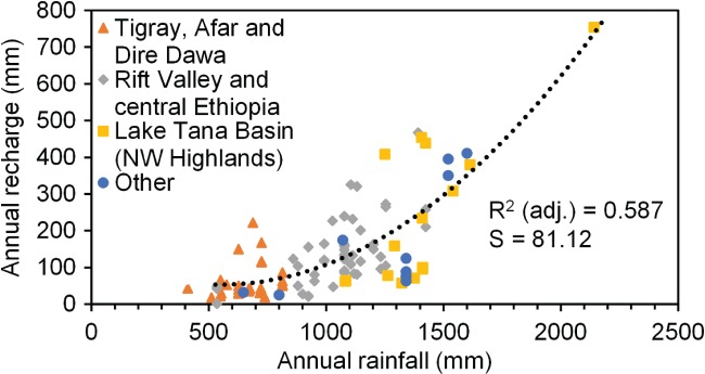
Although most recharge estimation studies apply multiple methods to identify the possible range in recharge values, many do not distinguish clearly enough between inherent uncertainty of the methods and other factors affecting the results. We investigated the additional value that can be gained from multi-method recharge studies through insights into hydrogeological understanding, in addition to characterizing uncertainty. Nine separate groundwater recharge estimation methods, with a total of 17 variations, were applied at a shallow aquifer in northwest Ethiopia in the context of the potential for shallow groundwater resource development. These gave a wide range of recharge values from 45 to 814 mm/a. Critical assessment indicated that the results depended on what the recharge represents (actual, potential, minimum recharge or change in aquifer storage), and spatial and temporal scales, as well as uncertainties from application of each method. Important insights into the hydrogeological system were gained from this detailed analysis, which also confirmed that the range of values for actual recharge was reduced to around 280-430 mm/a. This study demonstrates that even when assumptions behind methods are violated, as they often are to some degree especially when data are limited, valuable insights into the hydrogeological system can be gained from application of multiple methods.
尽管大多数补给量估算研究采用多种方法来确定补给量值的可能范围,但许多研究并未充分区分方法的固有不确定性与影响结果的其他因素。除了描述不确定性之外,我们还通过深入了解水文地质情况,研究了多方法补给量研究能带来的额外价值。在埃塞俄比亚西北部的一个浅层含水层中,针对浅层地下水资源开发潜力的背景,应用了九种单独的地下水补给量估算方法,共17种变体。这些方法得出的补给量值范围很广,从45毫米/年到814毫米/年不等。批判性评估表明,结果取决于补给量所代表的含义(实际的、潜在的、最小补给量或含水层储存量的变化)、空间和时间尺度,以及每种方法应用中的不确定性。通过这一详细分析,我们对水文地质系统有了重要的认识,这也证实了实际补给量的值范围缩小到了约280 - 430毫米/年。这项研究表明,即使方法背后的假设被违反,就像它们在某种程度上经常出现的那样,尤其是在数据有限时,应用多种方法仍能获得有关水文地质系统的宝贵见解。