• 文献检索
  • 文档翻译
  • 深度研究
  • 学术资讯
  • Suppr Zotero 插件Zotero 插件
  • 邀请有礼
  • 套餐&价格
  • 历史记录
应用&插件
Suppr Zotero 插件Zotero 插件浏览器插件Mac 客户端Windows 客户端微信小程序
定价
高级版会员购买积分包购买API积分包
服务
文献检索文档翻译深度研究API 文档MCP 服务
关于我们
关于 Suppr公司介绍联系我们用户协议隐私条款
关注我们

Suppr 超能文献

核心技术专利:CN118964589B侵权必究
粤ICP备2023148730 号-1Suppr @ 2026

文献检索

告别复杂PubMed语法,用中文像聊天一样搜索,搜遍4000万医学文献。AI智能推荐,让科研检索更轻松。

立即免费搜索

文件翻译

保留排版,准确专业,支持PDF/Word/PPT等文件格式,支持 12+语言互译。

免费翻译文档

深度研究

AI帮你快速写综述,25分钟生成高质量综述,智能提取关键信息,辅助科研写作。

立即免费体验

Surface Correlation-Based Fingerprinting Method Using LTE Signal for Localization in Urban Canyon.

作者信息

Lee Jung Ho, Shin Beomju, Shin Donghyun, Park Jinwoo, Ryu Yong Sang, Woo Deok Ha, Lee Taikjin

机构信息

Sensor System Research Center, Korea Institute of Science and Technology, 5, Hwarang-ro 14-gil, Seongbuk-gu, Seoul 02972, Korea.

Department of Electrical and Computer Engineering, Korea University, Anam-dong, Seungbuk-gu, Seoul 136-713, Korea.

出版信息

Sensors (Basel). 2019 Jul 29;19(15):3325. doi: 10.3390/s19153325.

DOI:10.3390/s19153325
PMID:31362386
原文链接:https://pmc.ncbi.nlm.nih.gov/articles/PMC6696050/
Abstract

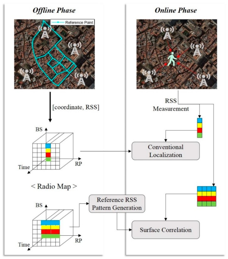
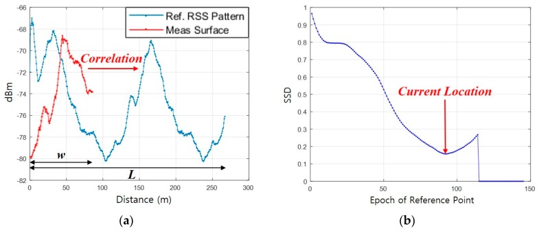
The Global Satellite Navigation System (GNSS) used in various location-based services is accurate and stable in outdoor environments. However, it cannot be utilized in an indoor environment because of low signal availability and degradation of accuracy due to the multipath distortion of satellite signals in urban areas. On the contrary, LTE signals are available almost everywhere in urban areas and are quite stable without much variation throughout the year. This is because of the fixed location of base stations and the well-maintained policy of mobile communication service providers. Its varied stability and reliability make LTE signals a more viable method for localization. However, there are some complexities in utilizing LTE signals including signal interference distortion phenomena during propagation multipath fading, and various types of noise. In this paper, we propose a surface correlation-based fingerprinting method to utilize LTE signals for localization in urban areas. The surface correlation converts timely measured signal strength into spatial pattern using the walking distance from a Pedestrian Dead-Reckoning (PDR). The surface correlation is carried out by comparing the spatial signal strength pattern of a pedestrian`s movement trajectory with a fingerprinting database to estimate the location. A reference trajectory of the moving pedestrian is chosen to have a greater correlation among the multiple trajectory candidates generated from a link-based fingerprinting database. By comparing spatial signal strength patterns, the proposed method can improve robustness in localization overcoming the accuracy degradation problem due to RF multipath and noise that are dominant in the conventional RSS measurement-based LTE localization scheme. The test results in urban areas demonstrate that the proposed surface correlation-based fingerprinting method has improved performance compared to the other conventional methods, thus proving to be a useful complementary method to the GNSS in urban areas.

摘要
https://cdn.ncbi.nlm.nih.gov/pmc/blobs/d190/6696050/c12585644396/sensors-19-03325-g008a.jpg
https://cdn.ncbi.nlm.nih.gov/pmc/blobs/d190/6696050/edc4d87de5b2/sensors-19-03325-g001.jpg
https://cdn.ncbi.nlm.nih.gov/pmc/blobs/d190/6696050/02e9dd54bc12/sensors-19-03325-g002.jpg
https://cdn.ncbi.nlm.nih.gov/pmc/blobs/d190/6696050/1709610e1a24/sensors-19-03325-g003.jpg
https://cdn.ncbi.nlm.nih.gov/pmc/blobs/d190/6696050/f3156e98522b/sensors-19-03325-g005.jpg
https://cdn.ncbi.nlm.nih.gov/pmc/blobs/d190/6696050/4e9dc8267204/sensors-19-03325-g007.jpg
https://cdn.ncbi.nlm.nih.gov/pmc/blobs/d190/6696050/c12585644396/sensors-19-03325-g008a.jpg

相似文献

1
Surface Correlation-Based Fingerprinting Method Using LTE Signal for Localization in Urban Canyon.
Sensors (Basel). 2019 Jul 29;19(15):3325. doi: 10.3390/s19153325.
2
Pedestrian Positioning Using a Double-Stacked Particle Filter in Indoor Wireless Networks.利用双层粒子滤波器进行室内无线网络中的行人定位。
Sensors (Basel). 2019 Sep 10;19(18):3907. doi: 10.3390/s19183907.
3
Feasibility Analysis of LTE-Based UAS Navigation in Deep Urban Areas and DSRC Augmentation.基于 LTE 的无人机系统在深度城市区域和专用短程通信技术增强中的可行性分析。
Sensors (Basel). 2019 Sep 27;19(19):4192. doi: 10.3390/s19194192.
4
Multi-Phase Fusion for Pedestrian Localization Using Mass-Market GNSS and MEMS Sensors.基于大众市场 GNSS 和 MEMS 传感器的行人定位的多阶段融合。
Sensors (Basel). 2023 Mar 30;23(7):3624. doi: 10.3390/s23073624.
5
A Low-Cost and Efficient Indoor Fusion Localization Method.一种低成本高效的室内融合定位方法。
Sensors (Basel). 2022 Jul 23;22(15):5505. doi: 10.3390/s22155505.
6
Use of high sensitivity GNSS receiver Doppler measurements for indoor pedestrian dead reckoning.利用高灵敏度 GNSS 接收机多普勒测量进行室内行人航位推算。
Sensors (Basel). 2013 Mar 28;13(4):4303-26. doi: 10.3390/s130404303.
7
GNSS Trajectory Anomaly Detection Using Similarity Comparison Methods for Pedestrian Navigation.利用相似性比较方法进行行人导航的 GNSS 轨迹异常检测。
Sensors (Basel). 2018 Sep 19;18(9):3165. doi: 10.3390/s18093165.
8
Coordinate-Based Clustering Method for Indoor Fingerprinting Localization in Dense Cluttered Environments.密集杂乱环境下室内指纹定位的基于坐标的聚类方法
Sensors (Basel). 2016 Dec 2;16(12):2055. doi: 10.3390/s16122055.
9
A Robust Crowdsourcing-Based Indoor Localization System.一种基于众包的稳健室内定位系统。
Sensors (Basel). 2017 Apr 14;17(4):864. doi: 10.3390/s17040864.
10
A Context-Recognition-Aided PDR Localization Method Based on the Hidden Markov Model.一种基于隐马尔可夫模型的上下文识别辅助行人航位推算定位方法。
Sensors (Basel). 2016 Nov 30;16(12):2030. doi: 10.3390/s16122030.

引用本文的文献

1
Simultaneous LTE Signal Propagation Modelling and Base Station Positioning Based on Multiple Virtual Locations.基于多个虚拟位置的长期演进(LTE)信号同步传播建模与基站定位
Sensors (Basel). 2022 Aug 8;22(15):5917. doi: 10.3390/s22155917.
2
Underground Parking Lot Navigation System Using Long-Term Evolution Signal.基于长期演进信号的地下停车场导航系统
Sensors (Basel). 2021 Mar 2;21(5):1725. doi: 10.3390/s21051725.

本文引用的文献

1
Analysis of Sources of Large Positioning Errors in Deterministic Fingerprinting.确定性指纹识别中大型定位误差来源分析
Sensors (Basel). 2017 Nov 27;17(12):2736. doi: 10.3390/s17122736.