American University of Beirut, Beirut, Lebanon.
Sci Data. 2019 Aug 12;6(1):145. doi: 10.1038/s41597-019-0155-x.
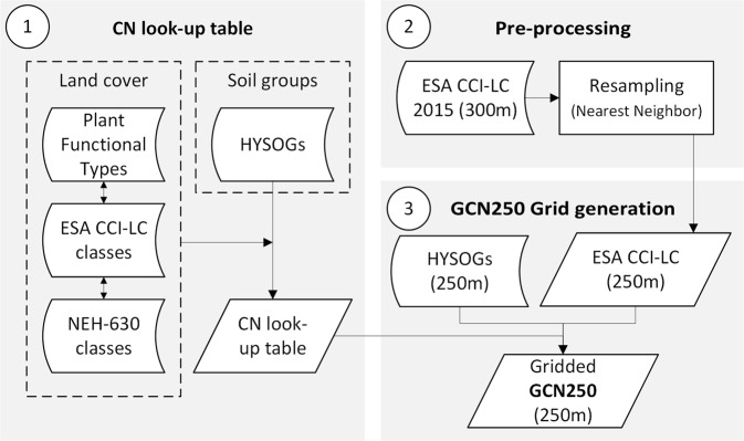
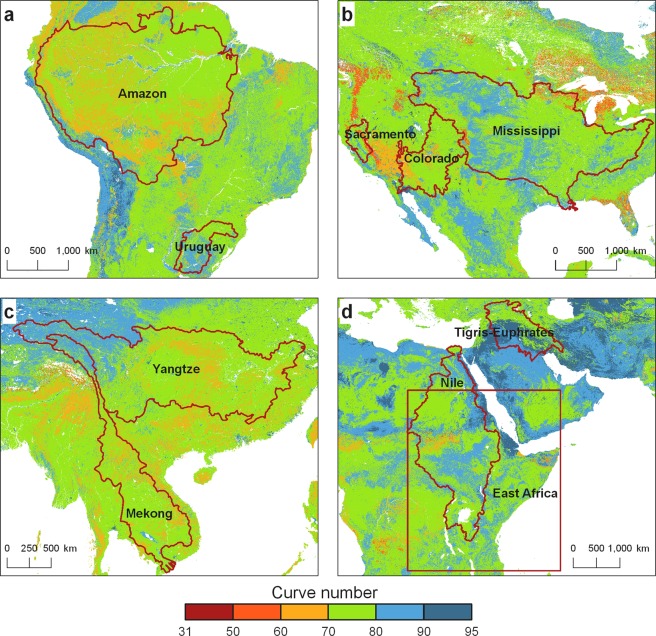
The USDA curve-number (CN) method is fundamental for rainfall-runoff modeling. A global CN database is not currently available for geospatial hydrologic analysis at a resolution higher than 0.1°. We developed a globally consistent, gridded dataset defining CNs at the 250 m spatial resolution from new global land cover (300 m) and soils data (250 m). The resulting data product - GCN250 - represents runoff for a combination of the European space agency global land cover dataset for 2015 (ESA CCI-LC) resampled to 250 m and geo-registered with the hydrologic soil group global data product (HYSOGs250m) released in 2018. Our analysis indicated that medium to high runoff potential currently dominates the globe, with curve numbers ranging between 75 and 85. Global curve numbers were 62, 78, and 90 for dry, average, and wet antecedent runoff conditions, respectively. Australia has the highest runoff potential, while Europe has the lowest. Runoff ratios compare well with GLDAS. The potential application of this data includes hydrologic design, land management applications, flood risk assessment, and groundwater recharge modeling.
美国农业部雨型曲线数(CN)方法是降雨径流建模的基础。目前,全球范围内没有可供地理空间水文分析使用的、空间分辨率高于 0.1°的 CN 数据库。我们开发了一个全球一致的、网格化数据集,该数据集以 250 米的空间分辨率定义了 CN,数据来源于新的全球土地覆盖(300 米)和土壤数据(250 米)。由此产生的数据产品-GCN250-代表了 2015 年欧洲航天局全球土地覆盖数据集(ESA CCI-LC)的组合径流,该数据集经过重采样至 250 米,并与 2018 年发布的水文土壤组全球数据产品(HYSOGs250m)进行了地理配准。我们的分析表明,全球目前以中高径流量潜力为主,雨型曲线数在 75 到 85 之间。干、平均和湿前期径流量条件下的全球雨型曲线数分别为 62、78 和 90。澳大利亚具有最高的径流量潜力,而欧洲则最低。径流比与 GLDAS 比较吻合。该数据集的潜在应用包括水文设计、土地管理应用、洪水风险评估和地下水补给建模。