• 文献检索
  • 文档翻译
  • 深度研究
  • 学术资讯
  • Suppr Zotero 插件Zotero 插件
  • 邀请有礼
  • 套餐&价格
  • 历史记录
应用&插件
Suppr Zotero 插件Zotero 插件浏览器插件Mac 客户端Windows 客户端微信小程序
定价
高级版会员购买积分包购买API积分包
服务
文献检索文档翻译深度研究API 文档MCP 服务
关于我们
关于 Suppr公司介绍联系我们用户协议隐私条款
关注我们

Suppr 超能文献

核心技术专利:CN118964589B侵权必究
粤ICP备2023148730 号-1Suppr @ 2026

文献检索

告别复杂PubMed语法,用中文像聊天一样搜索,搜遍4000万医学文献。AI智能推荐,让科研检索更轻松。

立即免费搜索

文件翻译

保留排版,准确专业,支持PDF/Word/PPT等文件格式,支持 12+语言互译。

免费翻译文档

深度研究

AI帮你快速写综述,25分钟生成高质量综述,智能提取关键信息,辅助科研写作。

立即免费体验

无人机群在建筑物紧急情况下的三维轨迹规划方法。

3D Trajectory Planning Method for UAVs Swarm in Building Emergencies.

机构信息

Intelligent Systems Lab (LSI), Universidad Carlos III de Madrid, Avnd. Universidad 30, 28911 Leganés, Madrid, Spain.

出版信息

Sensors (Basel). 2020 Jan 23;20(3):642. doi: 10.3390/s20030642.

DOI:10.3390/s20030642
PMID:31979281
原文链接:https://pmc.ncbi.nlm.nih.gov/articles/PMC7038361/
Abstract

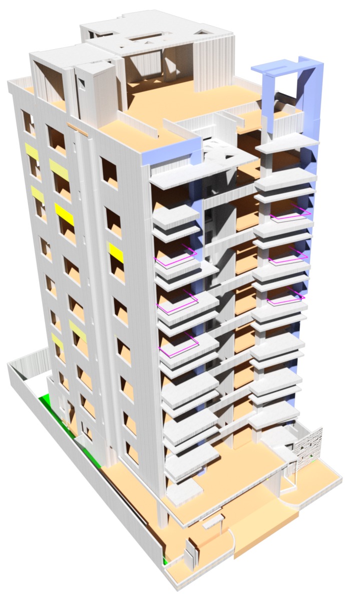
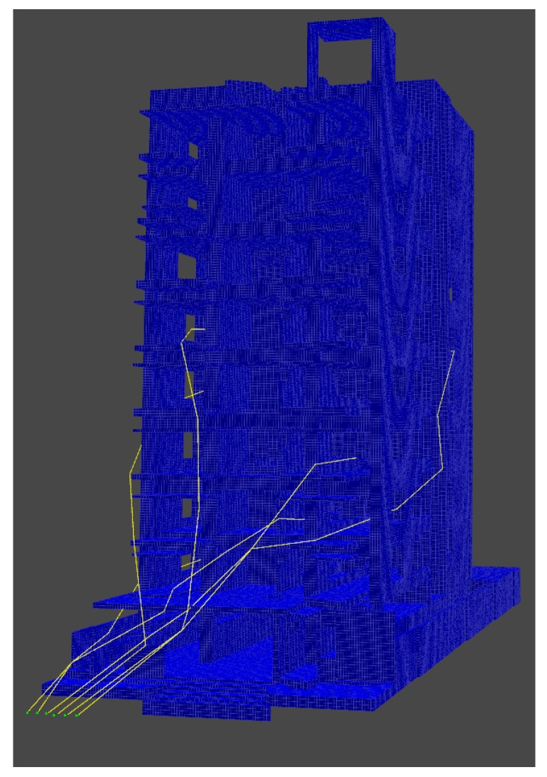
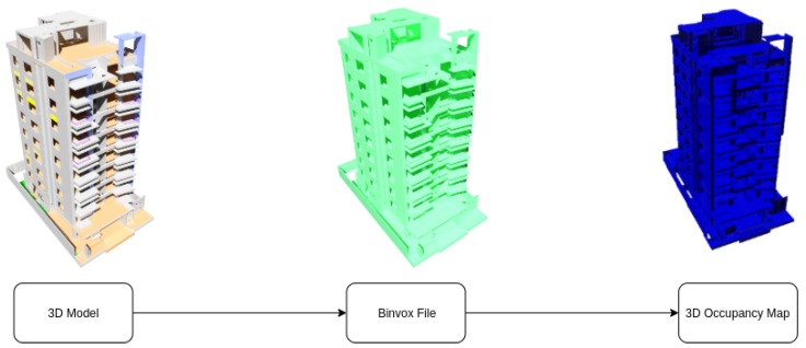
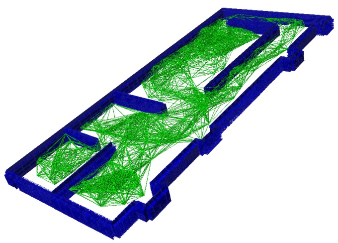
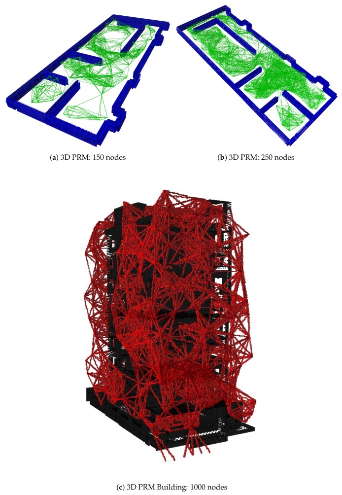
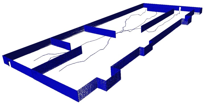
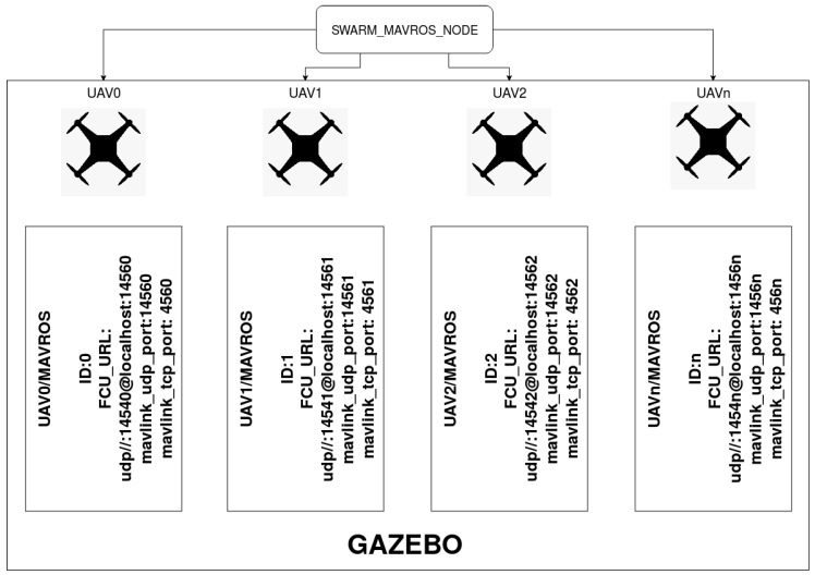
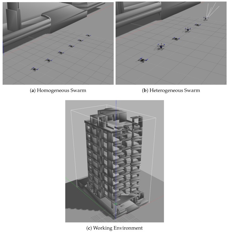
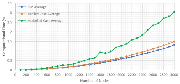
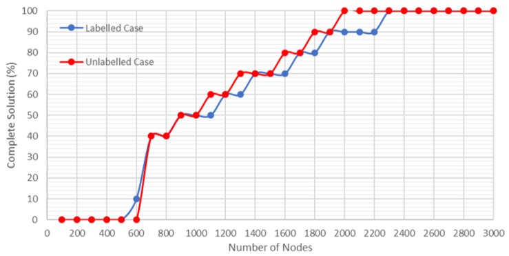
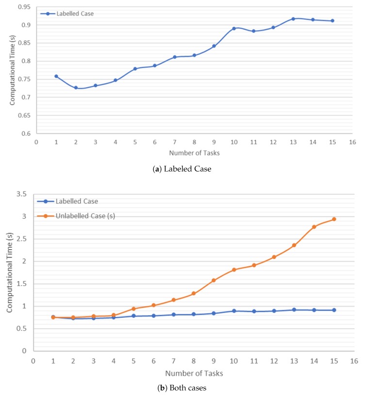
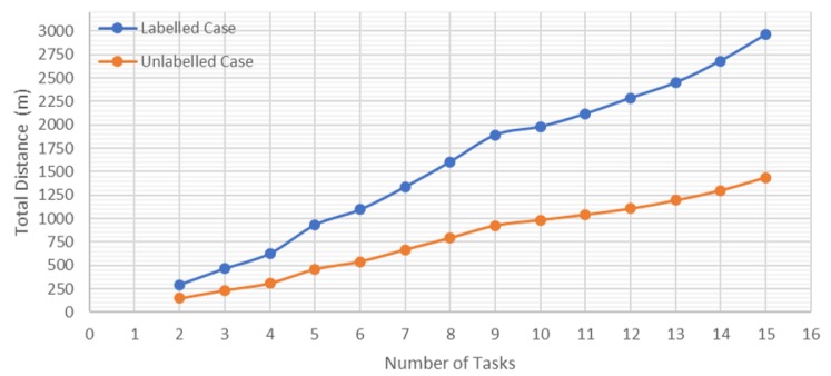
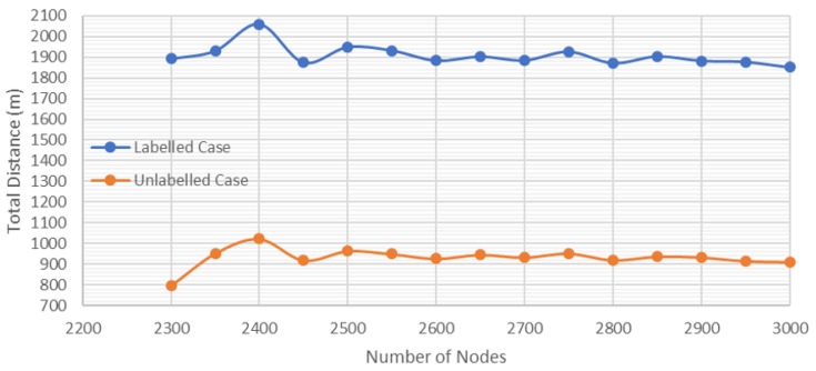
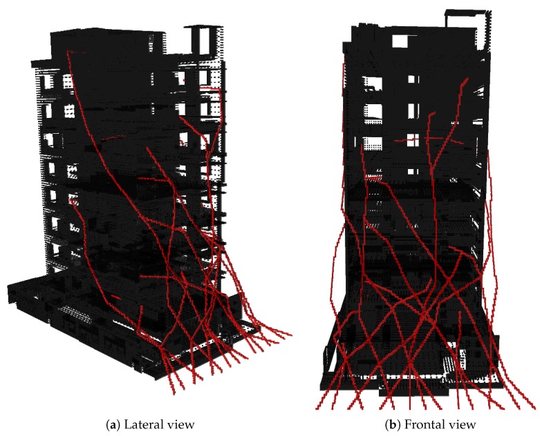
The development in Multi-Robot Systems (MRS) has become one of the most exploited fields of research in robotics in recent years. This is due to the robustness and versatility they present to effectively undertake a set of tasks autonomously. One of the essential elements for several vehicles, in this case, Unmanned Aerial Vehicles (UAVs), to perform tasks autonomously and cooperatively is trajectory planning, which is necessary to guarantee the safe and collision-free movement of the different vehicles. This document includes the planning of multiple trajectories for a swarm of UAVs based on 3D Probabilistic Roadmaps (PRM). This swarm is capable of reaching different locations of interest in different cases (labeled and unlabeled), supporting of an Emergency Response Team (ERT) in emergencies in urban environments. In addition, an architecture based on Robot Operating System (ROS) is presented to allow the simulation and integration of the methods developed in a UAV swarm. This architecture allows the communications with the MavLink protocol and control via the Pixhawk autopilot, for a quick and easy implementation in real UAVs. The proposed method was validated by experiments simulating building emergences. Finally, the obtained results show that methods based on probability roadmaps create effective solutions in terms of calculation time in the case of scalable systems in different situations along with their integration into a versatile framework such as ROS.

摘要

多机器人系统(MRS)的发展近年来已成为机器人学中最具研究价值的领域之一。这是由于它们具有强大的鲁棒性和多功能性,能够自主有效地完成一组任务。对于多辆车辆(在这种情况下是无人驾驶飞行器 (UAV))来说,自主和协作执行任务的一个基本要素是轨迹规划,这是确保不同车辆安全无碰撞移动的必要条件。

本文包括基于三维概率路线图 (PRM) 的 UAV 群的多条轨迹规划。该群能够在不同情况下(标记和未标记)到达不同感兴趣的位置,为城市环境中的应急响应团队 (ERT) 提供支持。此外,还提出了一种基于机器人操作系统 (ROS) 的架构,以允许在 UAV 群中模拟和集成开发的方法。该架构允许与 MavLink 协议进行通信,并通过 Pixhawk 自动驾驶仪进行控制,以便在真实的 UAV 中快速轻松地实现。

所提出的方法通过模拟建筑物紧急情况的实验进行了验证。最后,所得结果表明,基于概率路线图的方法在可扩展系统的情况下,在不同情况下的计算时间方面会创建有效的解决方案,并且可以将其集成到 ROS 等通用框架中。

https://cdn.ncbi.nlm.nih.gov/pmc/blobs/baf1/7038361/9b757183b987/sensors-20-00642-g015.jpg
https://cdn.ncbi.nlm.nih.gov/pmc/blobs/baf1/7038361/3af98c93f446/sensors-20-00642-g001.jpg
https://cdn.ncbi.nlm.nih.gov/pmc/blobs/baf1/7038361/924f97614bfa/sensors-20-00642-g002.jpg
https://cdn.ncbi.nlm.nih.gov/pmc/blobs/baf1/7038361/2d269920726f/sensors-20-00642-g003.jpg
https://cdn.ncbi.nlm.nih.gov/pmc/blobs/baf1/7038361/9a390038d7a8/sensors-20-00642-g004.jpg
https://cdn.ncbi.nlm.nih.gov/pmc/blobs/baf1/7038361/00842b4dd1b1/sensors-20-00642-g005.jpg
https://cdn.ncbi.nlm.nih.gov/pmc/blobs/baf1/7038361/c18870a52d01/sensors-20-00642-g006.jpg
https://cdn.ncbi.nlm.nih.gov/pmc/blobs/baf1/7038361/0779c036e08a/sensors-20-00642-g007.jpg
https://cdn.ncbi.nlm.nih.gov/pmc/blobs/baf1/7038361/aaf94cff784e/sensors-20-00642-g008.jpg
https://cdn.ncbi.nlm.nih.gov/pmc/blobs/baf1/7038361/0b0d51359787/sensors-20-00642-g009.jpg
https://cdn.ncbi.nlm.nih.gov/pmc/blobs/baf1/7038361/a23269f6b667/sensors-20-00642-g010.jpg
https://cdn.ncbi.nlm.nih.gov/pmc/blobs/baf1/7038361/ce2e13f94d6d/sensors-20-00642-g011.jpg
https://cdn.ncbi.nlm.nih.gov/pmc/blobs/baf1/7038361/7b3a77858b60/sensors-20-00642-g012.jpg
https://cdn.ncbi.nlm.nih.gov/pmc/blobs/baf1/7038361/ec4fecc1aedb/sensors-20-00642-g013.jpg
https://cdn.ncbi.nlm.nih.gov/pmc/blobs/baf1/7038361/40a02ae85434/sensors-20-00642-g014.jpg
https://cdn.ncbi.nlm.nih.gov/pmc/blobs/baf1/7038361/9b757183b987/sensors-20-00642-g015.jpg

相似文献

1
3D Trajectory Planning Method for UAVs Swarm in Building Emergencies.无人机群在建筑物紧急情况下的三维轨迹规划方法。
Sensors (Basel). 2020 Jan 23;20(3):642. doi: 10.3390/s20030642.
2
UAV Swarms Behavior Modeling Using Tracking Bigraphical Reactive Systems.基于跟踪双图反应系统的无人机群行为建模
Sensors (Basel). 2021 Jan 17;21(2):622. doi: 10.3390/s21020622.
3
End-Cloud Collaboration Navigation Planning Method for Unmanned Aerial Vehicles Used in Small Areas.小区域无人机的端云协作导航规划方法
Sensors (Basel). 2023 Aug 11;23(16):7129. doi: 10.3390/s23167129.
4
Vision-Based Autonomous Following of a Moving Platform and Landing for an Unmanned Aerial Vehicle.基于视觉的无人机自主跟随移动平台和着陆
Sensors (Basel). 2023 Jan 11;23(2):829. doi: 10.3390/s23020829.
5
Gradient-based autonomous obstacle avoidance trajectory planning for B-spline UAVs.基于梯度的B样条无人机自主避障轨迹规划
Sci Rep. 2024 Jun 24;14(1):14458. doi: 10.1038/s41598-024-65463-w.
6
Diverse Planning for UAV Control and Remote Sensing.无人机控制与遥感的多样化规划。
Sensors (Basel). 2016 Dec 21;16(12):2199. doi: 10.3390/s16122199.
7
Solving the Multi-Functional Heterogeneous UAV Cooperative Mission Planning Problem Using Multi-Swarm Fruit Fly Optimization Algorithm.利用多群果蝇优化算法解决多功能异构无人机协同任务规划问题。
Sensors (Basel). 2020 Sep 4;20(18):5026. doi: 10.3390/s20185026.
8
UAV Swarm Mission Planning in Dynamic Environment Using Consensus-Based Bundle Algorithm.基于共识的束算法在动态环境中的无人机群任务规划
Sensors (Basel). 2020 Apr 17;20(8):2307. doi: 10.3390/s20082307.
9
Decentralized 3D Collision Avoidance for Multiple UAVs in Outdoor Environments.室外环境中多架无人机的去中心化 3D 避碰。
Sensors (Basel). 2018 Nov 23;18(12):4101. doi: 10.3390/s18124101.
10
APPA-3D: an autonomous 3D path planning algorithm for UAVs in unknown complex environments.APPA - 3D:一种用于无人机在未知复杂环境中的自主三维路径规划算法。
Sci Rep. 2024 Jan 12;14(1):1231. doi: 10.1038/s41598-024-51286-2.

引用本文的文献

1
Cooperative Safe Trajectory Planning for Quadrotor Swarms.四旋翼无人机群的协同安全轨迹规划
Sensors (Basel). 2024 Jan 22;24(2):707. doi: 10.3390/s24020707.
2
Application of Deep Reinforcement Learning to UAV Swarming for Ground Surveillance.深度强化学习在用于地面监视的无人机群中的应用。
Sensors (Basel). 2023 Oct 27;23(21):8766. doi: 10.3390/s23218766.
3
DCP-SLAM: Distributed Collaborative Partial Swarm SLAM for Efficient Navigation of Autonomous Robots.DCP-SLAM:用于自主机器人高效导航的分布式协作部分群体 SLAM。

本文引用的文献

1
Drone Mission Definition and Implementation for Automated Infrastructure Inspection Using Airborne Sensors.使用机载传感器进行自动化基础设施检查的无人机任务定义与实施
Sensors (Basel). 2018 Apr 11;18(4):1170. doi: 10.3390/s18041170.
2
The potential use of unmanned aircraft systems (drones) in mountain search and rescue operations.无人机系统(无人机)在山区搜救行动中的潜在应用。
Am J Emerg Med. 2018 Apr;36(4):583-588. doi: 10.1016/j.ajem.2017.09.025. Epub 2017 Sep 15.
3
Unmanned aerial vehicles (drones) in out-of-hospital-cardiac-arrest.
Sensors (Basel). 2023 Jan 16;23(2):1025. doi: 10.3390/s23021025.
4
Towards Fully Autonomous UAVs: A Survey.迈向完全自主无人机:调查。
Sensors (Basel). 2021 Sep 16;21(18):6223. doi: 10.3390/s21186223.
5
Sensor Information Sharing Using a Producer-Consumer Algorithm on Small Vehicles.利用生产者-消费者算法在小型车辆上共享传感器信息。
Sensors (Basel). 2021 Apr 25;21(9):3022. doi: 10.3390/s21093022.
6
Distributed Architecture for Unmanned Vehicle Services.用于无人驾驶车辆服务的分布式架构。
Sensors (Basel). 2021 Feb 20;21(4):1477. doi: 10.3390/s21041477.
7
A Framework for Coverage Path Planning Optimization Based on Point Cloud for Structural Inspection.基于点云的结构检测覆盖路径规划优化框架。
Sensors (Basel). 2021 Jan 15;21(2):570. doi: 10.3390/s21020570.
8
Simulation of Autonomous Underwater Vehicles (AUVs) Swarm Diffusion.自主水下航行器(AUV)群体扩散模拟。
Sensors (Basel). 2020 Sep 1;20(17):4950. doi: 10.3390/s20174950.
9
UAV Swarm Mission Planning in Dynamic Environment Using Consensus-Based Bundle Algorithm.基于共识的束算法在动态环境中的无人机群任务规划
Sensors (Basel). 2020 Apr 17;20(8):2307. doi: 10.3390/s20082307.
10
Orbit Angular Momentum MIMO with Mode Selection for UAV-Assisted A2G Networks.用于无人机辅助A2G网络的带模式选择的轨道角动量MIMO
Sensors (Basel). 2020 Apr 17;20(8):2289. doi: 10.3390/s20082289.
院外心脏骤停中的无人机
Scand J Trauma Resusc Emerg Med. 2016 Oct 12;24(1):124. doi: 10.1186/s13049-016-0313-5.