Ngom N M, Mbaye M, Baratoux D, Baratoux L, Catry T, Dessay N, Faye G, Sow E H, Delaitre E
Département de Géologie Université Cheikh Anta Diop de Dakar Dakar Senegal.
Laboratoire de Télédétection Appliquée (LTA), Institut des Sciences de la Terre Université Cheikh Anta Diop de Dakar Dakar Senegal.
Geohealth. 2020 Dec 1;4(12):e2020GH000310. doi: 10.1029/2020GH000310. eCollection 2020 Dec.
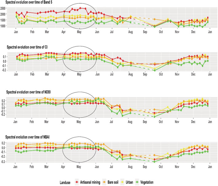
Artisanal and small-scale gold mining (ASGM) represents a significant economic activity for communities in developing countries. In southeastern Senegal, this activity has increased in recent years and has become the main source of income for the local population. However, it is also associated with negative environmental, social, and health impacts. Considering the recent development of ASGM in Senegal and the difficulties of the government in monitoring and regulating this activity, this article proposes a method for detecting and mapping ASGM sites in Senegal using Sentinel 2 data and the Google Earth Engine. Two artisanal mining sites in Senegal are selected to test this approach. Detection and mapping are achieved following a processing pipeline. Principal component analysis (PCA) is applied to determine the optimal period of the year for mapping. Separability and threshold (SEaTH) is used to determine the optimal bands or spectral indices to discriminate ASGM from other land use. Finally, automatic classification and mapping of the scenes are achieved with support vector machine (SVM) classifier. The results are then validated based on field observations. The PCA and examination of spectral signatures as a function of time indicate that the best period for discriminate ASGM sites against other types of land use is the end of dry season, when vegetation is minimal. The classification results are presented as a map with different categories of land use. This method could be applied to future Sentinel scenes to monitor the evolution of mining sites and may also be extrapolated to other relevant areas in the Sahel.
手工和小规模金矿开采(ASGM)是发展中国家社区的一项重要经济活动。在塞内加尔东南部,这项活动近年来有所增加,并已成为当地居民的主要收入来源。然而,它也带来了负面的环境、社会和健康影响。考虑到塞内加尔ASGM的近期发展以及政府在监测和监管这项活动方面的困难,本文提出了一种利用哨兵2号数据和谷歌地球引擎检测和绘制塞内加尔ASGM场地的方法。选择了塞内加尔的两个手工采矿场地来测试这种方法。检测和绘图是按照一个处理流程进行的。应用主成分分析(PCA)来确定一年中进行绘图的最佳时期。可分离性和阈值(SEaTH)用于确定区分ASGM与其他土地利用的最佳波段或光谱指数。最后,使用支持向量机(SVM)分类器实现场景的自动分类和绘图。然后根据实地观测对结果进行验证。PCA以及作为时间函数的光谱特征检查表明,将ASGM场地与其他类型土地利用区分开来的最佳时期是旱季末期,此时植被最少。分类结果以不同土地利用类别的地图呈现。这种方法可应用于未来的哨兵场景,以监测采矿场地的演变,也可推广到萨赫勒地区的其他相关区域。