• 文献检索
  • 文档翻译
  • 深度研究
  • 学术资讯
  • Suppr Zotero 插件Zotero 插件
  • 邀请有礼
  • 套餐&价格
  • 历史记录
应用&插件
Suppr Zotero 插件Zotero 插件浏览器插件Mac 客户端Windows 客户端微信小程序
定价
高级版会员购买积分包购买API积分包
服务
文献检索文档翻译深度研究API 文档MCP 服务
关于我们
关于 Suppr公司介绍联系我们用户协议隐私条款
关注我们

Suppr 超能文献

核心技术专利:CN118964589B侵权必究
粤ICP备2023148730 号-1Suppr @ 2026

文献检索

告别复杂PubMed语法,用中文像聊天一样搜索,搜遍4000万医学文献。AI智能推荐,让科研检索更轻松。

立即免费搜索

文件翻译

保留排版,准确专业,支持PDF/Word/PPT等文件格式,支持 12+语言互译。

免费翻译文档

深度研究

AI帮你快速写综述,25分钟生成高质量综述,智能提取关键信息,辅助科研写作。

立即免费体验

验证一种用于城市道路网络的低成本路面监测惯性系统。

Validation of a Low-Cost Pavement Monitoring Inertial-Based System for Urban Road Networks.

机构信息

Department of Civil, Constructional and Environmental Engineering, Sapienza University, Via Eudossiana, 18-00184 Rome, Italy.

Department of Transportation Engineering, Polytechnic School of the University of São Paulo, Avenida Professor Almeida Prado, Travessa 2, 83-05508010 São Paulo, Brazil.

出版信息

Sensors (Basel). 2021 Apr 30;21(9):3127. doi: 10.3390/s21093127.

DOI:10.3390/s21093127
PMID:33946324
原文链接:https://pmc.ncbi.nlm.nih.gov/articles/PMC8125624/
Abstract

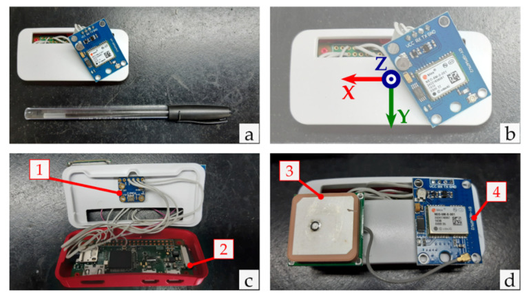
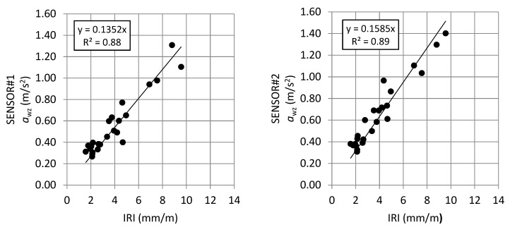
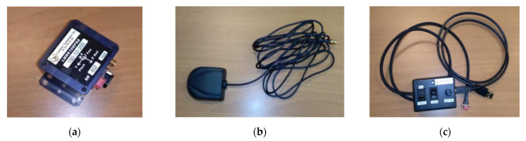
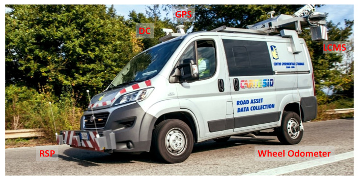
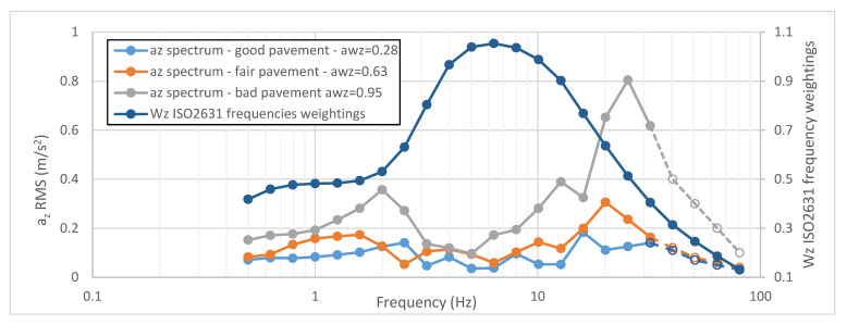
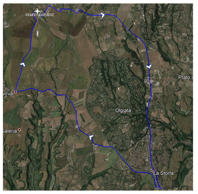
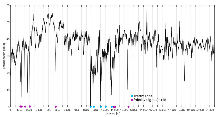
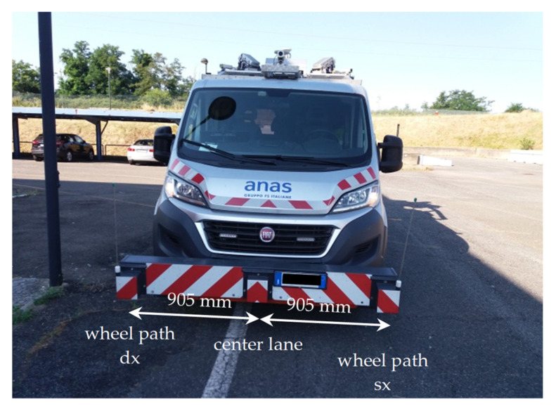
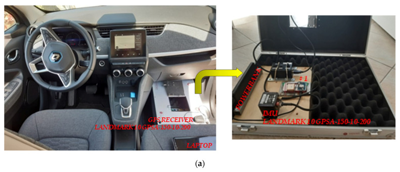
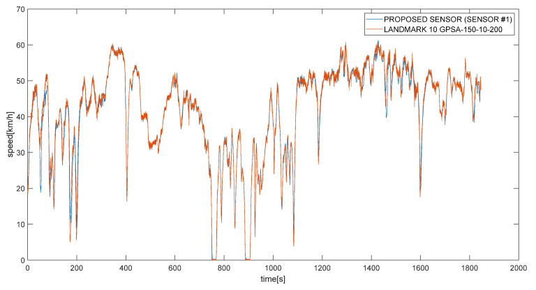
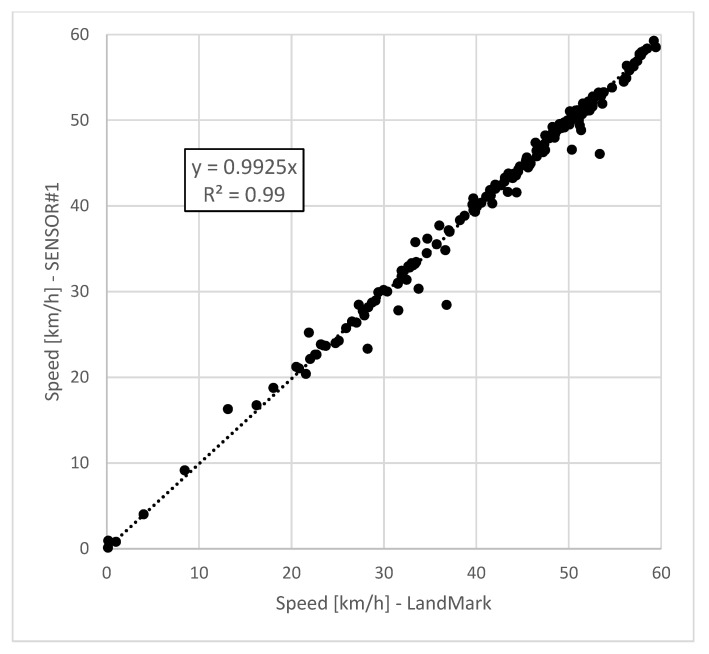
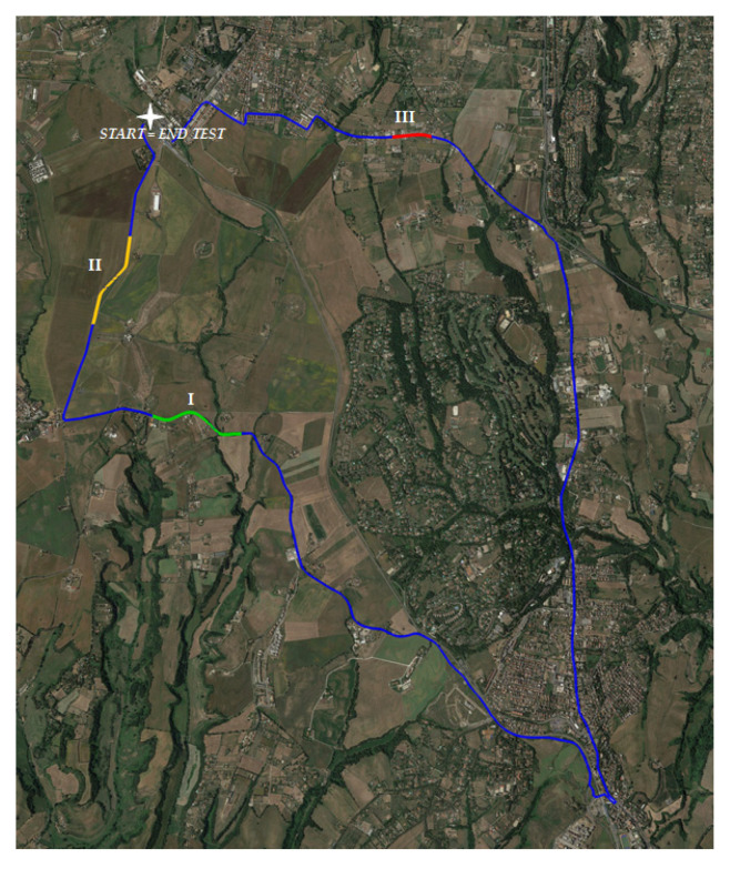
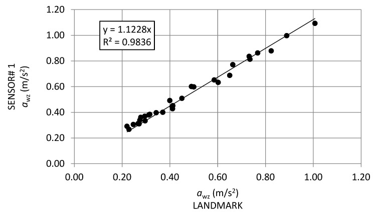
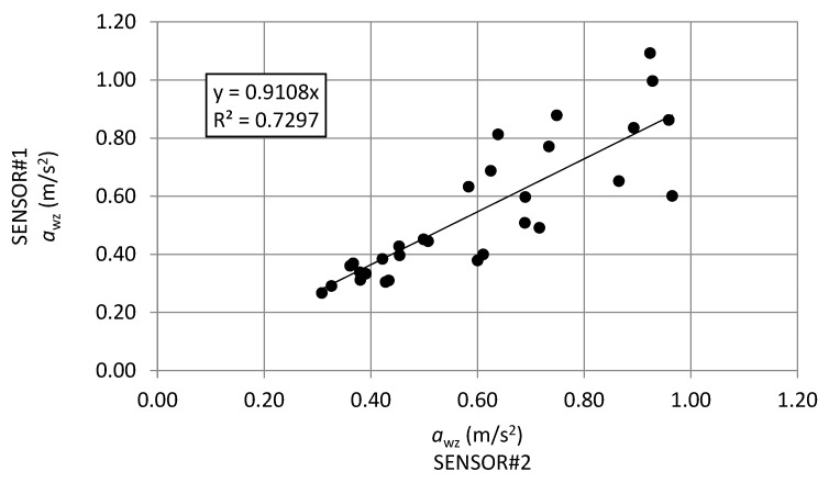
Road networks are monitored to evaluate their decay level and the performances regarding ride comfort, vehicle rolling noise, fuel consumption, etc. In this study, a novel inertial sensor-based system is proposed using a low-cost inertial measurement unit (IMU) and a global positioning system (GPS) module, which are connected to a Raspberry Pi Zero W board and embedded inside a vehicle to indirectly monitor the road condition. To assess the level of pavement decay, the comfort index defined by the ISO 2631 standard was used. Considering 21 km of roads with different levels of pavement decay, validation measurements were performed using the novel sensor, a high performance inertial based navigation sensor, and a road surface profiler. Therefore, comparisons between determined with accelerations measured on the two different inertial sensors are made; in addition, also correlations between , and typical pavement indicators such as international roughness index, and ride number were also performed. The results showed very good correlations between the values calculated with the two inertial devices (R = 0.98). In addition, the correlations between values and the typical pavement indices showed promising results (R = 0.83-0.90). The proposed sensor may be assumed as a reliable and easy-to-install method to assess the pavement conditions in urban road networks, since the use of traditional systems is difficult and/or expensive.

摘要

道路网络被监测以评估其衰减水平和行驶舒适性、车辆滚动噪声、燃料消耗等方面的性能。在这项研究中,提出了一种使用低成本惯性测量单元 (IMU) 和全球定位系统 (GPS) 模块的新型惯性传感器系统,该系统连接到 Raspberry Pi Zero W 板并嵌入车辆内部,以间接监测道路状况。为了评估路面衰减程度,使用 ISO 2631 标准定义的舒适指数 。考虑到 21 公里不同路面衰减程度的道路,使用新型传感器、高性能惯性导航传感器和路面剖面仪进行了验证测量。因此,对在两个不同的惯性传感器上测量的加速度确定的 进行了比较;此外,还对 与国际粗糙度指数和行驶数等典型路面指标之间进行了相关性分析。结果表明,两个惯性设备计算的 值之间具有很好的相关性(R = 0.98)。此外, 值与典型路面指数之间的相关性也显示出了有希望的结果(R = 0.83-0.90)。由于传统系统难以使用和/或昂贵,因此可以假设所提出的传感器是评估城市道路网络中路面状况的可靠且易于安装的方法。

https://cdn.ncbi.nlm.nih.gov/pmc/blobs/4edc/8125624/124f9f7a4935/sensors-21-03127-g015a.jpg
https://cdn.ncbi.nlm.nih.gov/pmc/blobs/4edc/8125624/c93356e4ee45/sensors-21-03127-g001.jpg
https://cdn.ncbi.nlm.nih.gov/pmc/blobs/4edc/8125624/6dce6e20786c/sensors-21-03127-g002.jpg
https://cdn.ncbi.nlm.nih.gov/pmc/blobs/4edc/8125624/b7563c39556d/sensors-21-03127-g003.jpg
https://cdn.ncbi.nlm.nih.gov/pmc/blobs/4edc/8125624/e3fcb10bf604/sensors-21-03127-g004.jpg
https://cdn.ncbi.nlm.nih.gov/pmc/blobs/4edc/8125624/6da73ec1b266/sensors-21-03127-g005.jpg
https://cdn.ncbi.nlm.nih.gov/pmc/blobs/4edc/8125624/2bbaab9e2f1b/sensors-21-03127-g006.jpg
https://cdn.ncbi.nlm.nih.gov/pmc/blobs/4edc/8125624/4c98fefdd016/sensors-21-03127-g007.jpg
https://cdn.ncbi.nlm.nih.gov/pmc/blobs/4edc/8125624/77c72015f268/sensors-21-03127-g008a.jpg
https://cdn.ncbi.nlm.nih.gov/pmc/blobs/4edc/8125624/d9b7129d05db/sensors-21-03127-g009.jpg
https://cdn.ncbi.nlm.nih.gov/pmc/blobs/4edc/8125624/01c9ce26bf08/sensors-21-03127-g010.jpg
https://cdn.ncbi.nlm.nih.gov/pmc/blobs/4edc/8125624/0c27a6edd738/sensors-21-03127-g011.jpg
https://cdn.ncbi.nlm.nih.gov/pmc/blobs/4edc/8125624/a878bce47e39/sensors-21-03127-g012.jpg
https://cdn.ncbi.nlm.nih.gov/pmc/blobs/4edc/8125624/30da4051cc3a/sensors-21-03127-g013.jpg
https://cdn.ncbi.nlm.nih.gov/pmc/blobs/4edc/8125624/63aaabe989c8/sensors-21-03127-g014.jpg
https://cdn.ncbi.nlm.nih.gov/pmc/blobs/4edc/8125624/124f9f7a4935/sensors-21-03127-g015a.jpg

相似文献

1
Validation of a Low-Cost Pavement Monitoring Inertial-Based System for Urban Road Networks.验证一种用于城市道路网络的低成本路面监测惯性系统。
Sensors (Basel). 2021 Apr 30;21(9):3127. doi: 10.3390/s21093127.
2
Development of a GIS-Based Methodology for the Management of Stone Pavements Using Low-Cost Sensors.基于 GIS 的低成本传感器在石质铺地管理中的应用方法开发。
Sensors (Basel). 2022 Aug 31;22(17):6560. doi: 10.3390/s22176560.
3
Pavement Quality Evaluation Using Connected Vehicle Data.利用车联网数据进行路面质量评价。
Sensors (Basel). 2022 Nov 24;22(23):9109. doi: 10.3390/s22239109.
4
Abnormal Pavement Condition Detection with Vehicle Posture Data Considering Speed Variations.基于考虑速度变化的车辆姿态数据的异常路面状况检测
Sensors (Basel). 2024 Jul 14;24(14):4555. doi: 10.3390/s24144555.
5
Estimating Pavement Roughness by Fusing Color and Depth Data Obtained from an Inexpensive RGB-D Sensor.利用廉价的 RGB-D 传感器获取的颜色和深度数据估算路面粗糙度。
Sensors (Basel). 2019 Apr 6;19(7):1655. doi: 10.3390/s19071655.
6
ROADS-Rover for Bituminous Pavement Distress Survey: An Unmanned Ground Vehicle (UGV) Prototype for Pavement Distress Evaluation.ROADS-Rover 用于沥青路面损坏调查:用于路面损坏评估的无人地面车辆 (UGV) 原型。
Sensors (Basel). 2022 Apr 29;22(9):3414. doi: 10.3390/s22093414.
7
Smart Sensing of Pavement Temperature Based on Low-Cost Sensors and V2I Communications.基于低成本传感器和车对基础设施通信的路面温度智能感知。
Sensors (Basel). 2018 Jun 29;18(7):2092. doi: 10.3390/s18072092.
8
Error and Performance Analysis of MEMS-based Inertial Sensors with a Low-cost GPS Receiver.基于低成本GPS接收器的MEMS惯性传感器的误差与性能分析
Sensors (Basel). 2008 Mar 29;8(4):2240-2261. doi: 10.3390/s8042240.
9
Zigbee-Based Wireless Sensor Network of MEMS Accelerometers for Pavement Monitoring.用于路面监测的基于Zigbee的MEMS加速度计无线传感器网络
Sensors (Basel). 2024 Oct 9;24(19):6487. doi: 10.3390/s24196487.
10
IMU-Based Virtual Road Profile Sensor for Vehicle Localization.基于 IMU 的车辆定位虚拟道路剖面传感器。
Sensors (Basel). 2018 Oct 7;18(10):3344. doi: 10.3390/s18103344.

引用本文的文献

1
Exploring single-head and multi-head CNN and LSTM-based models for road surface classification using on-board vehicle multi-IMU data.利用车载多惯性测量单元(IMU)数据,探索基于单头和多头卷积神经网络(CNN)以及长短期记忆网络(LSTM)的路面分类模型。
Sci Rep. 2025 Jul 9;15(1):24595. doi: 10.1038/s41598-025-10573-2.
2
A Vibration-Based Methodology to Monitor Road Surface: A Process to Overcome the Speed Effect.一种基于振动的路面监测方法:克服速度影响的过程。
Sensors (Basel). 2024 Jan 31;24(3):925. doi: 10.3390/s24030925.
3
A Robotized Raspberry-Based System for Pothole 3D Reconstruction and Mapping.

本文引用的文献

1
Assessing and Mapping of Road Surface Roughness based on GPS and Accelerometer Sensors on Bicycle-Mounted Smartphones.基于自行车搭载智能手机上的全球定位系统(GPS)和加速度计传感器的路面粗糙度评估与测绘
Sensors (Basel). 2018 Mar 19;18(3):914. doi: 10.3390/s18030914.
2
Sensor integration in a low cost land mobile mapping system.低成本陆地移动测绘系统中的传感器集成。
Sensors (Basel). 2012;12(3):2935-53. doi: 10.3390/s120302935. Epub 2012 Mar 2.
一种基于树莓派的用于坑洼三维重建与测绘的自动化系统。
Sensors (Basel). 2023 Jun 24;23(13):5860. doi: 10.3390/s23135860.
4
Smart Streets as a Cyber-Physical Social Platform: A Conceptual Framework.智能街道作为一种信息物理社会平台:概念框架。
Sensors (Basel). 2023 Jan 26;23(3):1399. doi: 10.3390/s23031399.
5
Pavement Distress Estimation via Signal on Graph Processing.基于图处理的路面损坏评估。
Sensors (Basel). 2022 Nov 25;22(23):9183. doi: 10.3390/s22239183.
6
Development of a GIS-Based Methodology for the Management of Stone Pavements Using Low-Cost Sensors.基于 GIS 的低成本传感器在石质铺地管理中的应用方法开发。
Sensors (Basel). 2022 Aug 31;22(17):6560. doi: 10.3390/s22176560.
7
Development and Testing of a 5G Multichannel Intelligent Seismograph Based on Raspberry Pi.基于树莓派的5G多通道智能地震仪的开发与测试
Sensors (Basel). 2022 May 31;22(11):4193. doi: 10.3390/s22114193.
8
Technical Proposal for Monitoring Thermal and Mechanical Stresses of a Runway Pavement.跑道路面热和机械应力监测技术提案。
Sensors (Basel). 2021 Oct 13;21(20):6797. doi: 10.3390/s21206797.