• 文献检索
  • 文档翻译
  • 深度研究
  • 学术资讯
  • Suppr Zotero 插件Zotero 插件
  • 邀请有礼
  • 套餐&价格
  • 历史记录
应用&插件
Suppr Zotero 插件Zotero 插件浏览器插件Mac 客户端Windows 客户端微信小程序
定价
高级版会员购买积分包购买API积分包
服务
文献检索文档翻译深度研究API 文档MCP 服务
关于我们
关于 Suppr公司介绍联系我们用户协议隐私条款
关注我们

Suppr 超能文献

核心技术专利:CN118964589B侵权必究
粤ICP备2023148730 号-1Suppr @ 2026

文献检索

告别复杂PubMed语法,用中文像聊天一样搜索,搜遍4000万医学文献。AI智能推荐,让科研检索更轻松。

立即免费搜索

文件翻译

保留排版,准确专业,支持PDF/Word/PPT等文件格式,支持 12+语言互译。

免费翻译文档

深度研究

AI帮你快速写综述,25分钟生成高质量综述,智能提取关键信息,辅助科研写作。

立即免费体验

确定与政策相关的指标,以评估景观植被模式,为多用途公共土地的规划和管理提供信息。

Identifying Policy-relevant Indicators for Assessing Landscape Vegetation Patterns to Inform Planning and Management on Multiple-use Public Lands.

机构信息

U.S. Geological Survey, Fort Collins Science Center, 2150 Centre Ave. Building C, Fort Collins, CO, 80526-8118, USA.

Bureau of Land Management, Colorado State Office, 2850 Youngfield St, Lakewood, CO, 80215, USA.

出版信息

Environ Manage. 2021 Sep;68(3):426-443. doi: 10.1007/s00267-021-01493-8. Epub 2021 Jun 26.

DOI:10.1007/s00267-021-01493-8
PMID:34175960
原文链接:https://pmc.ncbi.nlm.nih.gov/articles/PMC8384788/
Abstract

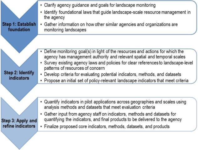
Understanding the structure and composition of landscapes can empower agencies to effectively manage public lands for multiple uses while sustaining land health. Many landscape metrics exist, but they are not often used in public land decision-making. Our objectives were to (1) develop and (2) apply a process for identifying a core set of indicators that public land managers can use to understand landscape-level resource patterns on and around public lands. We first developed a process for identifying indicators that are grounded in policy, feasible to quantify using existing data and resources, and useful for managers. We surveyed landscape monitoring efforts by other agencies, gathered science and agency input on monitoring goals, and quantified the prevalence of potential indicators in agency land health standards to identify five landscape indicators: amount, distribution, patch size, structural connectivity, and diversity of vegetation types. We then conducted pilot applications in four bureau of land management (BLM) field offices in Arizona, California, and Colorado to refine procedures for quantifying the indicators and assess the utility of the indicators for managers. Results highlighted the dominance of upland and the limited extent of riparian/wetland vegetation communities, moderate connectivity of priority vegetation patches, and lower diversity of native vegetation types on BLM compared to non-BLM lands. Agency staff can use the indicators to inform the development of quantitative resource management objectives in land use plans, evaluate progress in meeting those objectives, quantify potential impacts of proposed actions, and as a foundation for an all-lands approach to landscape-level management across public lands.

摘要

了解景观的结构和组成可以使机构能够有效地管理公共土地以实现多种用途,同时维持土地健康。有许多景观指标存在,但它们在公共土地决策中并不常用。我们的目标是(1)制定和(2)应用一种识别核心指标集的过程,公共土地管理者可以使用这些指标来了解公共土地及其周围的景观资源模式。我们首先制定了一个识别指标的过程,这些指标基于政策,使用现有数据和资源进行量化是可行的,并且对管理者有用。我们调查了其他机构的景观监测工作,收集了关于监测目标的科学和机构投入,并量化了潜在指标在机构土地健康标准中的出现频率,以确定五个景观指标:数量、分布、斑块大小、结构连接性和植被类型多样性。然后,我们在亚利桑那州、加利福尼亚州和科罗拉多州的四个土地管理局(BLM)实地办公室进行了试点应用,以完善量化指标的程序,并评估指标对管理者的实用性。结果突出了旱地的主导地位,以及滨水/湿地植被群落的有限范围,优先植被斑块的中等连接性,以及 BLM 土地上原生植被类型的多样性较低。机构工作人员可以使用这些指标来为土地利用规划中制定定量资源管理目标提供信息,评估在实现这些目标方面的进展,量化拟议行动的潜在影响,并为公共土地的全土地景观管理方法奠定基础。

https://cdn.ncbi.nlm.nih.gov/pmc/blobs/ba67/8384788/a320ff010ca3/267_2021_1493_Fig6_HTML.jpg
https://cdn.ncbi.nlm.nih.gov/pmc/blobs/ba67/8384788/27649d4bbe10/267_2021_1493_Fig1_HTML.jpg
https://cdn.ncbi.nlm.nih.gov/pmc/blobs/ba67/8384788/64fe58362253/267_2021_1493_Fig2_HTML.jpg
https://cdn.ncbi.nlm.nih.gov/pmc/blobs/ba67/8384788/3141a9b8e1bb/267_2021_1493_Fig3_HTML.jpg
https://cdn.ncbi.nlm.nih.gov/pmc/blobs/ba67/8384788/56d0493d6973/267_2021_1493_Fig4_HTML.jpg
https://cdn.ncbi.nlm.nih.gov/pmc/blobs/ba67/8384788/4e3c658205b2/267_2021_1493_Fig5_HTML.jpg
https://cdn.ncbi.nlm.nih.gov/pmc/blobs/ba67/8384788/a320ff010ca3/267_2021_1493_Fig6_HTML.jpg

相似文献

1
Identifying Policy-relevant Indicators for Assessing Landscape Vegetation Patterns to Inform Planning and Management on Multiple-use Public Lands.确定与政策相关的指标,以评估景观植被模式,为多用途公共土地的规划和管理提供信息。
Environ Manage. 2021 Sep;68(3):426-443. doi: 10.1007/s00267-021-01493-8. Epub 2021 Jun 26.
2
Assessing effects of land use on landscape connectivity: loss and fragmentation of western U.S. forests.评估土地利用对景观连通性的影响:美国西部森林的损失和破碎化。
Ecol Appl. 2011 Oct;21(7):2445-58. doi: 10.1890/10-1701.1.
3
Managing Carbon on Federal Public Lands: Opportunities and Challenges in Southwestern Colorado.管理联邦公共土地上的碳:科罗拉多州西南部的机遇与挑战
Environ Manage. 2016 Aug;58(2):283-96. doi: 10.1007/s00267-016-0714-2. Epub 2016 Jun 7.
4
Quantifying Ecological Integrity of Terrestrial Systems to Inform Management of Multiple-Use Public Lands in the United States.量化陆地系统的生态完整性,为美国多用途公共土地的管理提供信息。
Environ Manage. 2019 Jul;64(1):1-19. doi: 10.1007/s00267-019-01163-w. Epub 2019 Apr 13.
5
Evaluating and using existing models to map probable suitable habitat for rare plants to inform management of multiple-use public lands in the California desert.评估和利用现有模型来绘制稀有植物可能适宜生境的地图,为加利福尼亚沙漠多种用途公共土地的管理提供信息。
PLoS One. 2019 Apr 19;14(4):e0214099. doi: 10.1371/journal.pone.0214099. eCollection 2019.
6
Managing United States public lands in response to climate change: a view from the ground up.应对气候变化管理美国公共土地:自下而上的观点。
Environ Manage. 2012 May;49(5):954-67. doi: 10.1007/s00267-012-9829-2. Epub 2012 Mar 22.
7
Landscape changes in the Cerrado: Challenges of land clearing, fragmentation and land tenure for biological conservation.塞拉多景观变化:土地开垦、破碎化和土地保有权对生物保护的挑战。
Sci Total Environ. 2024 Jan 1;906:167581. doi: 10.1016/j.scitotenv.2023.167581. Epub 2023 Oct 7.
8
Legal ecotones: A comparative analysis of riparian policy protection in the Oregon Coast Range, USA.法律生态交错带:美国俄勒冈海岸山脉河岸政策保护的比较分析
J Environ Manage. 2017 Jul 15;197:206-220. doi: 10.1016/j.jenvman.2017.03.075. Epub 2017 Apr 4.
9
Anticipating forest and range land development in central Oregon (USA) for landscape analysis, with an example application involving mule deer.预测美国俄勒冈州中部的森林和草原土地开发情况,以涉及骡鹿的应用为例进行景观分析。
Environ Manage. 2010 May;45(5):974-84. doi: 10.1007/s00267-010-9470-x. Epub 2010 Mar 19.
10
Riparian vegetation as an indicator of riparian condition: Detecting departures from historic condition across the North American West.河岸植被作为河岸状况的指标:检测北美西部与历史状况的偏差。
J Environ Manage. 2017 Nov 1;202(Pt 2):447-460. doi: 10.1016/j.jenvman.2016.10.054. Epub 2016 Nov 10.