You Mou, Zou Zeduo, Zhao Wei, Zhang Wenwen, Fu Canfang
College of Geography and Environmental Science, Henan University, Kaifeng 475001, China.
Key Laboratory of Geospatial Technology for the Middle and Lower Yellow River Regions, Ministry of Education, College of Geography and Environmental Science, Henan University, Kaifeng 475001, China.
Heliyon. 2023 Feb 27;9(3):e13430. doi: 10.1016/j.heliyon.2023.e13430. eCollection 2023 Mar.
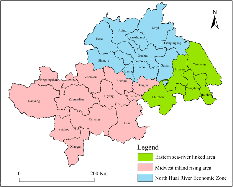
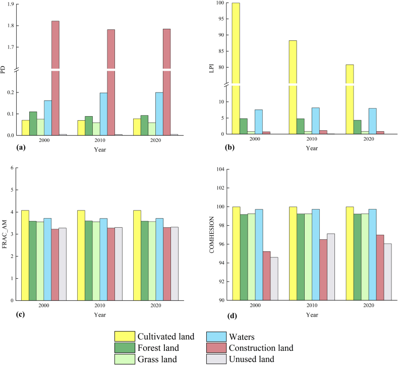
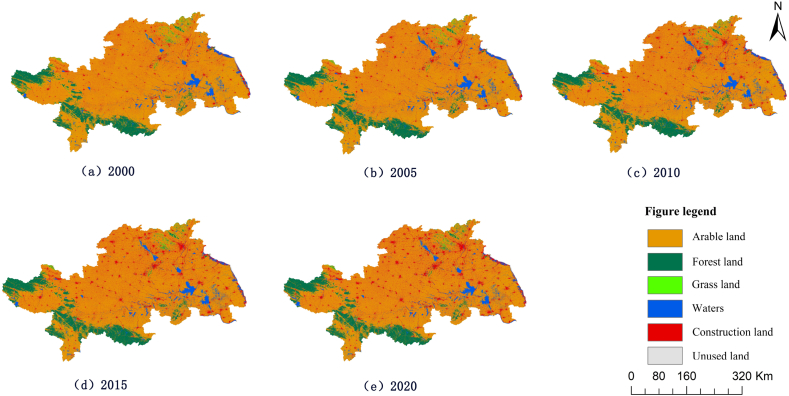
Exploring the relationship between land use change and landscape patterns can provide a basis for regional ecological management. In this paper, based on remote sensing images of the Huaihe River Ecological and Economic Zone for the years 2000, 2005, 2010, 2015 and 2020, the spatial and temporal evolution patterns of land use in the region were quantitatively described by using the methods of land use shift matrix and landscape pattern analysis. The relationship between land use change and landscape pattern was analyzed with the Grey Relation Analysis (GRA) model. The results show that: (1) the land use of the Huaihe River Ecological and Economic Zone has changed significantly in the past 20 years, with the conversion of arable land into construction and forest lands, in addition to the growth of water areas and a decline in the areas of arable land, grassland and unused land. (2) The landscape pattern fragmentation of each type of land in the study area from 2000 to 2020 fluctuated and decreased, and the landscape connectivity and landscape diversity increased significantly. (3) The GRA model shows that construction, arable and forest lands played the most significant role in the change of landscape pattern of the Huaihe River Ecological and Economic Zone. Countermeasures are proposed to better coordinate and optimize the relationship between spatial development and landscape pattern for the Huaihe River ecological and economic Zone.
探究土地利用变化与景观格局之间的关系可为区域生态管理提供依据。本文基于2000年、2005年、2010年、2015年和2020年淮河生态经济带的遥感影像,运用土地利用转移矩阵和景观格局分析方法,定量描述了该区域土地利用的时空演变格局。采用灰色关联分析(GRA)模型分析了土地利用变化与景观格局之间的关系。结果表明:(1)淮河生态经济带在过去20年土地利用变化显著,除水域面积增加以及耕地、草地和未利用地面积减少外,还有耕地向建设用地和林地的转变。(2)2000—2020年研究区内各类土地的景观格局破碎化呈波动下降趋势,景观连通性和景观多样性显著增加。(3)灰色关联分析(GRA)模型表明,建设用地、耕地和林地对淮河生态经济带景观格局变化的影响最为显著。针对淮河生态经济带,提出了更好地协调和优化空间开发与景观格局关系的对策。