Ali Musah, Moses Asori, Nakua Emmanuel Kweku, Punguyire Damien, Cheabu Benjamin Spears Ngmekpele, Avevor Patrick Mawupemor, Basit Kassim Abdul
Kwame Nkrumah University of Science and Technology, Department of Epidemiology and Biostatistics, Kumasi, Ghana.
University of North Carolina, Department of Geography, Charlotte, United States.
Clin Infect Pract. 2022 Nov;16:100160. doi: 10.1016/j.clinpr.2022.100160.
The use of a Geographic Information System in identifying meningitis hotspots in the Upper West Region (UWR) remains underutilized, making spatial targeting of meningitis hotspots difficult. We therefore utilized surveillance data enabled with GIS technology to target meningitis outbreaks in the UWR.
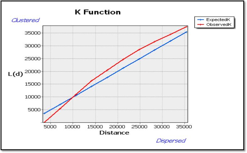
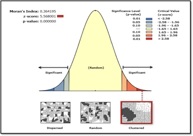
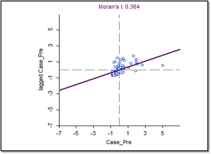
Secondary data analysis was conducted in the study. The dynamics of bacterial meningitis in space and time were studied using epidemiological data from 2018 to 2020. Spot map and choropleths were used to depict the distribution of cases in the region. Moran's I statistics were used to assess spatial autocorrelation. Getis-Ord Gi*(d) and Anselin Local Moran's statistics were used to identify hotspots and spatial outliers within the study area. A Geographic Weighted Regression model was also used to examine how socio bio-climatic conditions influence the spread of meningitis.
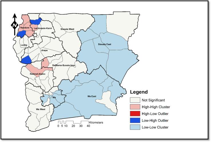
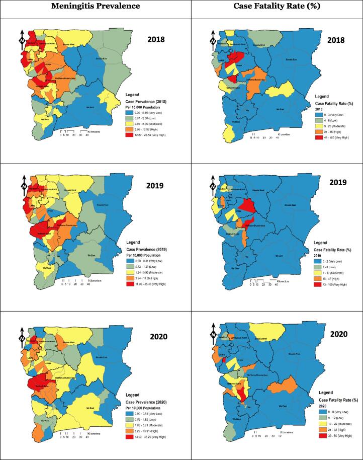
There were 1176 cases of bacterial meningitis, 118 deaths, and 1058 survivors between 2018 and 2020. Nandom municipality had the highest Attack Rate (AR) at 492/100,000 persons, followed by Nadowli-Kaleo district at 314/100,000 persons. Jirapa had the highest case fatality rate (CFR) at 17%. The spatio-temporal analysis showed spatial diffusion of meningitis prevalence from the western half of the UWR to the east with a significant number of hotpots and cluster outliers.
Bacterial meningitis does not occur at random. Populations (10.9%) under sub-districts identified as hotspots are exceptionally at higher risk of outbreaks. Targeted interventions should be directed towards clustered hotspots, focusing on zones with low prevalence fenced off by high prevalence zones.
地理信息系统在上西部地区(UWR)识别脑膜炎热点地区方面的应用仍未得到充分利用,这使得对脑膜炎热点地区进行空间定位变得困难。因此,我们利用地理信息系统技术支持的监测数据来定位上西部地区的脑膜炎疫情。
本研究采用二次数据分析。利用2018年至2020年的流行病学数据研究细菌性脑膜炎在空间和时间上的动态变化。使用点状地图和分级统计图来描绘该地区病例的分布情况。使用莫兰指数统计来评估空间自相关性。使用Getis-Ord Gi*(d)和安塞林局部莫兰统计来识别研究区域内的热点地区和空间异常值。还使用地理加权回归模型来研究社会生物气候条件如何影响脑膜炎的传播。
2018年至2020年期间,共有1176例细菌性脑膜炎病例,118例死亡,1058例幸存者。南登市的发病率最高,为492/10万人,其次是纳多利-卡莱奥区,为314/10万人。吉拉帕的病死率最高,为17%。时空分析显示,脑膜炎患病率从UWR的西半部向东呈空间扩散,有大量热点地区和聚集异常值。
细菌性脑膜炎并非随机发生。被确定为热点地区的分区内的人群(10.9%)爆发疫情的风险特别高。有针对性的干预措施应针对聚集的热点地区,重点关注被高患病率地区包围的低患病率地区。