Kwapień Karolina, Lasota Patrycja, Kędzierski Michał, Walczykowski Piotr
Department of IMINT, Faculty of Civil Engineering and Geodesy, Military University of Technology, 00-908 Warsaw, Poland.
Sensors (Basel). 2023 Jul 6;23(13):6192. doi: 10.3390/s23136192.
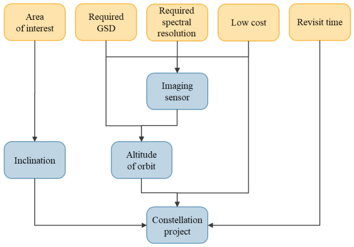
The quality of inland waters has a significant influence on human life and the functioning of the environment. The disasters that result from water pollution may cause major financial losses and lead to irreversible changes in the ecosystem, such as the dying out of endemic species of plants and animals. Quick detection of pollution sources may minimise those negative effects and reduce the costs of their elimination. The study presents a constellation design that provides imagery in the optic range and that might supplement the point water quality measurements that are conducted in situ. The area of interest was the southern catchment of the Baltic Sea and the main rivers in the region. The requirements for the designed mission were defined in reference to the remote sensing needs concerning the monitoring of water quality, the characteristics of the analysed area, and weather conditions. Based on these requirements, the Simera Sense MultiScape100 CIS sensor and the M6P nanosatellite manufactured by NanoAvionics were selected. The authors proposed a process for selecting the optimum orbit, taking into account the area of interest, the possibilities of the satellite platform, and of the sensor's optics. As a result of the analyses, four concepts of creating a constellation were presented. Each constellation consisted of four nanosatellites. The designs were then subjected to performance analysis, considering the lighting limitations. Among the proposed systems, the constellation designed by the authors was distinguished; it used four orbital planes and achieved the coverage and availability of imagery in the time that was best suited to monitoring the waters. Thanks to a small number of platforms, the costs of the mission are relatively low, and it might significantly improve awareness of the current state of surface waters in the southern catchment of the Baltic Sea.
内陆水域的水质对人类生活和环境功能有着重大影响。水污染导致的灾害可能造成重大经济损失,并导致生态系统发生不可逆转的变化,如本地动植物物种灭绝。快速检测污染源可将这些负面影响降至最低,并降低消除污染的成本。该研究提出了一种星座设计,可提供光学波段的图像,以补充现场进行的点水质测量。研究区域为波罗的海南部集水区及该地区的主要河流。根据水质监测的遥感需求、分析区域的特点和天气条件,确定了所设计任务的要求。基于这些要求,选择了Simera Sense MultiScape100 CIS传感器和NanoAvionics制造的M6P纳米卫星。作者提出了一种选择最佳轨道的方法,同时考虑了感兴趣区域、卫星平台的能力和传感器光学系统的能力。分析结果提出了四种创建星座的方案。每个星座由四颗纳米卫星组成。然后对这些设计进行性能分析,考虑光照限制。在所提出的系统中,作者设计的星座脱颖而出;它使用四个轨道平面,在最适合监测水域的时间内实现了图像覆盖和可用性。由于平台数量较少,任务成本相对较低,并且可能显著提高对波罗的海南部集水区地表水当前状况的认识。