• 文献检索
  • 文档翻译
  • 深度研究
  • 学术资讯
  • Suppr Zotero 插件Zotero 插件
  • 邀请有礼
  • 套餐&价格
  • 历史记录
应用&插件
Suppr Zotero 插件Zotero 插件浏览器插件Mac 客户端Windows 客户端微信小程序
定价
高级版会员购买积分包购买API积分包
服务
文献检索文档翻译深度研究API 文档MCP 服务
关于我们
关于 Suppr公司介绍联系我们用户协议隐私条款
关注我们

Suppr 超能文献

核心技术专利:CN118964589B侵权必究
粤ICP备2023148730 号-1Suppr @ 2026

文献检索

告别复杂PubMed语法,用中文像聊天一样搜索,搜遍4000万医学文献。AI智能推荐,让科研检索更轻松。

立即免费搜索

文件翻译

保留排版,准确专业,支持PDF/Word/PPT等文件格式,支持 12+语言互译。

免费翻译文档

深度研究

AI帮你快速写综述,25分钟生成高质量综述,智能提取关键信息,辅助科研写作。

立即免费体验

基于物联网大数据分析的无人机辅助灾后通信覆盖优化

Unmanned Aerial Vehicle Assisted Post-Disaster Communication Coverage Optimization Based on Internet of Things Big Data Analysis.

作者信息

Yang Biao, Xiong Xuanrui, Liu He, Jia Yumei, Gao Yunli, Tolba Amr, Zhang Xingguo

机构信息

School of Communication and Information Engineering, Chongqing University of Posts and Telecommunications, Chongqing 400065, China.

School of Software, Dalian University of Technology, Dalian 116024, China.

出版信息

Sensors (Basel). 2023 Jul 29;23(15):6795. doi: 10.3390/s23156795.

DOI:10.3390/s23156795
PMID:37571578
原文链接:https://pmc.ncbi.nlm.nih.gov/articles/PMC10422493/
Abstract

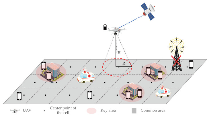
The rapid development of Internet of Things (IoT) communication devices has brought about significant convenience. However, simultaneously, the destruction of communication infrastructure in emergency situations often leads to communication disruptions and challenges in information dissemination, severely impacting rescue operations and the safety of the affected individuals. To address this challenge, IoT big data analytics and unmanned aerial vehicle (UAV) technologies have emerged as key elements in the solution. By analyzing large-scale sensor data, user behavior, and communication traffic, IoT big data analytics can provide real-time communication demand prediction and network optimization strategies, offering decision support for post-disaster communication reconstruction. Given the unique characteristics of post-disaster scenarios, this paper proposes a UAV-assisted communication coverage strategy based on IoT big data analytics. This strategy employs UAVs in a cruising manner to assist in communication by partitioning the target area into multiple cells, each satisfying the minimum data requirements for user communication. Depending on the distribution characteristics of users, flight-communication or hover-communication protocols are selectively employed to support communication. By optimizing the UAV's flight speed and considering the coverage index, fairness index, and average energy efficiency of the mission's target area, the Inner Spiral Cruise Communication Coverage (IS-CCC) algorithm is proposed to plan the UAV's cruising trajectory and achieve UAV-based communication coverage. Simulation results demonstrate that this strategy can achieve energy-efficient cruising communication coverage in regions with complex user distributions, thereby reducing energy consumption in UAV-based communication.

摘要

物联网(IoT)通信设备的快速发展带来了极大的便利。然而,与此同时,紧急情况下通信基础设施的破坏往往会导致通信中断以及信息传播方面的挑战,严重影响救援行动和受灾人员的安全。为应对这一挑战,物联网大数据分析和无人机(UAV)技术已成为解决方案的关键要素。通过分析大规模传感器数据、用户行为和通信流量,物联网大数据分析可以提供实时通信需求预测和网络优化策略,为灾后通信重建提供决策支持。鉴于灾后场景的独特特征,本文提出了一种基于物联网大数据分析的无人机辅助通信覆盖策略。该策略采用无人机巡航方式,通过将目标区域划分为多个小区来辅助通信,每个小区满足用户通信的最小数据需求。根据用户的分布特征,选择性地采用飞行通信或悬停通信协议来支持通信。通过优化无人机的飞行速度,并考虑任务目标区域的覆盖指数、公平指数和平均能量效率,提出了内螺旋巡航通信覆盖(IS-CCC)算法来规划无人机的巡航轨迹,实现基于无人机的通信覆盖。仿真结果表明,该策略能够在用户分布复杂的区域实现节能巡航通信覆盖,从而降低基于无人机通信的能耗。

https://cdn.ncbi.nlm.nih.gov/pmc/blobs/55b0/10422493/a9f6281ae1a1/sensors-23-06795-g008.jpg
https://cdn.ncbi.nlm.nih.gov/pmc/blobs/55b0/10422493/728b8c16bd7a/sensors-23-06795-g001.jpg
https://cdn.ncbi.nlm.nih.gov/pmc/blobs/55b0/10422493/611ae7c31d4c/sensors-23-06795-g002.jpg
https://cdn.ncbi.nlm.nih.gov/pmc/blobs/55b0/10422493/eff3dfa6cdfb/sensors-23-06795-g003.jpg
https://cdn.ncbi.nlm.nih.gov/pmc/blobs/55b0/10422493/040713893ffe/sensors-23-06795-g004.jpg
https://cdn.ncbi.nlm.nih.gov/pmc/blobs/55b0/10422493/1d876a01da02/sensors-23-06795-g005.jpg
https://cdn.ncbi.nlm.nih.gov/pmc/blobs/55b0/10422493/ae777378af29/sensors-23-06795-g006.jpg
https://cdn.ncbi.nlm.nih.gov/pmc/blobs/55b0/10422493/2c5c8f7e7ef5/sensors-23-06795-g007.jpg
https://cdn.ncbi.nlm.nih.gov/pmc/blobs/55b0/10422493/a9f6281ae1a1/sensors-23-06795-g008.jpg

相似文献

1
Unmanned Aerial Vehicle Assisted Post-Disaster Communication Coverage Optimization Based on Internet of Things Big Data Analysis.基于物联网大数据分析的无人机辅助灾后通信覆盖优化
Sensors (Basel). 2023 Jul 29;23(15):6795. doi: 10.3390/s23156795.
2
Energy-Efficient Trajectory Planning for Smart Sensing in IoT Networks Using Quadrotor UAVs.基于四旋翼无人机的物联网网络智能感知节能轨迹规划
Sensors (Basel). 2022 Nov 11;22(22):8729. doi: 10.3390/s22228729.
3
UAV-Aided Dual-User Wireless Power Transfer: 3D Trajectory Design and Energy Optimization.UAV 辅助双用户无线功率传输:三维轨迹设计与能量优化。
Sensors (Basel). 2023 Mar 10;23(6):2994. doi: 10.3390/s23062994.
4
UAV Trajectory Optimization in a Post-Disaster Area Using Dual Energy-Aware Bandits.利用双能量感知强盗算法进行灾后区域的无人机轨迹优化。
Sensors (Basel). 2023 Jan 26;23(3):1402. doi: 10.3390/s23031402.
5
LoRa Communications as an Enabler for Internet of Drones towards Large-Scale Livestock Monitoring in Rural Farms.LoRa 通信作为无人机物联网在农村农场大规模牲畜监测中的使能技术。
Sensors (Basel). 2021 Jul 26;21(15):5044. doi: 10.3390/s21155044.
6
Trajectory Design for Multi-UAV-Aided Wireless Power Transfer toward Future Wireless Systems.面向未来无线系统的多无人机辅助无线电能传输轨迹设计
Sensors (Basel). 2022 Sep 10;22(18):6859. doi: 10.3390/s22186859.
7
Data Gathering and Energy Transfer Dilemma in UAV-Assisted Flying Access Network for IoT.物联网中无人机辅助飞临接入网的数据收集和能量转移困境。
Sensors (Basel). 2018 May 11;18(5):1519. doi: 10.3390/s18051519.
8
UAV-Based Intelligent Transportation System for Emergency Reporting in Coverage Holes of Wireless Networks.基于无人机的无线网络覆盖空洞应急报告智能交通系统。
Sensors (Basel). 2021 Sep 24;21(19):6371. doi: 10.3390/s21196371.
9
Dynamic Speed Control of Unmanned Aerial Vehicles for Data Collection under Internet of Things.物联网环境下无人机的数据收集动态速度控制。
Sensors (Basel). 2018 Nov 15;18(11):3951. doi: 10.3390/s18113951.
10
Energy-Efficient UAV-Enabled MEC System: Bits Allocation Optimization and Trajectory Design.高能效无人机增强移动边缘计算系统:比特分配优化与轨迹设计。
Sensors (Basel). 2019 Oct 17;19(20):4521. doi: 10.3390/s19204521.

引用本文的文献

1
AI applications in disaster governance with health approach: A scoping review.基于健康视角的人工智能在灾害治理中的应用:一项范围综述。
Arch Public Health. 2025 Aug 26;83(1):218. doi: 10.1186/s13690-025-01712-2.

本文引用的文献

1
Reinforcement Learning Based Topology Control for UAV Networks.基于强化学习的无人机网络拓扑控制。
Sensors (Basel). 2023 Jan 13;23(2):921. doi: 10.3390/s23020921.
2
Energy-Efficient UAV-Enabled MEC System: Bits Allocation Optimization and Trajectory Design.高能效无人机增强移动边缘计算系统:比特分配优化与轨迹设计。
Sensors (Basel). 2019 Oct 17;19(20):4521. doi: 10.3390/s19204521.