• 文献检索
  • 文档翻译
  • 深度研究
  • 学术资讯
  • Suppr Zotero 插件Zotero 插件
  • 邀请有礼
  • 套餐&价格
  • 历史记录
应用&插件
Suppr Zotero 插件Zotero 插件浏览器插件Mac 客户端Windows 客户端微信小程序
定价
高级版会员购买积分包购买API积分包
服务
文献检索文档翻译深度研究API 文档MCP 服务
关于我们
关于 Suppr公司介绍联系我们用户协议隐私条款
关注我们

Suppr 超能文献

核心技术专利:CN118964589B侵权必究
粤ICP备2023148730 号-1Suppr @ 2026

文献检索

告别复杂PubMed语法,用中文像聊天一样搜索,搜遍4000万医学文献。AI智能推荐,让科研检索更轻松。

立即免费搜索

文件翻译

保留排版,准确专业,支持PDF/Word/PPT等文件格式,支持 12+语言互译。

免费翻译文档

深度研究

AI帮你快速写综述,25分钟生成高质量综述,智能提取关键信息,辅助科研写作。

立即免费体验

用于地下环境的紧密耦合激光雷达-惯性里程计与建图

Tightly Coupled LiDAR-Inertial Odometry and Mapping for Underground Environments.

作者信息

Chen Jianhong, Wang Hongwei, Yang Shan

机构信息

School of Resources and Safety Engineering, Central South University, Changsha 410083, China.

出版信息

Sensors (Basel). 2023 Jul 31;23(15):6834. doi: 10.3390/s23156834.

DOI:10.3390/s23156834
PMID:37571617
原文链接:https://pmc.ncbi.nlm.nih.gov/articles/PMC10422614/
Abstract

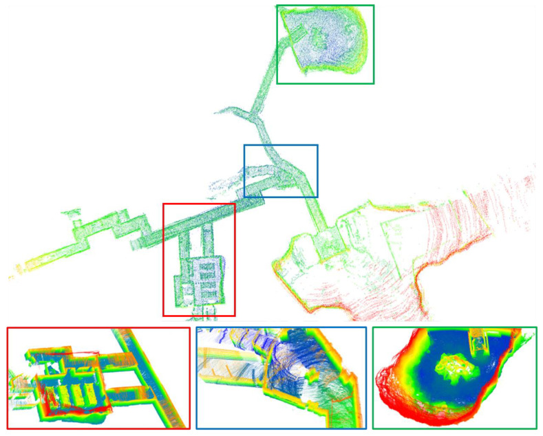
The demand for autonomous exploration and mapping of underground environments has significantly increased in recent years. However, accurately localizing and mapping robots in subterranean settings presents notable challenges. This paper presents a tightly coupled LiDAR-Inertial odometry system that combines the NanoGICP point cloud registration method with IMU pre-integration using incremental smoothing and mapping. Specifically, a point cloud affected by dust particles is first filtered out and separated into ground and non-ground point clouds (for ground vehicles). To maintain accuracy in environments with spatial variations, an adaptive voxel filter is employed, which reduces computation time while preserving accuracy. The estimated motion derived from IMU pre-integration is utilized to correct point cloud distortion and provide an initial estimation for LiDAR odometry. Subsequently, a scan-to-map point cloud registration is executed using NanoGICP to obtain a more refined pose estimation. The resulting LiDAR odometry is then employed to estimate the bias of the IMU. We comprehensively evaluated our system on established subterranean datasets. These datasets were collected by two separate teams using different platforms during the DARPA Subterranean (SubT) Challenge. The experimental results demonstrate that our system achieved performance enhancements as high as 50-60% in terms of root mean square error (RMSE).

摘要

近年来,对地下环境自主探索和测绘的需求显著增加。然而,在地下环境中精确定位和测绘机器人面临着显著挑战。本文提出了一种紧密耦合的激光雷达-惯性里程计系统,该系统将NanoGICP点云配准方法与使用增量平滑和映射的惯性测量单元(IMU)预积分相结合。具体而言,首先滤除受灰尘颗粒影响的点云,并将其分离为地面和非地面点云(用于地面车辆)。为了在空间变化的环境中保持精度,采用了自适应体素滤波器,该滤波器在保持精度的同时减少了计算时间。利用从IMU预积分得出的估计运动来校正点云畸变,并为激光雷达里程计提供初始估计。随后,使用NanoGICP执行扫描到地图的点云配准,以获得更精确的位姿估计。然后,将所得的激光雷达里程计用于估计IMU的偏差。我们在已建立的地下数据集上对我们的系统进行了全面评估。这些数据集是由两个独立的团队在DARPA地下(SubT)挑战赛期间使用不同平台收集的。实验结果表明,我们的系统在均方根误差(RMSE)方面实现了高达50%-60%的性能提升。

https://cdn.ncbi.nlm.nih.gov/pmc/blobs/4a5b/10422614/dac33f25d0a4/sensors-23-06834-g009.jpg
https://cdn.ncbi.nlm.nih.gov/pmc/blobs/4a5b/10422614/25afcb7a841e/sensors-23-06834-g001.jpg
https://cdn.ncbi.nlm.nih.gov/pmc/blobs/4a5b/10422614/c037d8c8e876/sensors-23-06834-g002.jpg
https://cdn.ncbi.nlm.nih.gov/pmc/blobs/4a5b/10422614/d561a6b37dec/sensors-23-06834-g003.jpg
https://cdn.ncbi.nlm.nih.gov/pmc/blobs/4a5b/10422614/81978b61ff18/sensors-23-06834-g004.jpg
https://cdn.ncbi.nlm.nih.gov/pmc/blobs/4a5b/10422614/46c3c1b3b809/sensors-23-06834-g005.jpg
https://cdn.ncbi.nlm.nih.gov/pmc/blobs/4a5b/10422614/93e8de1f8a4b/sensors-23-06834-g006.jpg
https://cdn.ncbi.nlm.nih.gov/pmc/blobs/4a5b/10422614/c61fb83a74cc/sensors-23-06834-g007.jpg
https://cdn.ncbi.nlm.nih.gov/pmc/blobs/4a5b/10422614/ea8f299ff66e/sensors-23-06834-g008.jpg
https://cdn.ncbi.nlm.nih.gov/pmc/blobs/4a5b/10422614/dac33f25d0a4/sensors-23-06834-g009.jpg

相似文献

1
Tightly Coupled LiDAR-Inertial Odometry and Mapping for Underground Environments.用于地下环境的紧密耦合激光雷达-惯性里程计与建图
Sensors (Basel). 2023 Jul 31;23(15):6834. doi: 10.3390/s23156834.
2
3D LiDAR Point Cloud Registration Based on IMU Preintegration in Coal Mine Roadways.基于 IMU 预积分的煤矿巷道 3D LiDAR 点云配准
Sensors (Basel). 2023 Mar 26;23(7):3473. doi: 10.3390/s23073473.
3
Robust Lidar-Inertial Odometry with Ground Condition Perception and Optimization Algorithm for UGV.基于地面状况感知和优化算法的 UGV 鲁棒激光雷达惯性里程计
Sensors (Basel). 2022 Sep 29;22(19):7424. doi: 10.3390/s22197424.
4
OMC-SLIO: Online Multiple Calibrations Spinning LiDAR Inertial Odometry.OMC-SLIO:在线多校准旋转式激光雷达惯性里程计。
Sensors (Basel). 2022 Dec 26;23(1):248. doi: 10.3390/s23010248.
5
LiDAR Inertial Odometry Based on Indexed Point and Delayed Removal Strategy in Highly Dynamic Environments.基于索引点和延迟移除策略的 LiDAR 惯性里程计在高度动态环境下的应用。
Sensors (Basel). 2023 May 30;23(11):5188. doi: 10.3390/s23115188.
6
Robust Localization of Industrial Park UGV and Prior Map Maintenance.工业园区无人地面车辆的稳健定位及先验地图维护
Sensors (Basel). 2023 Aug 6;23(15):6987. doi: 10.3390/s23156987.
7
LIO-CSI: LiDAR inertial odometry with loop closure combined with semantic information.LIO-CSI:结合语义信息的具有闭环检测功能的激光雷达惯性里程计。
PLoS One. 2021 Dec 8;16(12):e0261053. doi: 10.1371/journal.pone.0261053. eCollection 2021.
8
Optimized LOAM Using Ground Plane Constraints and SegMatch-Based Loop Detection.利用地平面约束和基于 SegMatch 的回环检测优化 LOAM。
Sensors (Basel). 2019 Dec 9;19(24):5419. doi: 10.3390/s19245419.
9
Marked-LIEO: Visual Marker-Aided LiDAR/IMU/Encoder Integrated Odometry.显著标记辅助激光雷达/惯性测量单元/编码器集成里程计
Sensors (Basel). 2022 Jun 23;22(13):4749. doi: 10.3390/s22134749.
10
VILO SLAM: Tightly Coupled Binocular Vision-Inertia SLAM Combined with LiDAR.VILO SLAM:紧耦合双目视觉惯性 SLAM 与激光雷达相结合。
Sensors (Basel). 2023 May 9;23(10):4588. doi: 10.3390/s23104588.

引用本文的文献

1
Sensor-Fusion Based Navigation for Autonomous Mobile Robot.基于传感器融合的自主移动机器人导航
Sensors (Basel). 2025 Feb 18;25(4):1248. doi: 10.3390/s25041248.
2
Kalman-Based Scene Flow Estimation for Point Cloud Densification and 3D Object Detection in Dynamic Scenes.基于卡尔曼滤波的动态场景点云致密化与三维目标检测的场景流估计
Sensors (Basel). 2024 Jan 31;24(3):916. doi: 10.3390/s24030916.

本文引用的文献

1
CERBERUS in the DARPA Subterranean Challenge.国防高级研究计划局地下挑战赛中的刻耳柏洛斯。
Sci Robot. 2022 May 25;7(66):eabp9742. doi: 10.1126/scirobotics.abp9742.