Ding Yibo, Wang Fengzuo, Lu Zehua, Sun Peng, Wei Renjuan, Zhou Li, Ao Tianqi
State Key Laboratory of Hydraulics and Mountain River Engineering & College of Water Resource and Hydropower, Sichuan University, Chengdu, 610065, China.
Yellow River Engineering Consulting Co., Ltd, Zhengzhou, 450003, China.
Sci Rep. 2024 Aug 26;14(1):19740. doi: 10.1038/s41598-024-70547-8.
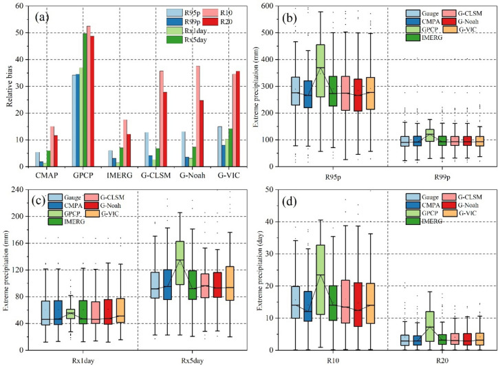
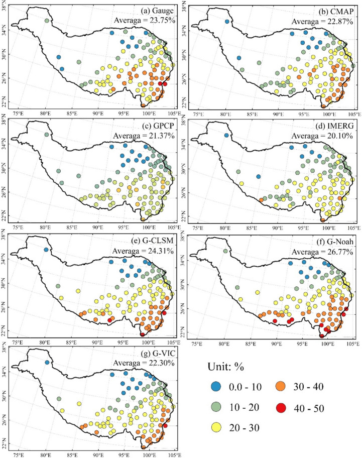
The Tibetan Plateau, often referred to as Asia's water tower, is a focal point for studying spatiotemporal changes in water resources amidst global warming. Precipitation is a crucial water resource for the Tibetan Plateau. Precipitation information holds significant importance in supporting research on the Tibetan Plateau. In this study, we estimate the performance and applicability of Climate Prediction Center Merged Analysis of Precipitation (CMAP), Integrated Multi-Satellite Retrievals for Global Precipitation Measurement (IMERG), Global Land Data Assimilation System (GLDAS), and Global Precipitation Climatology Project (GPCP) precipitation products for estimating precipitation and different disaster scenarios (including extreme precipitation, drought, and snow) across the Tibetan Plateau. Extreme precipitation and drought indexes are employed to describe extreme precipitation and drought conditions. We evaluated the performance of various precipitation products using daily precipitation time series from 2000 to 2014. Statistical metrics were used to estimate and compare the performances of different precipitation products. The results indicate that (1) Both CMAP and IMERG showed higher fitting degrees with gauge precipitation observations in daily precipitation. Probability of detection, False Alarm Ratio, and Critical Success Index values of CMAP and IMERG were approximately 0.42 to 0.72, 0.38 to 0.56, and 0.30 to 0.42, respectively. Different precipitation products presented higher daily average precipitation amount and frequency in southeastern Tibetan Plateau. (2) CMAP and GPCP precipitation products showed relatively great and poor performance, respectively, in predicting daily and monthly precipitation on the plateau. False alarms might have a notable impact on the accuracy of precipitation products. (3) Extreme precipitation amount could be better predicted by precipitation products. Extreme precipitation day could be badly predicted by precipitation products. Different precipitation products showed that the bias of drought estimation increased as the time scale increased. (4) GLDAS series products might have relatively better performance in simulating (main range of RMSE: 2.0-4.5) snowfall than rainfall and sleet in plateau. G-Noah demonstrated slightly better performance in simulating snowfall (main range of RMSE: 1.0-2.1) than rainfall (main range of RMSE: 2.0-3.8) and sleet (main range of RMSE: 1.5-3.8). This study's findings contribute to understanding the performance variations among different precipitation products and identifying potential factors contributing to biases within these products. Additionally, the study sheds light on disaster characteristics and warning systems specific to the Tibetan Plateau.
青藏高原常被称为亚洲水塔,是研究全球变暖背景下水资源时空变化的焦点。降水是青藏高原至关重要的水资源。降水信息对于支持青藏高原的研究具有重要意义。在本研究中,我们评估了气候预测中心合并降水分析(CMAP)、全球降水测量综合多卫星反演(IMERG)、全球陆地数据同化系统(GLDAS)和全球降水气候学计划(GPCP)降水产品在估算青藏高原降水及不同灾害情景(包括极端降水、干旱和降雪)方面的性能和适用性。采用极端降水和干旱指数来描述极端降水和干旱状况。我们利用2000年至2014年的日降水时间序列评估了各种降水产品的性能。使用统计指标来估计和比较不同降水产品的性能。结果表明:(1)CMAP和IMERG在日降水方面与雨量计降水观测的拟合度较高。CMAP和IMERG的探测概率、误报率和临界成功指数值分别约为0.42至0.72、0.38至0.56和0.30至0.42。不同降水产品在青藏高原东南部呈现出较高的日平均降水量和频率。(2)CMAP和GPCP降水产品在预测高原日降水和月降水方面分别表现出相对较好和较差的性能。误报可能对降水产品的准确性产生显著影响。(3)降水产品对极端降水量的预测效果较好。降水产品对极端降水日的预测效果较差。不同降水产品表明,干旱估计的偏差随时间尺度的增加而增大。(4)GLDAS系列产品在模拟高原降雪(均方根误差主要范围:2.0 - 4.5)方面可能比降雨和雨夹雪具有相对更好的性能。G - Noah在模拟降雪(均方根误差主要范围:1.0 - 2.1)方面比降雨(均方根误差主要范围:2.0 - 3.8)和雨夹雪(均方根误差主要范围:1.5 - 3.8)表现略好。本研究结果有助于理解不同降水产品之间的性能差异,并识别导致这些产品偏差的潜在因素。此外,该研究还揭示了青藏高原特有的灾害特征和预警系统。