• 文献检索
  • 文档翻译
  • 深度研究
  • 学术资讯
  • Suppr Zotero 插件Zotero 插件
  • 邀请有礼
  • 套餐&价格
  • 历史记录
应用&插件
Suppr Zotero 插件Zotero 插件浏览器插件Mac 客户端Windows 客户端微信小程序
定价
高级版会员购买积分包购买API积分包
服务
文献检索文档翻译深度研究API 文档MCP 服务
关于我们
关于 Suppr公司介绍联系我们用户协议隐私条款
关注我们

Suppr 超能文献

核心技术专利:CN118964589B侵权必究
粤ICP备2023148730 号-1Suppr @ 2026

文献检索

告别复杂PubMed语法,用中文像聊天一样搜索,搜遍4000万医学文献。AI智能推荐,让科研检索更轻松。

立即免费搜索

文件翻译

保留排版,准确专业,支持PDF/Word/PPT等文件格式,支持 12+语言互译。

免费翻译文档

深度研究

AI帮你快速写综述,25分钟生成高质量综述,智能提取关键信息,辅助科研写作。

立即免费体验

利用遥感和航空放射性数据对埃及中东部沙漠贾巴尔哈马达特地区进行矿产勘探与环境影响评估。

Mineral exploration and environmental impact assessment in the Jabal Hamadat Area, Central Eastern Desert, Egypt, using remote sensing and airborne radiometric data.

作者信息

Hegab Mahmoud Abd El-Rahman

机构信息

National Authority for Remote Sensing and Space Sciences (NARSS), Cairo, Egypt.

出版信息

Sci Rep. 2024 Sep 23;14(1):21986. doi: 10.1038/s41598-024-71387-2.

DOI:10.1038/s41598-024-71387-2
PMID:39313496
原文链接:https://pmc.ncbi.nlm.nih.gov/articles/PMC11420365/
Abstract

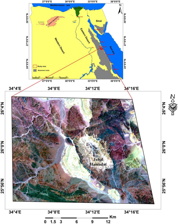
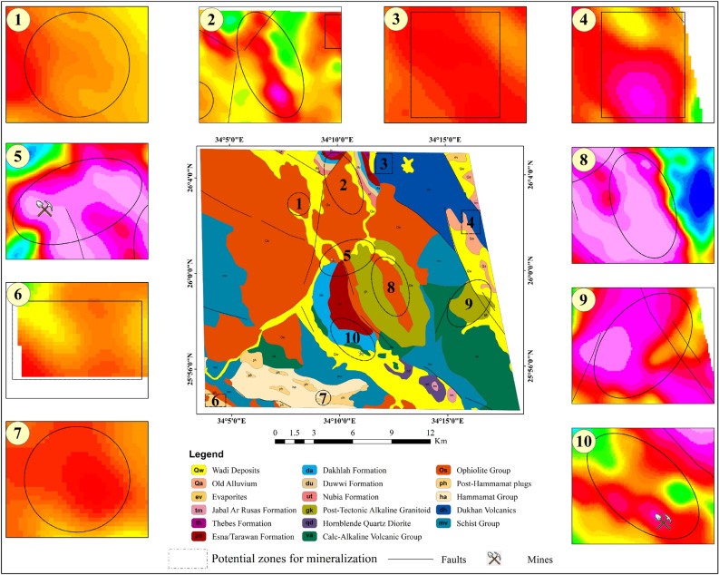
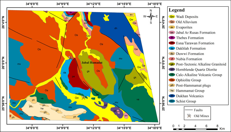
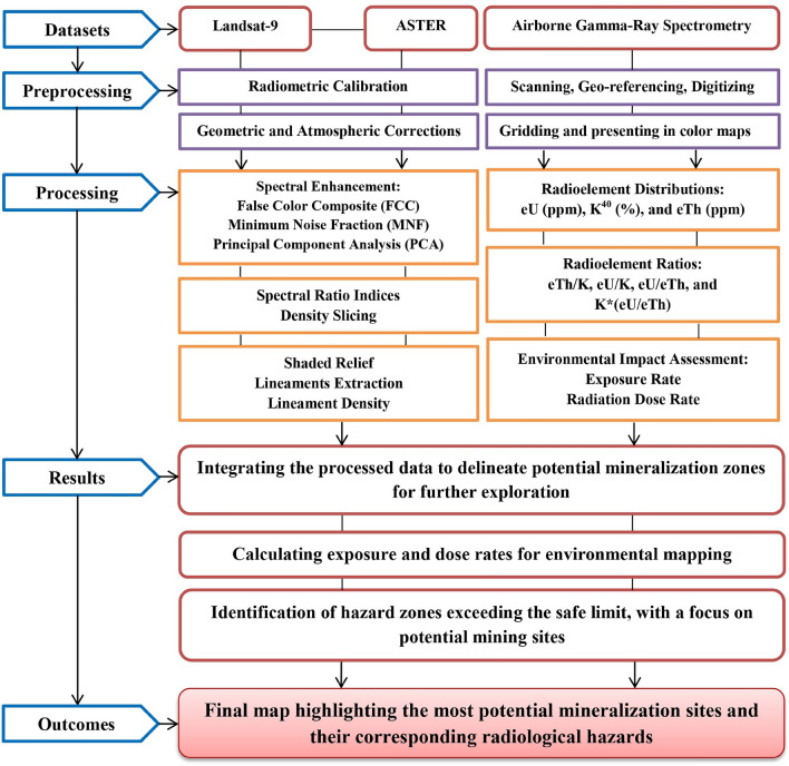
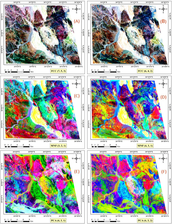
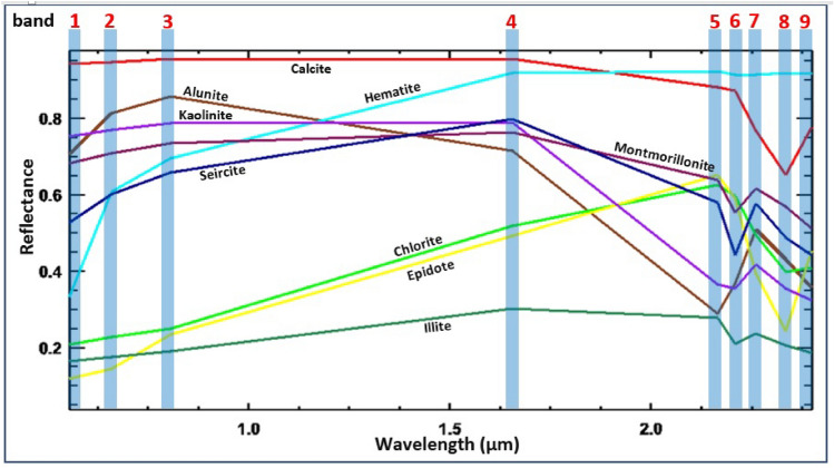
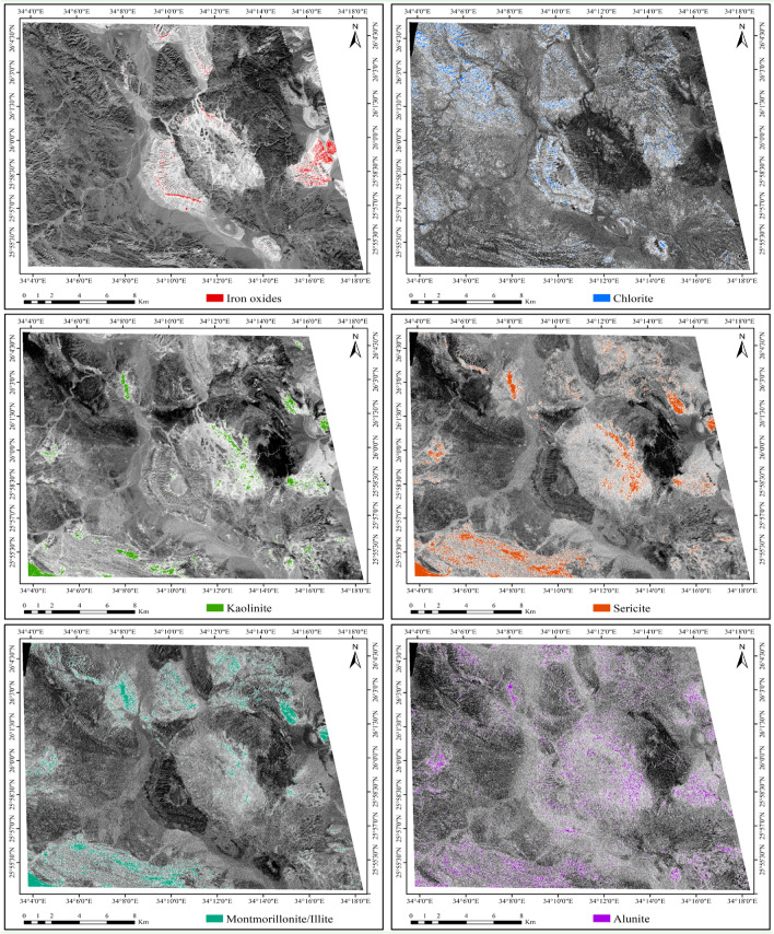
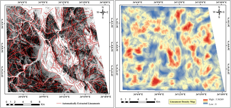
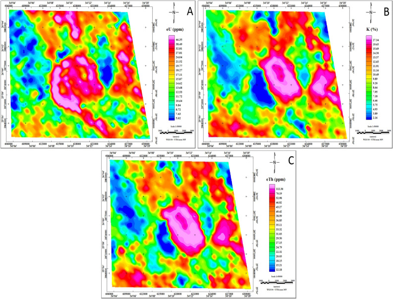
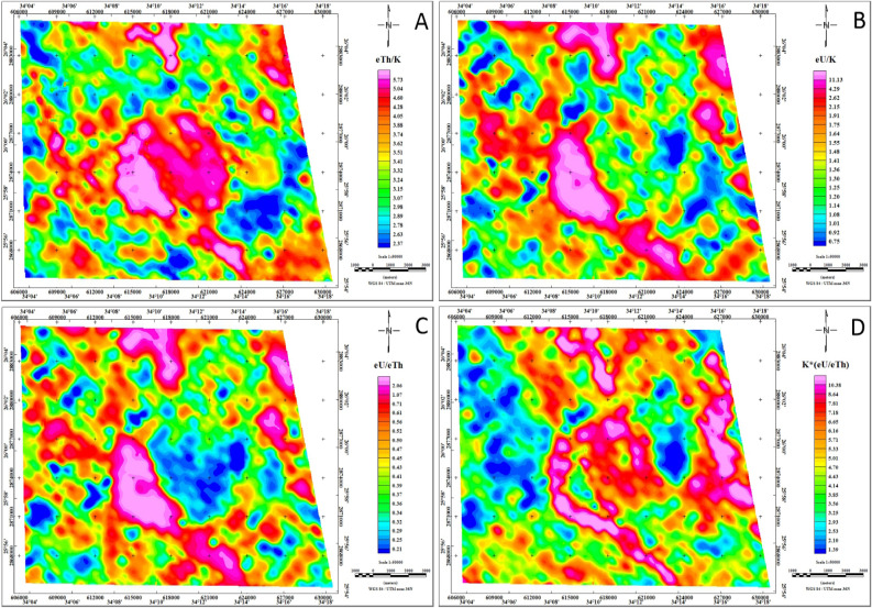
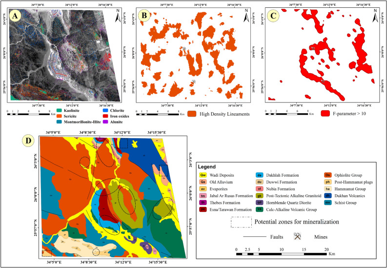
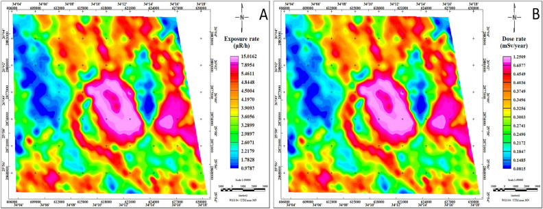
Mineral exploration is essential for economic growth, but it must be conducted with careful consideration of health and environmental impacts. This study focuses on mapping potential mineralization areas and evaluating environmental consequences in the Jabal Hamadat area. By integrating ASTER, Landsat-9 and airborne radiometric data, the study includes: (1) identification of alteration mineral indicators including iron oxides (gossanized zone), chlorite (propylitic zone), kaolinite, sericite, montmorillonite/illite (argillic zone), and alunite (advanced argillic zone) via the Band Ratio (BR) technique; (2) preparation of a lineament density map through an automated lineament extraction technique; and (3) identification of areas with elevated F-parameter values exceeding 10. Ten areas with high mineralization potential are delineated for further exploration. Additionally, the study assesses environmental radiation exposure, finding that certain areas exceed the safe radiation limit of 1.0 mSv/year. Peak radiation levels range from 0.75 to 1.25 mSv/year, with mining sites showing the highest readings at 1.25 mSv/year and 0.64 mSv/year. These findings highlight elevated radiological hazards, emphasizing the need for comprehensive monitoring and effective mitigation strategies to protect human health and minimize environmental impact. The methodology's success in this area indicates its potential applicability to other mining areas, contributing to enhanced safety and environmental protection.

摘要

矿产勘探对经济增长至关重要,但必须在仔细考虑对健康和环境的影响的情况下进行。本研究聚焦于绘制贾巴尔·哈马达特地区潜在矿化区域并评估环境后果。通过整合高级星载热辐射反射辐射计(ASTER)、陆地卫星9号和航空放射性数据,该研究包括:(1)通过波段比值(BR)技术识别蚀变矿物指标,包括氧化铁(铁帽化带)、绿泥石(青磐岩化带)、高岭石、绢云母、蒙脱石/伊利石(泥化带)和明矾石(高级泥化带);(2)通过自动线性构造提取技术编制线性构造密度图;(3)识别F参数值超过10的区域。划定了10个具有高矿化潜力的区域以供进一步勘探。此外,该研究评估了环境辐射暴露情况,发现某些区域超过了每年1.0毫希沃特的安全辐射限值。辐射峰值水平在每年0.75至1.25毫希沃特之间,矿场的读数最高,分别为每年1.25毫希沃特和0.64毫希沃特。这些发现凸显了较高的辐射危害,强调需要进行全面监测并采取有效的缓解策略,以保护人类健康并将环境影响降至最低。该方法在这一领域的成功表明其在其他矿区的潜在适用性,有助于加强安全和环境保护。

https://cdn.ncbi.nlm.nih.gov/pmc/blobs/5bc8/11420365/269ba8303465/41598_2024_71387_Fig13_HTML.jpg
https://cdn.ncbi.nlm.nih.gov/pmc/blobs/5bc8/11420365/b8e7760b58d8/41598_2024_71387_Fig1_HTML.jpg
https://cdn.ncbi.nlm.nih.gov/pmc/blobs/5bc8/11420365/31c7d00b71c7/41598_2024_71387_Fig2_HTML.jpg
https://cdn.ncbi.nlm.nih.gov/pmc/blobs/5bc8/11420365/43eccfd06b17/41598_2024_71387_Fig3_HTML.jpg
https://cdn.ncbi.nlm.nih.gov/pmc/blobs/5bc8/11420365/8dc70121a9f8/41598_2024_71387_Fig4_HTML.jpg
https://cdn.ncbi.nlm.nih.gov/pmc/blobs/5bc8/11420365/b8791037dee0/41598_2024_71387_Fig5_HTML.jpg
https://cdn.ncbi.nlm.nih.gov/pmc/blobs/5bc8/11420365/b239c220e03c/41598_2024_71387_Fig6_HTML.jpg
https://cdn.ncbi.nlm.nih.gov/pmc/blobs/5bc8/11420365/269b5827ec52/41598_2024_71387_Fig7_HTML.jpg
https://cdn.ncbi.nlm.nih.gov/pmc/blobs/5bc8/11420365/1cf630d1c5cd/41598_2024_71387_Fig8_HTML.jpg
https://cdn.ncbi.nlm.nih.gov/pmc/blobs/5bc8/11420365/ab6702c33c59/41598_2024_71387_Fig9_HTML.jpg
https://cdn.ncbi.nlm.nih.gov/pmc/blobs/5bc8/11420365/1392a5de6100/41598_2024_71387_Fig10_HTML.jpg
https://cdn.ncbi.nlm.nih.gov/pmc/blobs/5bc8/11420365/1610a214a66e/41598_2024_71387_Fig11_HTML.jpg
https://cdn.ncbi.nlm.nih.gov/pmc/blobs/5bc8/11420365/77652093ff78/41598_2024_71387_Fig12_HTML.jpg
https://cdn.ncbi.nlm.nih.gov/pmc/blobs/5bc8/11420365/269ba8303465/41598_2024_71387_Fig13_HTML.jpg

相似文献

1
Mineral exploration and environmental impact assessment in the Jabal Hamadat Area, Central Eastern Desert, Egypt, using remote sensing and airborne radiometric data.利用遥感和航空放射性数据对埃及中东部沙漠贾巴尔哈马达特地区进行矿产勘探与环境影响评估。
Sci Rep. 2024 Sep 23;14(1):21986. doi: 10.1038/s41598-024-71387-2.
2
Integrating remote sensing and geophysical data for mapping potential gold mineralization localities at Abu Marawat area, central Eastern Desert, Egypt.整合遥感和地球物理数据以绘制埃及东部沙漠中部阿布马拉瓦特地区潜在金矿化地点的地图。
Sci Rep. 2024 Aug 6;14(1):18273. doi: 10.1038/s41598-024-68921-7.
3
Towards better delineation of hydrothermal alterations via multi-sensor remote sensing and airborne geophysical data.通过多传感器遥感和航空地球物理数据实现更好的热液蚀变划分。
Sci Rep. 2023 May 6;13(1):7406. doi: 10.1038/s41598-023-34531-y.
4
A multi-disciplinary approach for uranium exploration using remote sensing and airborne gamma-ray spectrometry data in the Gebel Duwi area, Central Eastern Desert, Egypt.埃及中东部沙漠盖贝尔杜维地区利用遥感和航空伽马能谱数据进行铀矿勘探的多学科方法
Sci Rep. 2024 Aug 26;14(1):19739. doi: 10.1038/s41598-024-69147-3.
5
IDENTIFICATION OF AREAS OF HIGH POTENTIAL-BEARING MINERALIZATIONS, EASTERN DESERT OF EGYPT: INSIGHTS FROM AIRBORNE GAMMA-RAY SPECTROMETRIC DATA.埃及东部沙漠高潜力含矿矿化区的识别:来自航空伽马射线能谱数据的见解
Radiat Prot Dosimetry. 2023 Mar 17;199(4):294-311. doi: 10.1093/rpd/ncac270.
6
Lithological discrimination and mineralogical mapping using Landsat-8 OLI and ASTER remote sensing data: Igoudrane region, jbel saghro, Anti Atlas, Morocco.利用陆地卫星8号运营陆地成像仪(OLI)和先进星载热发射和反射辐射仪(ASTER)遥感数据进行岩性判别和矿物填图:摩洛哥阿特拉斯山脉南麓贾贝尔萨格罗山伊古德rane地区
Heliyon. 2023 Jun 21;9(7):e17363. doi: 10.1016/j.heliyon.2023.e17363. eCollection 2023 Jul.
7
Environmental impact assessement and determination of radiogenic heat production in the North Jabal Maghrabiyah area, Central Eastern Desert, Egypt.
Appl Radiat Isot. 2024 Sep;211:111398. doi: 10.1016/j.apradiso.2024.111398. Epub 2024 Jun 21.
8
Using of airborne gamma-ray spectrometric data to the exposure of potassic alteration -recognition of alteration relates to gold mineralization.利用航空伽马能谱数据进行钾化蚀变暴露的研究——蚀变与金矿化的关系识别。
Appl Radiat Isot. 2022 Dec;190:110511. doi: 10.1016/j.apradiso.2022.110511. Epub 2022 Oct 13.
9
Radiometric characteristics of some metallic ores and nonmetallic deposits: an example, Wadi Al-Allaqi, South Eastern Desert, Egypt.一些金属矿石和非金属矿床的辐射测量特征:以埃及东南部沙漠的瓦迪阿拉基为例。
Sci Rep. 2024 Jan 30;14(1):2443. doi: 10.1038/s41598-024-52912-9.
10
Geological controls of mineralization occurrences in the Egyptian Eastern Desert using advanced integration of remote sensing and magnetic data.利用遥感和磁数据的先进集成技术对埃及东部沙漠矿化点的地质控制因素
Sci Rep. 2024 Jul 19;14(1):16700. doi: 10.1038/s41598-024-66924-y.

引用本文的文献

1
Unveiling the subsurface geological structure of the centre region, cameroon, with aeromagnetic data analysis.利用航磁数据分析揭示喀麦隆中部地区的地下地质结构
Sci Rep. 2025 Sep 26;15(1):33296. doi: 10.1038/s41598-025-08077-0.
2
Gold exploration in the Gabal Abu Karahish area, Central Eastern Desert, Egypt: an integrated geological perspective.埃及中东部沙漠加巴尔·阿布·卡拉希什地区的金矿勘探:综合地质视角
Sci Rep. 2025 Jun 5;15(1):19730. doi: 10.1038/s41598-025-04496-1.

本文引用的文献

1
A multi-disciplinary approach for uranium exploration using remote sensing and airborne gamma-ray spectrometry data in the Gebel Duwi area, Central Eastern Desert, Egypt.埃及中东部沙漠盖贝尔杜维地区利用遥感和航空伽马能谱数据进行铀矿勘探的多学科方法
Sci Rep. 2024 Aug 26;14(1):19739. doi: 10.1038/s41598-024-69147-3.
2
Radiometric characteristics of some metallic ores and nonmetallic deposits: an example, Wadi Al-Allaqi, South Eastern Desert, Egypt.一些金属矿石和非金属矿床的辐射测量特征:以埃及东南部沙漠的瓦迪阿拉基为例。
Sci Rep. 2024 Jan 30;14(1):2443. doi: 10.1038/s41598-024-52912-9.
3
Towards better delineation of hydrothermal alterations via multi-sensor remote sensing and airborne geophysical data.
通过多传感器遥感和航空地球物理数据实现更好的热液蚀变划分。
Sci Rep. 2023 May 6;13(1):7406. doi: 10.1038/s41598-023-34531-y.
4
Natural radioactivity and radon exhalation rate of soil in southern Egypt.埃及南部土壤的天然放射性和氡析出率
Appl Radiat Isot. 2001 Dec;55(6):873-9. doi: 10.1016/s0969-8043(01)00123-3.