Kocur-Bera Katarzyna, Małek Anna
Institute of Geodesy and Civil Engineering, University of Warmia Mazury in Olsztyn, 10-719 Olsztyn, Poland.
Institute of Civil Engineering, Faculty of Civil and Transport Engineering, Poznan University of Technology, 60-965 Poznan, Poland.
Sensors (Basel). 2024 Dec 3;24(23):7736. doi: 10.3390/s24237736.
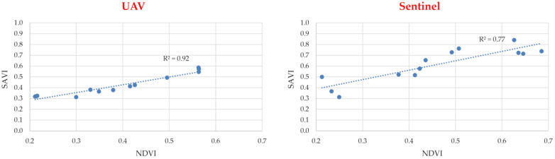
The values of vegetation indices can provide a new source of data for use in the estimation of land to be consolidated. The results of research work carried out so far indicate a significant advantage of low-volume imaging over satellite methods when it comes to calculating vegetation index values. This paper analyses multispectral images for the areas of selected croplands acquired via the Sentinel-2 satellite and an unmanned aerial vehicle (UAV) equipped with a multispectral camera. The research work consisted of evaluating (Normalised Difference Vegetation Index) and (Soil Adjusted Vegetation Index) values depending on the type of crop grown, the size of the cultivated area and the method of data acquisition. The data obtained were used to assess their potential use in the estimation of land to be consolidated. The effect of land consolidation is primarily to create more favourable living conditions and increase agricultural productivity. The results of the study showed that it would be preferable to use multispectral images acquired using UAVs rather than those from Sentinel satellites. This is due to the insufficient resolution of the satellite data, the correlation of and values at only a satisfactory level and the low accuracy of the data obtained for small registered plots of land.
植被指数的值可为土地整治估算提供新的数据来源。迄今为止开展的研究工作结果表明,在计算植被指数值方面,低空成像相对于卫星方法具有显著优势。本文分析了通过哨兵 - 2 卫星和配备多光谱相机的无人机获取的选定农田区域的多光谱图像。研究工作包括根据种植的作物类型、耕地面积大小和数据采集方法评估归一化差异植被指数(Normalised Difference Vegetation Index)和土壤调整植被指数(Soil Adjusted Vegetation Index)的值。所获得的数据用于评估它们在土地整治估算中的潜在用途。土地整治的效果主要是创造更有利的生活条件并提高农业生产力。研究结果表明,使用无人机获取的多光谱图像比哨兵卫星的图像更可取。这是由于卫星数据分辨率不足、归一化差异植被指数和土壤调整植被指数值的相关性仅处于令人满意的水平,以及小面积已登记地块所获数据的准确性较低。