Aparisi-Navarro Silvia, Moncho-Santonja Maria, Defez Beatriz, Candeias Carla, Rocha Fernando, Peris-Fajarnés Guillermo
Centro de Investigación en Tecnologias Gráficas. Universitat Politècnica de Valencia, Valencia, Spain.
GeoBioTec Research Unit, Geosciences Department, University of Aveiro, 3810-193, Aveiro, Portugal.
Heliyon. 2024 Dec 15;11(1):e41247. doi: 10.1016/j.heliyon.2024.e41247. eCollection 2025 Jan 15.
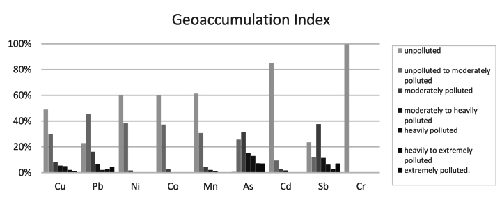
Soil contamination by heavy metals (HM) is a critical area of research. Traditional methods involving sample collection and lab analysis are effective but costly and time-consuming. This study explores whether geostatistical analysis with GIS and open data can provide a faster, more precise, and cost-effective alternative for HM contamination assessment without extensive sampling. Concentrations of nine HMs (Cu, Pb, Ni, Co, Mn, As, Cd, Sb, Cr) were analysed from 498 soil samples collected in two mining areas in Portugal: the Panasqueira and Aljustrel mines. Corresponding data were extracted from the Lucas TOPSOIL 1 km raster maps. Several contamination indices, Contamination Factor (Cf), Modified Contamination Degree (mCd), Geoaccumulation Index (Igeo), Nemerow Pollution Index (Pn), Potential Ecological Risk Index (PERI), and Pollution Load Index (PLI) were calculated for both datasets. A confusion matrix was used to evaluate the percentage of correct classifications, while a concordance analysis assessed the alignment of accurately classified points between the two data sources. In the soil samples, very high contamination levels for As were observed in 42% of the samples, according to the Cf, with high levels for Sb found in approximately 30% of the samples. The mCd revealed that approximately 11% of soil samples exhibited very high levels of contamination, while the Pn indicated that 78.9% of the soil samples fell within the seriously polluted domain. Similar contamination trends were observed for the other indices. In contrast, the results for the LUCAS points showed significant discrepancies. No high contamination levels were found for any metal. The misclassification rates for mCd, Pn, PERI, and PLI were 84.25%, 97.55%, 95%, and 82%, respectively, when compared to the field data. This study concludes that while open data raster maps offer rapid overviews, they fall short of providing the detailed precision required for reliable contamination assessments. The significant misclassification rates observed highlight the limitations of relying solely on these tools for critical environmental decisions. Consequently, traditional sampling and laboratory analysis remain indispensable for accurate risk assessments of HM contamination, ensuring a more reliable foundation for decision-making and environmental management.
重金属对土壤的污染是一个关键的研究领域。传统的方法包括样本采集和实验室分析,虽然有效,但成本高且耗时。本研究探讨了利用地理统计分析结合地理信息系统(GIS)和公开数据,能否在不进行大量采样的情况下,为重金属污染评估提供一种更快、更精确且更具成本效益的替代方法。对葡萄牙两个矿区(帕纳谢拉矿和阿尔朱斯特雷尔矿)采集的498个土壤样本中的9种重金属(铜、铅、镍、钴、锰、砷、镉、锑、铬)的浓度进行了分析。相应的数据从卢卡斯表层土壤1公里栅格地图中提取。针对这两个数据集计算了几个污染指数,即污染因子(Cf)、修正污染程度(mCd)、地累积指数(Igeo)、内梅罗污染指数(Pn)、潜在生态风险指数(PERI)和污染负荷指数(PLI)。使用混淆矩阵评估正确分类的百分比,同时通过一致性分析评估两个数据源之间准确分类点的一致性。在土壤样本中,根据污染因子,42%的样本中砷的污染水平非常高,约30%的样本中锑的含量较高。修正污染程度显示,约11%的土壤样本呈现出非常高的污染水平,而内梅罗污染指数表明78.9%的土壤样本处于严重污染范围。其他指数也观察到类似的污染趋势。相比之下,卢卡斯点的结果显示出显著差异。未发现任何金属有高污染水平。与实地数据相比,修正污染程度、内梅罗污染指数、潜在生态风险指数和污染负荷指数的误分类率分别为84.25%、97.55%、95%和82%。本研究得出结论,虽然公开数据栅格地图能提供快速概览,但它们缺乏可靠污染评估所需的详细精度。观察到的显著误分类率凸显了仅依靠这些工具做出关键环境决策的局限性。因此,传统的采样和实验室分析对于准确评估重金属污染风险仍然不可或缺,为决策和环境管理提供了更可靠的基础。