Bernier Eveline, Gosselin Pierre, Badard Thierry, Bédard Yvan
Center for Research in Geomatics (CRG), Université Laval, Québec, Canada.
Int J Health Geogr. 2009 Apr 3;8:18. doi: 10.1186/1476-072X-8-18.
Climate change has a significant impact on population health. Population vulnerabilities depend on several determinants of different types, including biological, psychological, environmental, social and economic ones. Surveillance of climate-related health vulnerabilities must take into account these different factors, their interdependence, as well as their inherent spatial and temporal aspects on several scales, for informed analyses. Currently used technology includes commercial off-the-shelf Geographic Information Systems (GIS) and Database Management Systems with spatial extensions. It has been widely recognized that such OLTP (On-Line Transaction Processing) systems were not designed to support complex, multi-temporal and multi-scale analysis as required above. On-Line Analytical Processing (OLAP) is central to the field known as BI (Business Intelligence), a key field for such decision-support systems. In the last few years, we have seen a few projects that combine OLAP and GIS to improve spatio-temporal analysis and geographic knowledge discovery. This has given rise to SOLAP (Spatial OLAP) and a new research area. This paper presents how SOLAP and climate-related health vulnerability data were investigated and combined to facilitate surveillance.
Based on recent spatial decision-support technologies, this paper presents a spatio-temporal web-based application that goes beyond GIS applications with regard to speed, ease of use, and interactive analysis capabilities. It supports the multi-scale exploration and analysis of integrated socio-economic, health and environmental geospatial data over several periods. This project was meant to validate the potential of recent technologies to contribute to a better understanding of the interactions between public health and climate change, and to facilitate future decision-making by public health agencies and municipalities in Canada and elsewhere. The project also aimed at integrating an initial collection of geo-referenced multi-scale indicators that were identified by Canadian specialists and end-users as relevant for the surveillance of the public health impacts of climate change. This system was developed in a multidisciplinary context involving researchers, policy makers and practitioners, using BI and web-mapping concepts (more particularly SOLAP technologies), while exploring new solutions for frequent automatic updating of data and for providing contextual warnings for users (to minimize the risk of data misinterpretation). According to the project participants, the final system succeeds in facilitating surveillance activities in a way not achievable with today's GIS. Regarding the experiments on frequent automatic updating and contextual user warnings, the results obtained indicate that these are meaningful and achievable goals but they still require research and development for their successful implementation in the context of surveillance and multiple organizations.
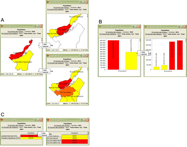
Surveillance of climate-related health vulnerabilities may be more efficiently supported using a combination of BI and GIS concepts, and more specifically, SOLAP technologies (in that it facilitates and accelerates multi-scale spatial and temporal analysis to a point where a user can maintain an uninterrupted train of thought by focussing on "what" she/he wants (not on "how" to get it) and always obtain instant answers, including to the most complex queries that take minutes or hours with OLTP systems (e.g., aggregated, temporal, comparative)). The developed system respects Newell's cognitive band of 10 seconds when performing knowledge discovery (exploring data, looking for hypotheses, validating models). The developed system provides new operators for easily and rapidly exploring multidimensional data at different levels of granularity, for different regions and epochs, and for visualizing the results in synchronized maps, tables and charts. It is naturally adapted to deal with multiscale indicators such as those used in the surveillance community, as confirmed by this project's end-users.
气候变化对人口健康有重大影响。人口脆弱性取决于多种不同类型的决定因素,包括生物、心理、环境、社会和经济因素。对与气候相关的健康脆弱性进行监测必须考虑这些不同因素、它们的相互依存关系,以及它们在多个尺度上固有的时空特征,以便进行明智的分析。目前使用的技术包括具有空间扩展功能的商用现成地理信息系统(GIS)和数据库管理系统。人们普遍认识到,此类联机事务处理(OLTP)系统并非为支持上述复杂的、多时间尺度和多空间尺度分析而设计。联机分析处理(OLAP)是商业智能(BI)领域的核心,而商业智能是此类决策支持系统的关键领域。在过去几年中,我们看到了一些将OLAP和GIS相结合以改进时空分析和地理知识发现的项目。这催生了空间联机分析处理(SOLAP)以及一个新的研究领域。本文介绍了如何对SOLAP和与气候相关的健康脆弱性数据进行研究和整合,以促进监测工作。
基于近期的空间决策支持技术,本文展示了一个基于网络的时空应用程序,该程序在速度、易用性和交互式分析能力方面超越了GIS应用程序。它支持对多个时期的综合社会经济、健康和环境地理空间数据进行多尺度探索和分析。该项目旨在验证近期技术有助于更好地理解公共卫生与气候变化之间相互作用的潜力,并促进加拿大及其他地区的公共卫生机构和市政当局未来的决策制定。该项目还旨在整合由加拿大专家和最终用户确定的与气候变化对公共卫生影响监测相关的地理参考多尺度指标的初始数据集。该系统是在一个涉及研究人员、政策制定者和从业者的多学科背景下开发的,采用了商业智能和网络地图概念(特别是SOLAP技术),同时探索了数据频繁自动更新和为用户提供上下文警告的新解决方案(以尽量减少数据误解的风险)。据项目参与者称,最终系统成功地以当今GIS无法实现的方式促进了监测活动。关于频繁自动更新和上下文用户警告的实验,所获得的结果表明这些是有意义且可实现的目标,但在监测和多个组织的背景下成功实施仍需要进行研发。
结合商业智能和GIS概念,更具体地说,结合SOLAP技术(因为它便于并加速多尺度空间和时间分析,使用户能够专注于“想要什么”(而非“如何获取”)并始终获得即时答案,包括对OLTP系统需要数分钟或数小时才能回答的最复杂查询(例如聚合、时间、比较查询),从而能够保持不间断的思路),可以更有效地支持对与气候相关的健康脆弱性进行监测。所开发的系统在进行知识发现(探索数据、寻找假设、验证模型)时符合纽厄尔提出的10秒认知带宽。所开发的系统提供了新的操作符,用于轻松快速地探索不同粒度级别、不同区域和时期的多维数据,并在同步地图、表格和图表中可视化结果。正如该项目的最终用户所证实的,它自然适用于处理监测领域中使用的多尺度指标。