Department of Oceanography, Texas A&M University, College Station, Texas, United States of America.
PLoS One. 2010 Dec 30;5(12):e15323. doi: 10.1371/journal.pone.0015323.
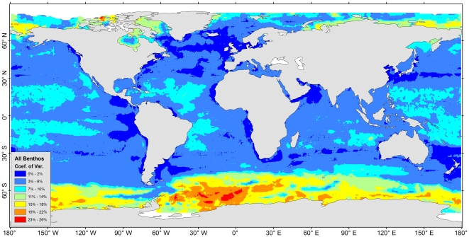
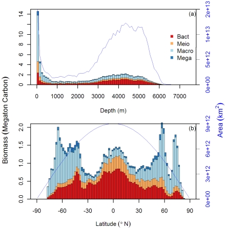
A comprehensive seafloor biomass and abundance database has been constructed from 24 oceanographic institutions worldwide within the Census of Marine Life (CoML) field projects. The machine-learning algorithm, Random Forests, was employed to model and predict seafloor standing stocks from surface primary production, water-column integrated and export particulate organic matter (POM), seafloor relief, and bottom water properties. The predictive models explain 63% to 88% of stock variance among the major size groups. Individual and composite maps of predicted global seafloor biomass and abundance are generated for bacteria, meiofauna, macrofauna, and megafauna (invertebrates and fishes). Patterns of benthic standing stocks were positive functions of surface primary production and delivery of the particulate organic carbon (POC) flux to the seafloor. At a regional scale, the census maps illustrate that integrated biomass is highest at the poles, on continental margins associated with coastal upwelling and with broad zones associated with equatorial divergence. Lowest values are consistently encountered on the central abyssal plains of major ocean basins The shift of biomass dominance groups with depth is shown to be affected by the decrease in average body size rather than abundance, presumably due to decrease in quantity and quality of food supply. This biomass census and associated maps are vital components of mechanistic deep-sea food web models and global carbon cycling, and as such provide fundamental information that can be incorporated into evidence-based management.
一个全面的海底生物量和丰度数据库已经由全球 24 个海洋学机构在海洋生物普查(CoML)的实地项目中构建。机器学习算法,随机森林,被用来模拟和预测海底存量从表面初级生产力,水柱综合和出口颗粒有机物质(POM),海底地形和底层水特性。预测模型解释了主要大小组之间 63%到 88%的库存变化。为细菌、小型动物、大型动物和巨型动物(无脊椎动物和鱼类)生成了预测全球海底生物量和丰度的个体和综合地图。底栖存量的模式是表面初级生产力和颗粒有机碳(POC)通量向海底输送的正函数。在区域尺度上,普查地图表明,综合生物量在极地最高,在与沿海上升流有关的大陆边缘最高,在与赤道离散有关的宽阔地带最高。在主要海洋盆地的中心深海平原上,始终存在最低值。随着深度的推移,生物量优势组的转移被认为是受平均体型减小而不是丰度的影响,这可能是由于食物供应的数量和质量下降所致。这个生物量普查和相关地图是深海食物网模型和全球碳循环的重要组成部分,因此提供了可以纳入循证管理的基本信息。