Departamento de Ecología y Recursos Naturales, Facultad de Ciencias, Universidad Nacional Autónoma de México, Mexico City, Mexico.
PLoS One. 2012;7(2):e30506. doi: 10.1371/journal.pone.0030506. Epub 2012 Feb 20.
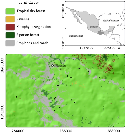
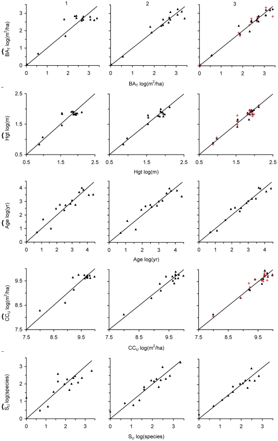
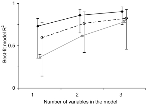
Biodiversity conservation and ecosystem-service provision will increasingly depend on the existence of secondary vegetation. Our success in achieving these goals will be determined by our ability to accurately estimate the structure and diversity of such communities at broad geographic scales. We examined whether the texture (the spatial variation of the image elements) of very high-resolution satellite imagery can be used for this purpose. In 14 fallows of different ages and one mature forest stand in a seasonally dry tropical forest landscape, we estimated basal area, canopy cover, stem density, species richness, Shannon index, Simpson index, and canopy height. The first six attributes were also estimated for a subset comprising the tallest plants. We calculated 40 texture variables based on the red and the near infrared bands, and EVI and NDVI, and selected the best-fit linear models describing each vegetation attribute based on them. Basal area (R(2) = 0.93), vegetation height and cover (0.89), species richness (0.87), and stand age (0.85) were the best-described attributes by two-variable models. Cross validation showed that these models had a high predictive power, and most estimated vegetation attributes were highly accurate. The success of this simple method (a single image was used and the models were linear and included very few variables) rests on the principle that image texture reflects the internal heterogeneity of successional vegetation at the proper scale. The vegetation attributes best predicted by texture are relevant in the face of two of the gravest threats to biosphere integrity: climate change and biodiversity loss. By providing reliable basal area and fallow-age estimates, image-texture analysis allows for the assessment of carbon sequestration and diversity loss rates. New and exciting research avenues open by simplifying the analysis of the extent and complexity of successional vegetation through the spatial variation of its spectral information.
生物多样性保护和生态系统服务的提供将越来越依赖于次生植被的存在。我们能否实现这些目标,将取决于我们能否在广泛的地理尺度上准确估计这些群落的结构和多样性。我们研究了高分辨率卫星图像的纹理(图像元素的空间变化)是否可用于此目的。在季节性干旱热带森林景观中,我们对 14 块不同年龄的休耕地和 1 块成熟林分进行了研究,对基部面积、冠层覆盖率、茎密度、物种丰富度、香农指数、辛普森指数和冠层高度进行了估计。前六个属性还针对包含最高植物的子集进行了估计。我们基于红波段和近红外波段以及 EVI 和 NDVI 计算了 40 个纹理变量,并根据这些变量选择了描述每个植被属性的最佳线性模型。基于两变量模型,基部面积(R²=0.93)、植被高度和覆盖(0.89)、物种丰富度(0.87)和林分年龄(0.85)的描述效果最好。交叉验证表明,这些模型具有较高的预测能力,并且大多数估计的植被属性具有较高的准确性。这种简单方法(仅使用一张图像,且模型为线性并包含很少的变量)之所以成功,是因为图像纹理反映了演替植被在适当尺度上的内在异质性。纹理最佳预测的植被属性与生物多样性完整性面临的两个最严重威胁(气候变化和生物多样性丧失)有关。通过提供可靠的基部面积和休耕年龄估计,图像纹理分析可以评估碳固存和多样性丧失率。通过简化对演替植被的范围和复杂性的分析,通过其光谱信息的空间变化,为新的令人兴奋的研究开辟了途径。