Department of Geology, Grand Valley State University, Allendale, MI 49401, USA.
Int J Health Geogr. 2013 Jan 18;12:3. doi: 10.1186/1476-072X-12-3.
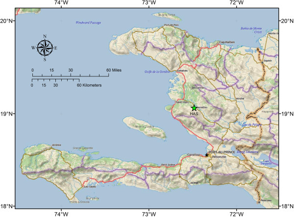
A remote sensing technique was developed which combines a Geographic Information System (GIS); Google Earth, and Microsoft Excel to identify home locations for a random sample of households in rural Haiti. The method was used to select homes for ethnographic and water quality research in a region of rural Haiti located within 9 km of a local hospital and source of health education in Deschapelles, Haiti. The technique does not require access to governmental records or ground based surveys to collect household location data and can be performed in a rapid, cost-effective manner.
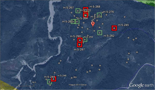
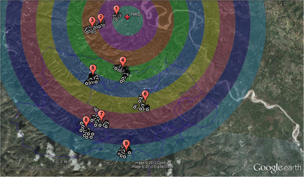
The random selection of households and the location of these households during field surveys were accomplished using GIS, Google Earth, Microsoft Excel, and handheld Garmin GPSmap 76CSx GPS units. Homes were identified and mapped in Google Earth, exported to ArcMap 10.0, and a random list of homes was generated using Microsoft Excel which was then loaded onto handheld GPS units for field location. The development and use of a remote sensing method was essential to the selection and location of random households.
A total of 537 homes initially were mapped and a randomized subset of 96 was identified as potential survey locations. Over 96% of the homes mapped using Google Earth imagery were correctly identified as occupied dwellings. Only 3.6% of the occupants of mapped homes visited declined to be interviewed. 16.4% of the homes visited were not occupied at the time of the visit due to work away from the home or market days. A total of 55 households were located using this method during the 10 days of fieldwork in May and June of 2012.
The method used to generate and field locate random homes for surveys and water sampling was an effective means of selecting random households in a rural environment lacking geolocation infrastructure. The success rate for locating households using a handheld GPS was excellent and only rarely was local knowledge required to identify and locate households. This method provides an important technique that can be applied to other developing countries where a randomized study design is needed but infrastructure is lacking to implement more traditional participant selection methods.
开发了一种遥感技术,该技术将地理信息系统(GIS);谷歌地球和微软 Excel 结合在一起,以确定海地农村随机抽取的家庭的家庭住址。该方法用于在海地农村地区的一个区域选择家庭进行民族志和水质研究,该地区距离海地的 Deschapelles 当地医院和健康教育源 9 公里以内。该技术不需要访问政府记录或地面调查来收集家庭住址数据,并且可以快速,经济高效地执行。
使用 GIS、谷歌地球、微软 Excel 和手持 Garmin GPSmap 76CSx GPS 设备来完成家庭的随机选择和实地调查中的位置。在谷歌地球上识别和绘制房屋,将其导出到 ArcMap 10.0,并使用 Microsoft Excel 生成一个随机的房屋列表,然后将其加载到手持式 GPS 设备上以进行现场定位。遥感方法的开发和使用对于随机家庭的选择和定位至关重要。
最初共绘制了 537 个房屋,并确定了 96 个随机子集作为潜在的调查地点。使用谷歌地球图像绘制的房屋中有超过 96%被正确识别为有人居住的住所。只有 3.6%的被绘制房屋的居民拒绝接受采访。在访问期间,由于离家工作或市场日,共有 16.4%的房屋无人居住。在 2012 年 5 月和 6 月的 10 天实地工作中,共使用此方法找到了 55 个家庭。
用于生成和现场定位随机家庭进行调查和水样采集的方法是在缺乏地理位置基础设施的农村环境中选择随机家庭的有效方法。使用手持 GPS 定位家庭的成功率非常高,很少需要当地知识来识别和定位家庭。该方法提供了一种重要的技术,可应用于其他发展中国家,这些国家需要随机研究设计,但缺乏实施更传统的参与者选择方法的基础设施。