Thanapongtharm Weerapong, Van Boeckel Thomas P, Biradar Chandrashekhar, Xiao Xiang-Ming, Gilbert Marius
Geospat Health. 2013 Nov;8(1):193-201. doi: 10.4081/gh.2013.66.
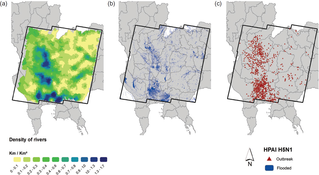
Thailand experienced several epidemic waves of the highly pathogenic avian influenza (HPAI) H5N1 between 2004 and 2005. This study investigated the role of water in the landscape, which has not been previously assessed because of a lack of high-resolution information on the distribution of flooded land at the time of the epidemic. Nine Landsat 7 - Enhanced Thematic Mapper Plus scenes covering 174,610 km(2) were processed using k-means unsupervised classification to map the distribution of flooded areas as well as permanent lakes and reservoirs at the time of the main epidemic HPAI H5N1 wave of October 2004. These variables, together with other factors previously identified as significantly associated with risk, were entered into an autologistic regression model in order to quantify the gain in risk explanation over previously published models. We found that, in addition to other factors previously identified as associated with risk, the proportion of land covered by flooding along with expansion of rivers and streams, derived from an existing, sub-district level (administrative level no. 3) geographical information system database, was a highly significant risk factor in this 2004 HPAI epidemic. These results suggest that water-borne transmission could have partly contributed to the spread of HPAI H5N1 during the epidemic. Future work stemming from these results should involve studies where the actual distribution of small canals, rivers, ponds, rice paddy fields and farms are mapped and tested against farm-level data with respect to HPAI H5N1.
2004年至2005年间,泰国经历了几波高致病性禽流感(HPAI)H5N1疫情。本研究调查了景观中水体的作用,由于在疫情发生时缺乏关于洪泛区分布的高分辨率信息,此前尚未对此进行评估。使用k均值无监督分类法处理了覆盖面积达174,610平方公里的9景陆地卫星7号增强型专题绘图仪Plus影像,以绘制2004年10月HPAI H5N1主要疫情波期间的洪泛区以及永久性湖泊和水库的分布。这些变量,连同其他先前确定与风险显著相关的因素,被纳入自逻辑回归模型,以量化相对于先前发表的模型在风险解释方面的增益。我们发现,除了先前确定与风险相关的其他因素外,从现有的分区级(行政三级)地理信息系统数据库得出的洪泛区覆盖比例以及河流和溪流的扩张,是2004年HPAI疫情中的一个高度显著的风险因素。这些结果表明,水媒传播可能在一定程度上促成了疫情期间HPAI H5N1的传播。基于这些结果的未来工作应包括绘制小运河、河流、池塘、稻田和农场的实际分布,并根据农场层面的HPAI H5N1数据进行测试的研究。