The Environment Institute and School of Earth and Environmental Sciences, The University of Adelaide Adelaide, South Australia, 5005, Australia.
Barbara Hardy Institute, University of South Australia GPO Box 2471, Adelaide, South Australia, 5001, Australia.
Ecol Evol. 2014 Jun;4(11):2103-14. doi: 10.1002/ece3.1094. Epub 2014 Apr 28.
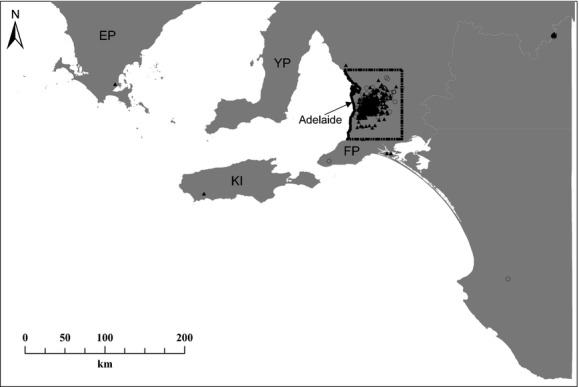
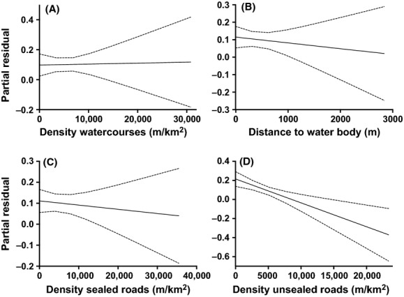
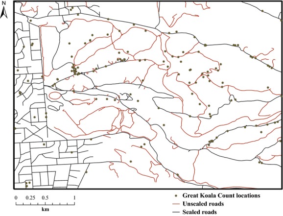
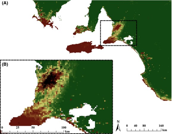
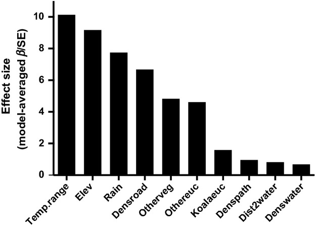
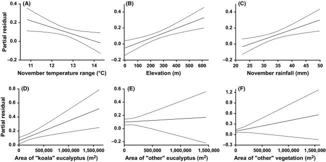
The koala (Phascolarctos cinereus) occurs in the eucalypt forests of eastern and southern Australia and is currently threatened by habitat fragmentation, climate change, sexually transmitted diseases, and low genetic variability throughout most of its range. Using data collected during the Great Koala Count (a 1-day citizen science project in the state of South Australia), we developed generalized linear mixed-effects models to predict habitat suitability across South Australia accounting for potential errors associated with the dataset. We derived spatial environmental predictors for vegetation (based on dominant species of Eucalyptus or other vegetation), topographic water features, rain, elevation, and temperature range. We also included predictors accounting for human disturbance based on transport infrastructure (sealed and unsealed roads). We generated random pseudo-absences to account for the high prevalence bias typical of citizen-collected data. We accounted for biased sampling effort along sealed and unsealed roads by including an offset for distance to transport infrastructures. The model with the highest statistical support (wAIC c ∼ 1) included all variables except rain, which was highly correlated with elevation. The same model also explained the highest deviance (61.6%), resulted in high R (2)(m) (76.4) and R (2)(c) (81.0), and had a good performance according to Cohen's κ (0.46). Cross-validation error was low (∼ 0.1). Temperature range, elevation, and rain were the best predictors of koala occurrence. Our models predict high habitat suitability in Kangaroo Island, along the Mount Lofty Ranges, and at the tips of the Eyre, Yorke and Fleurieu Peninsulas. In the highest-density region (5576 km(2)) of the Adelaide-Mount Lofty Ranges, a density-suitability relationship predicts a population of 113,704 (95% confidence interval: 27,685-199,723; average density = 5.0-35.8 km(-2)). We demonstrate the power of citizen science data for predicting species' distributions provided that the statistical approaches applied account for some uncertainties and potential biases. A future improvement to citizen science surveys to provide better data on search effort is that smartphone apps could be activated at the start of the search. The results of our models provide preliminary ranges of habitat suitability and population size for a species for which previous data have been difficult or impossible to gather otherwise.
树袋熊(Phascolarctos cinereus)出现在澳大利亚东部和南部的桉树森林中,目前正受到栖息地碎片化、气候变化、性传播疾病和遗传变异性低的威胁。利用在南澳大利亚州进行的大考拉计数(一项为期一天的公民科学项目)期间收集的数据,我们开发了广义线性混合效应模型,以预测南澳大利亚州的栖息地适宜性,同时考虑到与数据集相关的潜在误差。我们从植被(基于优势桉树或其他植被物种)、地形水特征、降雨、海拔和温度范围中得出空间环境预测因子。我们还包括了基于交通基础设施(密封和未密封道路)的人为干扰预测因子。我们生成了随机伪缺失值,以弥补公民收集数据中普遍存在的高偏倚偏差。我们通过包含到交通基础设施的距离偏移量来解释偏倚采样沿密封和未密封道路的努力。具有最高统计支持(wAIC c∼1)的模型包括除了与海拔高度高度相关的降雨之外的所有变量。同样的模型也解释了最高的偏差(61.6%),产生了高 R 2(m)(76.4)和 R 2(c)(81.0),根据 Cohen 的 κ(0.46),表现良好。交叉验证误差较低(约 0.1)。温度范围、海拔和降雨是考拉出现的最佳预测因子。我们的模型预测袋鼠岛、洛夫蒂山脉和艾尔、约克和弗勒里厄半岛的栖息地适宜性较高。在阿德莱德-洛夫蒂山脉的最高密度区域(5576 平方公里),密度适宜性关系预测人口为 113704(95%置信区间:27685-199723;平均密度= 5.0-35.8 公里(-2))。我们展示了公民科学数据对于预测物种分布的强大功能,前提是应用的统计方法考虑到了一些不确定性和潜在的偏差。公民科学调查的一个未来改进是,在搜索开始时可以激活智能手机应用程序,以提供更好的搜索努力数据。我们模型的结果为以前难以或不可能收集数据的物种提供了栖息地适宜性和种群规模的初步范围。