• 文献检索
  • 文档翻译
  • 深度研究
  • 学术资讯
  • Suppr Zotero 插件Zotero 插件
  • 邀请有礼
  • 套餐&价格
  • 历史记录
应用&插件
Suppr Zotero 插件Zotero 插件浏览器插件Mac 客户端Windows 客户端微信小程序
定价
高级版会员购买积分包购买API积分包
服务
文献检索文档翻译深度研究API 文档MCP 服务
关于我们
关于 Suppr公司介绍联系我们用户协议隐私条款
关注我们

Suppr 超能文献

核心技术专利:CN118964589B侵权必究
粤ICP备2023148730 号-1Suppr @ 2026

文献检索

告别复杂PubMed语法,用中文像聊天一样搜索,搜遍4000万医学文献。AI智能推荐,让科研检索更轻松。

立即免费搜索

文件翻译

保留排版,准确专业,支持PDF/Word/PPT等文件格式,支持 12+语言互译。

免费翻译文档

深度研究

AI帮你快速写综述,25分钟生成高质量综述,智能提取关键信息,辅助科研写作。

立即免费体验

三峡水库上游地区驱动SWAT模型的网格化降水数据评估

Evaluation of gridded precipitation data for driving SWAT model in area upstream of Three Gorges Reservoir.

作者信息

Yang Yan, Wang Guoqiang, Wang Lijing, Yu Jingshan, Xu Zongxue

机构信息

College of Water Sciences, Beijing Normal University, Beijing 100875, China; United Graduate School of Agricultural Science, Gifu University, 1-1 Yanagido, Gifu, 501-1193, Japan.

College of Water Sciences, Beijing Normal University, Beijing 100875, China.

出版信息

PLoS One. 2014 Nov 19;9(11):e112725. doi: 10.1371/journal.pone.0112725. eCollection 2014.

DOI:10.1371/journal.pone.0112725
PMID:25409467
原文链接:https://pmc.ncbi.nlm.nih.gov/articles/PMC4237342/
Abstract

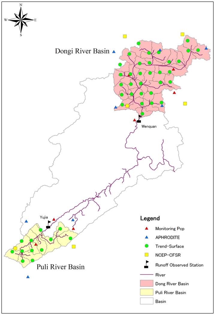
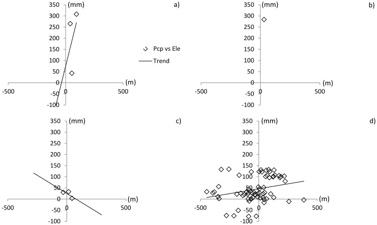
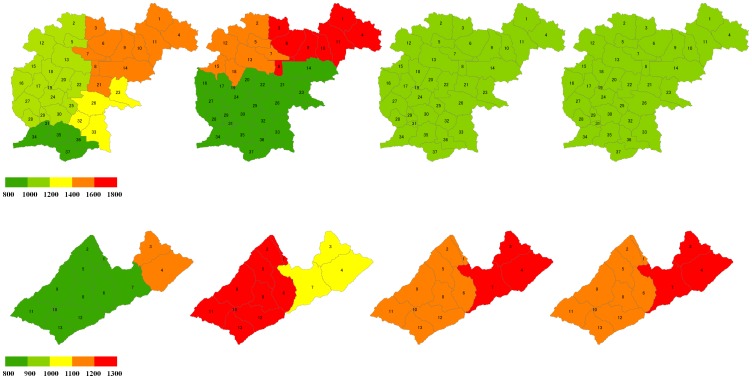
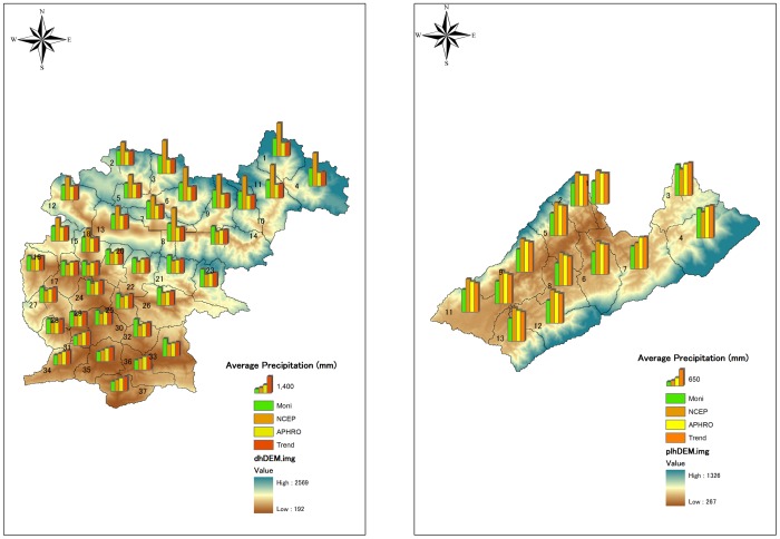
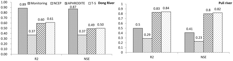
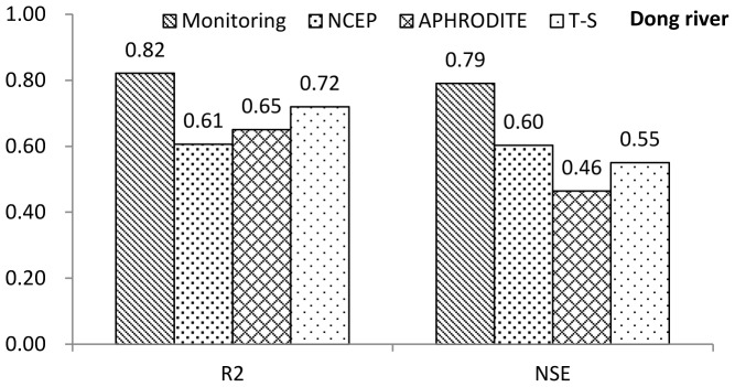
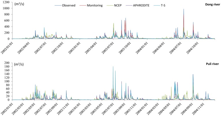
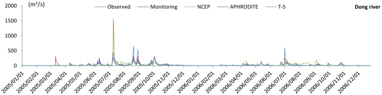
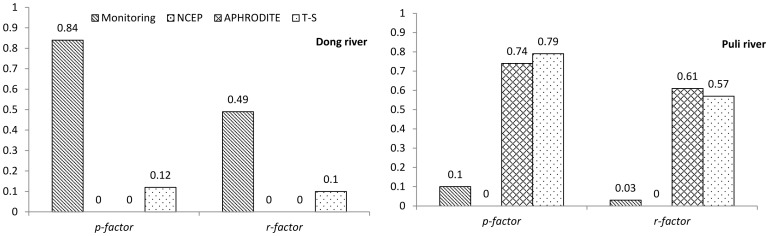
Gridded precipitation data are becoming an important source for driving hydrologic models to achieve stable and valid simulation results in different regions. Thus, evaluating different sources of precipitation data is important for improving the applicability of gridded data. In this study, we used three gridded rainfall datasets: 1) National Centers for Environmental Prediction-Climate Forecast System Reanalysis (NCEP-CFSR); 2) Asian Precipitation-Highly-Resolved Observational Data Integration Towards Evaluation (APHRODITE); and 3) China trend-surface reanalysis (trend surface) data. These are compared with monitoring precipitation data for driving the Soil and Water Assessment Tool in two basins upstream of Three Gorges Reservoir (TGR) in China. The results of one test basin with significant topographic influence indicates that all the gridded data have poor abilities in reproducing hydrologic processes with the topographic influence on precipitation quantity and distribution. However, in a relatively flat test basin, the APHRODITE and trend surface data can give stable and desirable results. The results of this study suggest that precipitation data for future applications should be considered comprehensively in the TGR area, including the influence of data density and topography.

摘要

网格化降水数据正成为驱动水文模型以在不同区域获得稳定且有效模拟结果的重要数据源。因此,评估不同来源的降水数据对于提高网格化数据的适用性至关重要。在本研究中,我们使用了三个网格化降雨数据集:1)美国国家环境预测中心气候预报系统再分析(NCEP - CFSR);2)亚洲降水——用于评估的高分辨率观测数据集成(APHRODITE);以及3)中国趋势面再分析(趋势面)数据。将这些数据与中国三峡水库(TGR)上游两个流域驱动土壤与水评估工具的监测降水数据进行比较。一个受地形影响显著的测试流域的结果表明,所有网格化数据在再现受地形影响的降水量和分布的水文过程方面能力较差。然而,在一个相对平坦的测试流域中,APHRODITE和趋势面数据能够给出稳定且理想的结果。本研究结果表明,未来在三峡库区应用降水数据时应综合考虑,包括数据密度和地形的影响。

https://cdn.ncbi.nlm.nih.gov/pmc/blobs/5eed/4237342/b4ae02a795c3/pone.0112725.g010.jpg
https://cdn.ncbi.nlm.nih.gov/pmc/blobs/5eed/4237342/dff26b568bda/pone.0112725.g001.jpg
https://cdn.ncbi.nlm.nih.gov/pmc/blobs/5eed/4237342/582c05d728ff/pone.0112725.g002.jpg
https://cdn.ncbi.nlm.nih.gov/pmc/blobs/5eed/4237342/8cf20843befc/pone.0112725.g003.jpg
https://cdn.ncbi.nlm.nih.gov/pmc/blobs/5eed/4237342/f432713a47f0/pone.0112725.g004.jpg
https://cdn.ncbi.nlm.nih.gov/pmc/blobs/5eed/4237342/f3f7d9378b1d/pone.0112725.g005.jpg
https://cdn.ncbi.nlm.nih.gov/pmc/blobs/5eed/4237342/5fc5ee9d3d90/pone.0112725.g006.jpg
https://cdn.ncbi.nlm.nih.gov/pmc/blobs/5eed/4237342/cb92eef5ab17/pone.0112725.g007.jpg
https://cdn.ncbi.nlm.nih.gov/pmc/blobs/5eed/4237342/a441f3e0a33a/pone.0112725.g008.jpg
https://cdn.ncbi.nlm.nih.gov/pmc/blobs/5eed/4237342/5df350d11bbd/pone.0112725.g009.jpg
https://cdn.ncbi.nlm.nih.gov/pmc/blobs/5eed/4237342/b4ae02a795c3/pone.0112725.g010.jpg

相似文献

1
Evaluation of gridded precipitation data for driving SWAT model in area upstream of Three Gorges Reservoir.三峡水库上游地区驱动SWAT模型的网格化降水数据评估
PLoS One. 2014 Nov 19;9(11):e112725. doi: 10.1371/journal.pone.0112725. eCollection 2014.
2
A review of alternative climate products for SWAT modelling: Sources, assessment and future directions.SWAT 模型中替代气候产品的研究综述:来源、评估和未来方向。
Sci Total Environ. 2021 Nov 15;795:148915. doi: 10.1016/j.scitotenv.2021.148915. Epub 2021 Jul 8.
3
Comparison of gridded precipitation datasets for rainfall-runoff and inundation modeling in the Mekong River Basin.比较湄公河流域降雨径流和洪水淹没建模的网格化降水数据集。
PLoS One. 2020 Jan 8;15(1):e0226814. doi: 10.1371/journal.pone.0226814. eCollection 2020.
4
Impact of land use changes on water quality in headwaters of the Three Gorges Reservoir.土地利用变化对三峡水库上游水质的影响
Environ Sci Pollut Res Int. 2016 Jun;23(12):11448-60. doi: 10.1007/s11356-015-5922-4. Epub 2015 Dec 19.
5
Study of uncertainty of satellite and reanalysis precipitation products and their impact on hydrological simulation.卫星和再分析降水产品不确定性研究及其对水文模拟的影响。
Environ Sci Pollut Res Int. 2021 Nov;28(43):60935-60953. doi: 10.1007/s11356-021-14847-w. Epub 2021 Jun 24.
6
Modelling Hydrologic Processes in the Mekong River Basin Using a Distributed Model Driven by Satellite Precipitation and Rain Gauge Observations.利用卫星降水和雨量计观测驱动的分布式模型对湄公河流域水文过程进行建模
PLoS One. 2016 Mar 24;11(3):e0152229. doi: 10.1371/journal.pone.0152229. eCollection 2016.
7
Multi-model driven by diverse precipitation datasets increases confidence in identifying dominant factors for runoff change in a subbasin of the Qaidam Basin of China.多模式驱动的多种降水数据集提高了确定中国柴达木盆地子流域径流量变化主导因素的信心。
Sci Total Environ. 2022 Jan 1;802:149831. doi: 10.1016/j.scitotenv.2021.149831. Epub 2021 Aug 22.
8
Assessing applicability of two gridded precipitation datasets for hydrological simulation in a poorly gauged river basin towards supporting sustainable water resources management.评估两个网格化降水数据集在数据稀缺流域水文模拟中的适用性,以支持可持续水资源管理。
Environ Res. 2023 Nov 15;237(Pt 1):116956. doi: 10.1016/j.envres.2023.116956. Epub 2023 Aug 22.
9
Evaluation of different gridded rainfall datasets for rainfed wheat yield prediction in an arid environment.评估不同格网化降雨数据集在干旱环境下对雨养小麦产量预测的适用性。
Int J Biometeorol. 2018 Aug;62(8):1543-1556. doi: 10.1007/s00484-018-1555-x. Epub 2018 May 8.
10
Simulation of spatial and temporal distributions of non-point source pollution load in the Three Gorges Reservoir Region.三峡库区非点源污染负荷时空分布模拟。
Sci Total Environ. 2014 Sep 15;493:138-46. doi: 10.1016/j.scitotenv.2014.05.109. Epub 2014 Jun 16.

引用本文的文献

1
Comparison and Evaluation of Gridded Precipitation Datasets in a Kansas Agricultural Watershed Using SWAT.使用SWAT对堪萨斯州一个农业流域的网格化降水数据集进行比较与评估
J Am Water Resour Assoc. 2020 May 16;56(3):486-506. doi: 10.1111/1752-1688.12819.
2
Modelling Hydrologic Processes in the Mekong River Basin Using a Distributed Model Driven by Satellite Precipitation and Rain Gauge Observations.利用卫星降水和雨量计观测驱动的分布式模型对湄公河流域水文过程进行建模
PLoS One. 2016 Mar 24;11(3):e0152229. doi: 10.1371/journal.pone.0152229. eCollection 2016.

本文引用的文献

1
Assessment of the impacts of land use changes on nonpoint source pollution inputs upstream of the Three Gorges Reservoir.三峡水库上游土地利用变化对非点源污染输入影响的评估
ScientificWorldJournal. 2014;2014:526240. doi: 10.1155/2014/526240. Epub 2014 Apr 7.