• 文献检索
  • 文档翻译
  • 深度研究
  • 学术资讯
  • Suppr Zotero 插件Zotero 插件
  • 邀请有礼
  • 套餐&价格
  • 历史记录
应用&插件
Suppr Zotero 插件Zotero 插件浏览器插件Mac 客户端Windows 客户端微信小程序
定价
高级版会员购买积分包购买API积分包
服务
文献检索文档翻译深度研究API 文档MCP 服务
关于我们
关于 Suppr公司介绍联系我们用户协议隐私条款
关注我们

Suppr 超能文献

核心技术专利:CN118964589B侵权必究
粤ICP备2023148730 号-1Suppr @ 2026

文献检索

告别复杂PubMed语法,用中文像聊天一样搜索,搜遍4000万医学文献。AI智能推荐,让科研检索更轻松。

立即免费搜索

文件翻译

保留排版,准确专业,支持PDF/Word/PPT等文件格式,支持 12+语言互译。

免费翻译文档

深度研究

AI帮你快速写综述,25分钟生成高质量综述,智能提取关键信息,辅助科研写作。

立即免费体验

用于建筑环境微观层面分析的地址坐标匿名化:一项模拟研究。

Anonymisation of address coordinates for microlevel analyses of the built environment: a simulation study.

作者信息

Buck Christoph, Dreger Steffen, Pigeot Iris

机构信息

Leibniz Institute for Prevention Research and Epidemiology-BIPS, Bremen, Germany.

出版信息

BMJ Open. 2015 Mar 9;5(3):e006481. doi: 10.1136/bmjopen-2014-006481.

DOI:10.1136/bmjopen-2014-006481
PMID:25753360
原文链接:https://pmc.ncbi.nlm.nih.gov/articles/PMC4360832/
Abstract

BACKGROUND

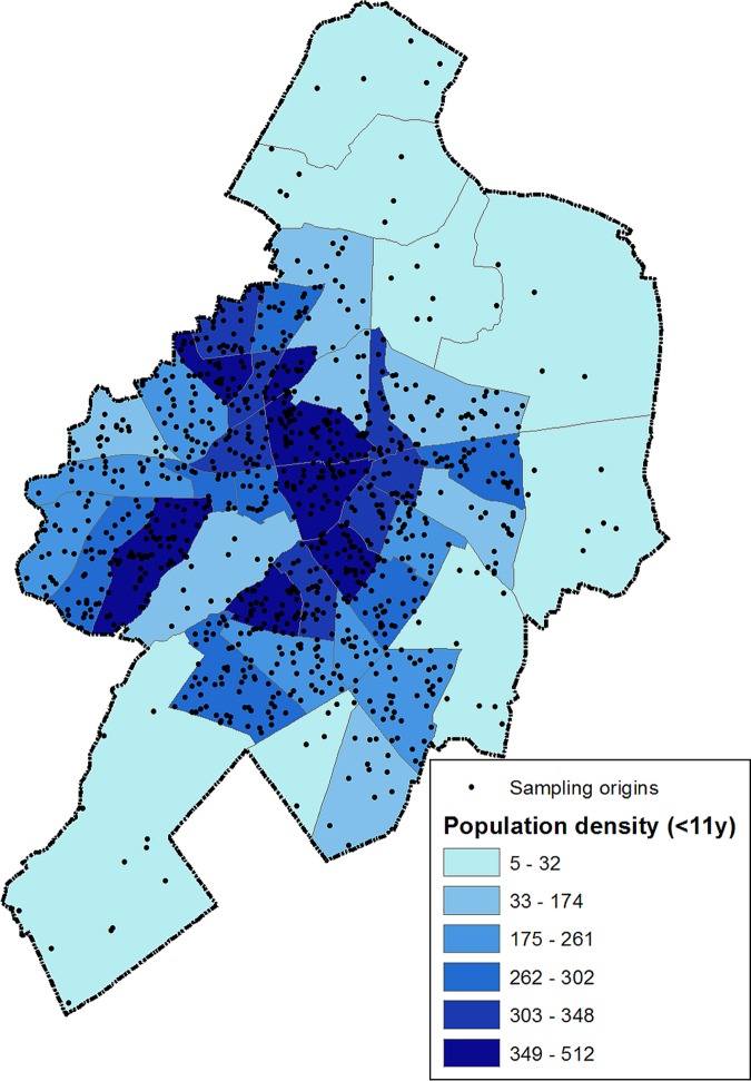
Data privacy is a major concern in spatial epidemiology because exact residential locations or parts of participants' addresses such as street or zip codes are used to perform geospatial analyses. To overcome this concern, different levels of aggregation such as census districts or zip code areas are mainly used, though any spatial aggregation leads to a loss of spatial variability. For the assessment of urban opportunities for physical activity that was conducted in the IDEFICS (Identification and prevention of dietary- and lifestyle-induced health effects in children and infants) study, macrolevel analyses were performed, but the use of exact residential addresses for micro-level analyses was not permitted by the responsible office for data protection. We therefore implemented a spatial blurring to anonymise address coordinates depending on the underlying population density.

METHODS

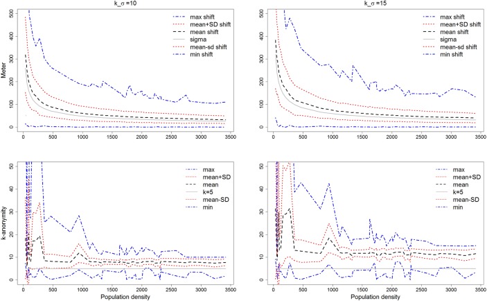
We added a standard Gaussian distributed error to individual address coordinates with the variance σ² depending on the population density and on the chosen k-anonymity. 1000 random point locations were generated and repeatedly blurred 100 times to obtain anonymised locations. For each location 1 km network-dependent neighbourhoods were used to calculate walkability indices. Indices of blurred locations were compared to indices based on their sampling origins to determine the effect of spatial blurring on the assessment of the built environment.

RESULTS

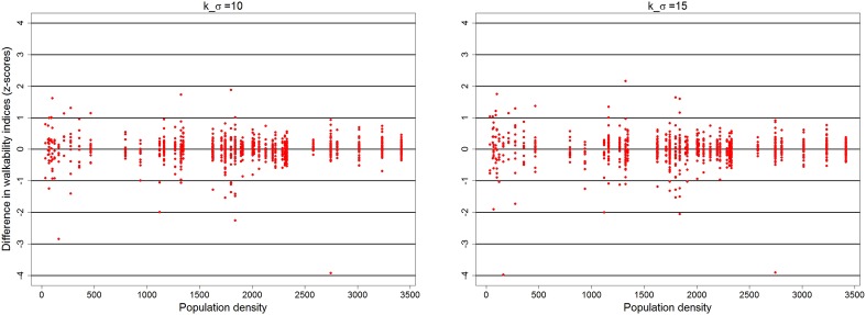
Spatial blurring decreased with increasing population density. Similarly, mean differences in walkability indices also decreased with increasing population density. In particular for densely-populated areas with at least 1500 residents per km², differences between blurred locations and their sampling origins were small and did not affect the assessment of the built environment after spatial blurring.

CONCLUSIONS

This approach allowed the investigation of the built environment at a microlevel using individual network-dependent neighbourhoods, while ensuring data protection requirements. Minor influence of spatial blurring on the assessment of walkability was found that slightly affected the assessment of the built environment in sparsely-populated areas.

摘要

背景

数据隐私是空间流行病学中的一个主要问题,因为在进行地理空间分析时会使用参与者的确切居住位置或地址的部分信息,如街道或邮政编码。为了克服这一问题,主要采用不同层次的聚合方式,如普查区或邮政编码区域,不过任何空间聚合都会导致空间变异性的损失。在IDEFICS(识别和预防儿童及婴儿饮食和生活方式引起的健康影响)研究中进行的城市体育活动机会评估采用了宏观层面的分析,但数据保护责任部门不允许在微观层面分析中使用确切的居住地址。因此,我们实施了空间模糊处理,根据潜在人口密度对地址坐标进行匿名化处理。

方法

我们向单个地址坐标添加了一个服从标准高斯分布的误差,其方差σ²取决于人口密度和所选的k匿名性。生成了1000个随机点位置,并重复模糊处理100次以获得匿名位置。对于每个位置,使用1公里的网络相关邻域来计算步行适宜性指数。将模糊位置的指数与其采样源的指数进行比较,以确定空间模糊对建成环境评估的影响。

结果

空间模糊程度随着人口密度的增加而降低。同样,步行适宜性指数的平均差异也随着人口密度的增加而减小。特别是对于每平方公里至少有1500名居民的人口密集地区,模糊位置与其采样源之间的差异很小,并且在空间模糊处理后不影响对建成环境的评估。

结论

这种方法允许在确保数据保护要求的同时,使用与网络相关的个体邻域在微观层面研究建成环境。发现空间模糊对步行适宜性评估的影响较小,在人口稀疏地区对建成环境评估有轻微影响。

https://cdn.ncbi.nlm.nih.gov/pmc/blobs/bf46/4360832/df62d9d1f339/bmjopen2014006481f03.jpg
https://cdn.ncbi.nlm.nih.gov/pmc/blobs/bf46/4360832/e92398d45e38/bmjopen2014006481f01.jpg
https://cdn.ncbi.nlm.nih.gov/pmc/blobs/bf46/4360832/8037f204a527/bmjopen2014006481f02.jpg
https://cdn.ncbi.nlm.nih.gov/pmc/blobs/bf46/4360832/df62d9d1f339/bmjopen2014006481f03.jpg
https://cdn.ncbi.nlm.nih.gov/pmc/blobs/bf46/4360832/e92398d45e38/bmjopen2014006481f01.jpg
https://cdn.ncbi.nlm.nih.gov/pmc/blobs/bf46/4360832/8037f204a527/bmjopen2014006481f02.jpg
https://cdn.ncbi.nlm.nih.gov/pmc/blobs/bf46/4360832/df62d9d1f339/bmjopen2014006481f03.jpg

相似文献

1
Anonymisation of address coordinates for microlevel analyses of the built environment: a simulation study.用于建筑环境微观层面分析的地址坐标匿名化:一项模拟研究。
BMJ Open. 2015 Mar 9;5(3):e006481. doi: 10.1136/bmjopen-2014-006481.
2
Spatial error in geocoding physician location data from the AMA Physician Masterfile: implications for spatial accessibility analysis.美国医学协会医师主文件中地理编码医师位置数据的空间误差:对空间可达性分析的影响。
Spat Spatiotemporal Epidemiol. 2012 Apr;3(1):31-8. doi: 10.1016/j.sste.2012.02.004. Epub 2012 Feb 15.
3
Objective measures of the built environment and physical activity in children: from walkability to moveability.儿童生存环境与身体活动的客观测量:从适宜步行性到可动性
J Urban Health. 2015 Feb;92(1):24-38. doi: 10.1007/s11524-014-9915-2.
4
Assessing opportunities for physical activity in the built environment of children: interrelation between kernel density and neighborhood scale.评估儿童建成环境中的身体活动机会:核密度与邻里规模之间的相互关系。
Int J Health Geogr. 2015 Dec 22;14:35. doi: 10.1186/s12942-015-0027-3.
5
Developing a research and practice tool to measure walkability: a demonstration project.开发一种用于衡量步行便利性的研究与实践工具:一个示范项目。
Health Promot J Austr. 2014 Dec;25(3):160-6. doi: 10.1071/HE14050.
6
Associations of neighbourhood walkability indices with weight gain.社区步行指数与体重增加的关系。
Int J Behav Nutr Phys Act. 2018 Apr 3;15(1):33. doi: 10.1186/s12966-018-0668-2.
7
Positional accuracy of geocoding from residential postal codes versus full street addresses.从住宅邮政编码与完整街道地址进行地理编码的位置准确性。
Health Rep. 2018 Feb 21;29(2):3-9.
8
Investigating impacts of positional error on potential health care accessibility.调查位置误差对潜在医疗保健可及性的影响。
Spat Spatiotemporal Epidemiol. 2012 Apr;3(1):17-29. doi: 10.1016/j.sste.2012.02.003. Epub 2012 Feb 23.
9
Neighbourhood built environment characteristics associated with different types of physical activity in Canadian adults.与加拿大成年人不同类型身体活动相关的邻里建成环境特征。
Health Promot Chronic Dis Prev Can. 2017 Jun;37(6):175-185. doi: 10.24095/hpcdp.37.6.01.
10
Walkability and walking for transport: characterizing the built environment using space syntax.适步行性与交通步行:运用空间句法描述建成环境
Int J Behav Nutr Phys Act. 2016 Nov 24;13(1):121. doi: 10.1186/s12966-016-0448-9.

引用本文的文献

1
A review of geospatial exposure models and approaches for health data integration.地理空间暴露模型与健康数据整合方法综述。
J Expo Sci Environ Epidemiol. 2025 Apr;35(2):131-148. doi: 10.1038/s41370-024-00712-8. Epub 2024 Sep 6.
2
Ecological Predictors of Older Adults' Participation and Retention in a Physical Activity Intervention.老年人参与和坚持体育活动干预的生态预测因素。
Int J Environ Res Public Health. 2022 Mar 8;19(6):3190. doi: 10.3390/ijerph19063190.
3
Urban Moveability and physical activity in children: longitudinal results from the IDEFICS and I.Family cohort.

本文引用的文献

1
Conceptualization and measurement of environmental exposure in epidemiology: accounting for activity space related to daily mobility.流行病学中环境暴露的概念化和测量:考虑与日常活动相关的活动空间。
Health Place. 2013 May;21:86-93. doi: 10.1016/j.healthplace.2013.01.005. Epub 2013 Feb 4.
2
Neighborhood walkability and active travel (walking and cycling) in New York City.纽约市的社区可步行性与积极出行(步行和骑行)。
J Urban Health. 2013 Aug;90(4):575-85. doi: 10.1007/s11524-012-9758-7.
3
Quantifying the magnitude of environmental exposure misclassification when using imprecise address proxies in public health research.
城市流动性与儿童身体活动:IDEFICS 和 I.Family 队列的纵向研究结果。
Int J Behav Nutr Phys Act. 2019 Dec 11;16(1):128. doi: 10.1186/s12966-019-0886-2.
4
"Spatial Energetics": Integrating Data From GPS, Accelerometry, and GIS to Address Obesity and Inactivity.“空间能量学”:整合来自全球定位系统、加速度测量法和地理信息系统的数据以应对肥胖和缺乏运动的问题。
Am J Prev Med. 2016 Nov;51(5):792-800. doi: 10.1016/j.amepre.2016.06.006. Epub 2016 Aug 12.
5
Assessing opportunities for physical activity in the built environment of children: interrelation between kernel density and neighborhood scale.评估儿童建成环境中的身体活动机会:核密度与邻里规模之间的相互关系。
Int J Health Geogr. 2015 Dec 22;14:35. doi: 10.1186/s12942-015-0027-3.
6
Objective measures of the built environment and physical activity in children: from walkability to moveability.儿童生存环境与身体活动的客观测量:从适宜步行性到可动性
J Urban Health. 2015 Feb;92(1):24-38. doi: 10.1007/s11524-014-9915-2.
在公共卫生研究中使用不精确的地址代理时,量化环境暴露错误分类的程度。
Spat Spatiotemporal Epidemiol. 2012 Apr;3(1):55-67. doi: 10.1016/j.sste.2012.02.006. Epub 2012 Feb 11.
4
Development and application of a moveability index to quantify possibilities for physical activity in the built environment of children.发展和应用活动能力指数来量化儿童建筑环境中身体活动的可能性。
Health Place. 2011 Nov;17(6):1191-201. doi: 10.1016/j.healthplace.2011.08.011. Epub 2011 Sep 5.
5
The IDEFICS cohort: design, characteristics and participation in the baseline survey.IDEFICS 队列:设计、特征和基线调查参与情况。
Int J Obes (Lond). 2011 Apr;35 Suppl 1:S3-15. doi: 10.1038/ijo.2011.30.
6
Mapping health data: improved privacy protection with donut method geomasking.健康数据映射:甜甜圈几何掩蔽法提升隐私保护
Am J Epidemiol. 2010 Nov 1;172(9):1062-9. doi: 10.1093/aje/kwq248. Epub 2010 Sep 3.
7
Musings on privacy issues in health research involving disaggregate geographic data about individuals.关于涉及个体离散地理位置数据的健康研究中隐私问题的思考。
Int J Health Geogr. 2009 Jul 20;8:46. doi: 10.1186/1476-072X-8-46.
8
The complexities of measuring access to parks and physical activity sites in New York City: a quantitative and qualitative approach.测量纽约市公园和体育活动场所可达性的复杂性:一种定量和定性的方法。
Int J Health Geogr. 2009 Jun 22;8:34. doi: 10.1186/1476-072X-8-34.
9
Measuring the built environment for physical activity: state of the science.测量促进身体活动的建成环境:科学现状
Am J Prev Med. 2009 Apr;36(4 Suppl):S99-123.e12. doi: 10.1016/j.amepre.2009.01.005.
10
Re-identification of home addresses from spatial locations anonymized by Gaussian skew.从经高斯偏斜匿名化的空间位置重新识别家庭住址。
Int J Health Geogr. 2008 Aug 12;7:45. doi: 10.1186/1476-072X-7-45.