Hanan Niall P, Tredennick Andrew T, Prihodko Lara, Bucini Gabriela, Dohn Justin
Geospatial Sciences Center of Excellence, South Dakota State University Brookings, SD, 57007, USA.
Natural Resource Ecology Laboratory, Graduate Degree Program in Ecology, Colorado State University Fort Collins, CO, 80523, USA.
Glob Ecol Biogeogr. 2014 Mar;23(3):259-263. doi: 10.1111/geb.12122. Epub 2013 Oct 29.
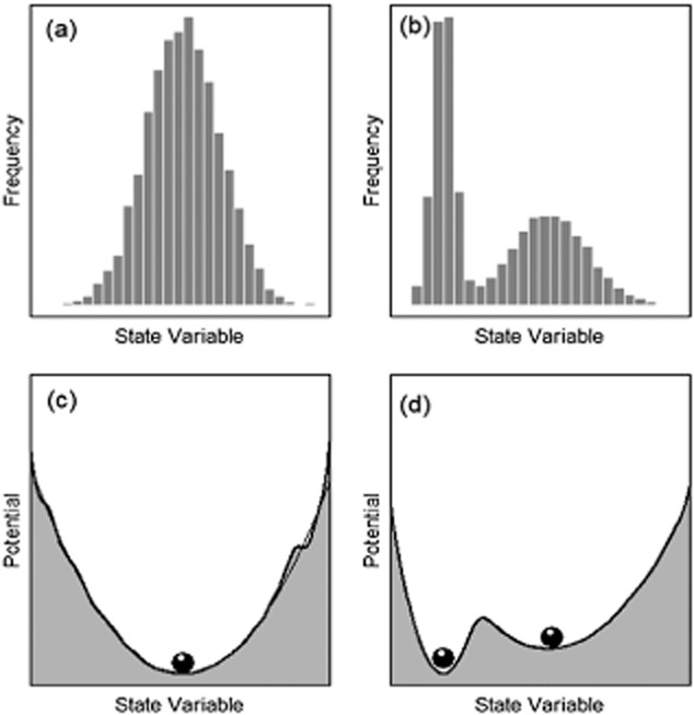
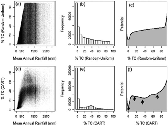
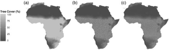
Multiple stable states, bifurcations and thresholds are fashionable concepts in the ecological literature, a recognition that complex ecosystems may at times exhibit the interesting dynamic behaviours predicted by relatively simple biomathematical models. Recently, several papers in , and elsewhere have attempted to quantify the prevalence of alternate stable states in the savannas of Africa, Australia and South America, and the tundra-taiga-grassland transitions of the circum-boreal region using satellite-derived woody canopy cover. While we agree with the logic that basins of attraction can be inferred from the relative frequencies of ecosystem states observed in space and time, we caution that the statistical methodologies underlying the satellite product used in these studies may confound our ability to infer the presence of multiple stable states. We demonstrate this point using a uniformly distributed 'pseudo-tree cover' database for Africa that we use to retrace the steps involved in creation of the satellite tree-cover product and subsequent analysis. We show how classification and regression tree (CART)-based products may impose discontinuities in satellite tree-cover estimates even when such discontinuities are not present in reality. As regional and global remote sensing and geospatial data become more easily accessible for ecological studies, we recommend careful consideration of how error distributions in remote sensing products may interact with the data needs and theoretical expectations of the ecological process under study.
多重稳定状态、分岔和阈值是生态文献中的流行概念,这表明复杂的生态系统有时可能会展现出相对简单的生物数学模型所预测的有趣动态行为。最近,《》《》以及其他地方的几篇论文试图利用卫星衍生的木本植被覆盖度,量化非洲、澳大利亚和南美洲稀树草原以及环北极地区苔原 - 泰加林 - 草原过渡带中交替稳定状态的普遍程度。虽然我们认同可以从时空上观测到的生态系统状态的相对频率推断吸引域这一逻辑,但我们提醒,这些研究中所使用的卫星产品背后的统计方法可能会干扰我们推断多重稳定状态存在的能力。我们使用非洲的一个均匀分布的 “伪树木覆盖度 ”数据库来证明这一点,我们用它来追溯创建卫星树木覆盖度产品及后续分析所涉及的步骤过程。我们展示了基于分类和回归树(CART ) 的产品如何即使在现实中不存在不连续性的情况下,也可能在卫星树木覆盖度估计中造成不连续性。随着区域和全球遥感及地理空间数据在生态研究中变得更容易获取到,我们建议仔细考虑遥感产品中的误差分布如何可能会与所研究的生态过程的数据需求和理论预期相互作用。