• 文献检索
  • 文档翻译
  • 深度研究
  • 学术资讯
  • Suppr Zotero 插件Zotero 插件
  • 邀请有礼
  • 套餐&价格
  • 历史记录
应用&插件
Suppr Zotero 插件Zotero 插件浏览器插件Mac 客户端Windows 客户端微信小程序
定价
高级版会员购买积分包购买API积分包
服务
文献检索文档翻译深度研究API 文档MCP 服务
关于我们
关于 Suppr公司介绍联系我们用户协议隐私条款
关注我们

Suppr 超能文献

核心技术专利:CN118964589B侵权必究
粤ICP备2023148730 号-1Suppr @ 2026

文献检索

告别复杂PubMed语法,用中文像聊天一样搜索,搜遍4000万医学文献。AI智能推荐,让科研检索更轻松。

立即免费搜索

文件翻译

保留排版,准确专业,支持PDF/Word/PPT等文件格式,支持 12+语言互译。

免费翻译文档

深度研究

AI帮你快速写综述,25分钟生成高质量综述,智能提取关键信息,辅助科研写作。

立即免费体验

适用于无人机系统(UASs)的高效森林火灾检测指数

Efficient Forest Fire Detection Index for Application in Unmanned Aerial Systems (UASs).

作者信息

Cruz Henry, Eckert Martina, Meneses Juan, Martínez José-Fernán

机构信息

Research Center on Software Technologies and Multimedia Systems for Sustainability (CITSEM), Universidad Politécnica de Madrid, Alan Turing St., Madrid 28031, Spain.

出版信息

Sensors (Basel). 2016 Jun 16;16(6):893. doi: 10.3390/s16060893.

DOI:10.3390/s16060893
PMID:27322264
原文链接:https://pmc.ncbi.nlm.nih.gov/articles/PMC4934319/
Abstract

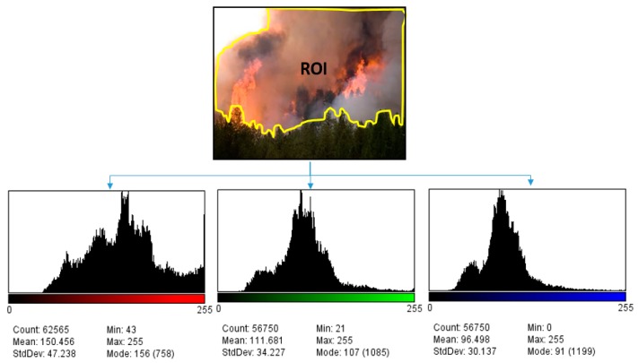
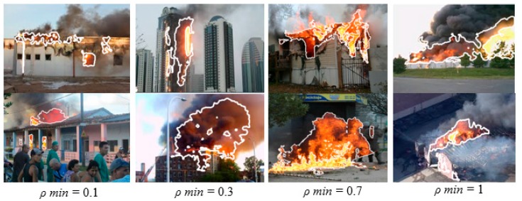
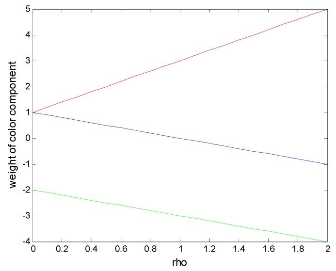
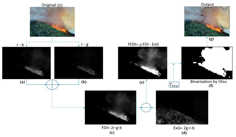
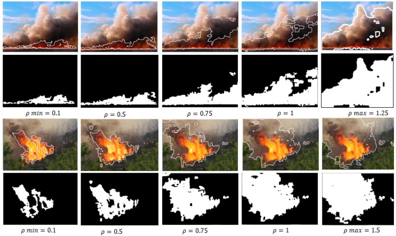
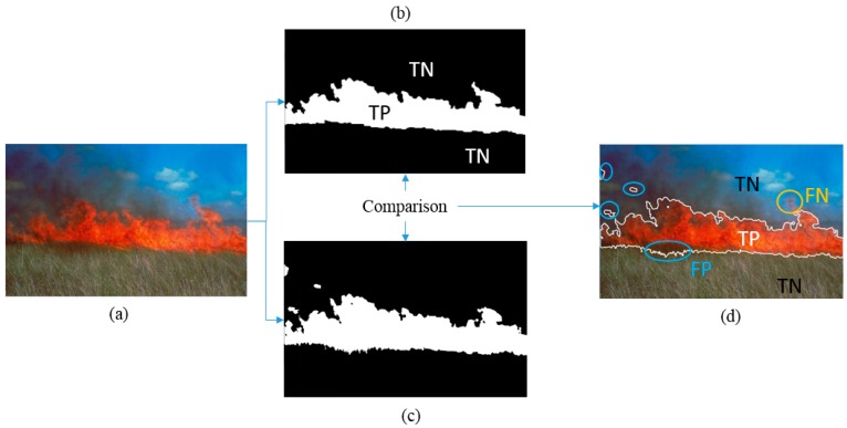
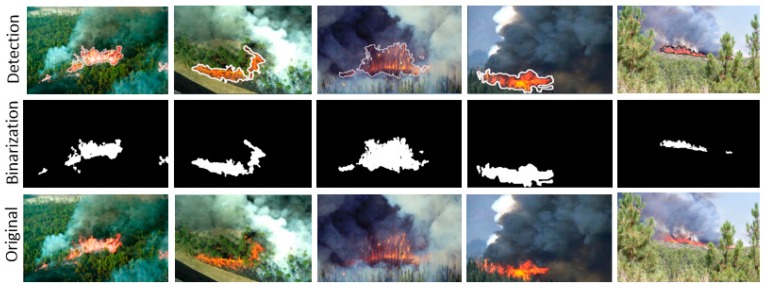
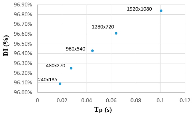
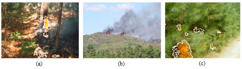
This article proposes a novel method for detecting forest fires, through the use of a new color index, called the Forest Fire Detection Index (FFDI), developed by the authors. The index is based on methods for vegetation classification and has been adapted to detect the tonalities of flames and smoke; the latter could be included adaptively into the Regions of Interest (RoIs) with the help of a variable factor. Multiple tests have been performed upon database imagery and present promising results: a detection precision of 96.82% has been achieved for image sizes of 960 × 540 pixels at a processing time of 0.0447 seconds. This achievement would lead to a performance of 22 f/s, for smaller images, while up to 54 f/s could be reached by maintaining a similar detection precision. Additional tests have been performed on fires in their early stages, achieving a precision rate of p = 96.62%. The method could be used in real-time in Unmanned Aerial Systems (UASs), with the aim of monitoring a wider area than through fixed surveillance systems. Thus, it would result in more cost-effective outcomes than conventional systems implemented in helicopters or satellites. UASs could also reach inaccessible locations without jeopardizing people's safety. On-going work includes implementation into a commercially available drone.

摘要

本文提出了一种检测森林火灾的新方法,该方法通过使用作者开发的一种名为森林火灾检测指数(FFDI)的新颜色指数来实现。该指数基于植被分类方法,并已进行调整以检测火焰和烟雾的色调;借助一个可变因子,烟雾可以自适应地纳入感兴趣区域(RoI)。已对数据库图像进行了多次测试,结果很有前景:对于960×540像素的图像尺寸,在0.0447秒的处理时间内实现了96.82%的检测精度。对于较小的图像,这一成果将带来22帧/秒的性能,而通过保持相似的检测精度,可达54帧/秒。还对早期火灾进行了额外测试,获得了p = 96.62%的准确率。该方法可在无人航空系统(UAS)中实时使用,目的是监测比通过固定监控系统更广阔的区域。因此,与直升机或卫星上实施的传统系统相比,它将产生更具成本效益的结果。UAS还可以到达难以到达的地点,而不会危及人员安全。正在进行的工作包括将其应用于商用无人机。

https://cdn.ncbi.nlm.nih.gov/pmc/blobs/ca4f/4934319/ba5183af89a6/sensors-16-00893-g009.jpg
https://cdn.ncbi.nlm.nih.gov/pmc/blobs/ca4f/4934319/ceea13f31d3d/sensors-16-00893-g001.jpg
https://cdn.ncbi.nlm.nih.gov/pmc/blobs/ca4f/4934319/83ea3c3412a0/sensors-16-00893-g002.jpg
https://cdn.ncbi.nlm.nih.gov/pmc/blobs/ca4f/4934319/abf96c56cd91/sensors-16-00893-g003.jpg
https://cdn.ncbi.nlm.nih.gov/pmc/blobs/ca4f/4934319/749d173d494d/sensors-16-00893-g004.jpg
https://cdn.ncbi.nlm.nih.gov/pmc/blobs/ca4f/4934319/3d99f674a770/sensors-16-00893-g005.jpg
https://cdn.ncbi.nlm.nih.gov/pmc/blobs/ca4f/4934319/78a7a7d0e224/sensors-16-00893-g006.jpg
https://cdn.ncbi.nlm.nih.gov/pmc/blobs/ca4f/4934319/bf8e1090667a/sensors-16-00893-g007.jpg
https://cdn.ncbi.nlm.nih.gov/pmc/blobs/ca4f/4934319/4a9491d0063a/sensors-16-00893-g008.jpg
https://cdn.ncbi.nlm.nih.gov/pmc/blobs/ca4f/4934319/ba5183af89a6/sensors-16-00893-g009.jpg

相似文献

1
Efficient Forest Fire Detection Index for Application in Unmanned Aerial Systems (UASs).适用于无人机系统(UASs)的高效森林火灾检测指数
Sensors (Basel). 2016 Jun 16;16(6):893. doi: 10.3390/s16060893.
2
Automatic forest-fire measuring using ground stations and Unmanned Aerial Systems.利用地面站和无人机系统自动测量森林火灾。
Sensors (Basel). 2011;11(6):6328-53. doi: 10.3390/s110606328. Epub 2011 Jun 16.
3
Development of a deep learning-based surveillance system for forest fire detection and monitoring using UAV.基于深度学习的无人机森林火灾监测系统的开发。
PLoS One. 2024 Mar 12;19(3):e0299058. doi: 10.1371/journal.pone.0299058. eCollection 2024.
4
Early Detection of Forest Fire Using Mixed Learning Techniques and UAV.利用混合学习技术和无人机进行森林火灾的早期检测。
Comput Intell Neurosci. 2022 Jul 9;2022:3170244. doi: 10.1155/2022/3170244. eCollection 2022.
5
UAVs-FFDB: A high-resolution dataset for advancing forest fire detection and monitoring using unmanned aerial vehicles (UAVs).无人机-森林火灾数据库(UAVs-FFDB):一个用于推进利用无人机(UAV)进行森林火灾检测和监测的高分辨率数据集。
Data Brief. 2024 Jul 3;55:110706. doi: 10.1016/j.dib.2024.110706. eCollection 2024 Aug.
6
Saliency Detection and Deep Learning-Based Wildfire Identification in UAV Imagery.无人机图像中基于显著性检测和深度学习的野火识别
Sensors (Basel). 2018 Feb 27;18(3):712. doi: 10.3390/s18030712.
7
Monitoring opencast mine restorations using Unmanned Aerial System (UAS) imagery.使用无人机系统(UAS)图像监测露天矿复垦。
Sci Total Environ. 2019 Mar 20;657:1602-1614. doi: 10.1016/j.scitotenv.2018.12.156. Epub 2018 Dec 13.
8
Landscape development, forest fires, and wilderness management.景观开发、森林火灾与荒野管理。
Science. 1974 Nov 8;186(4163):487-95. doi: 10.1126/science.186.4163.487.
9
Forest Fire Smoke Detection Based on Deep Learning Approaches and Unmanned Aerial Vehicle Images.基于深度学习方法和无人机图像的森林火灾烟雾检测
Sensors (Basel). 2023 Jun 19;23(12):5702. doi: 10.3390/s23125702.
10
Advances in Unmanned Aerial System Remote Sensing for Precision Viticulture.无人航空系统遥感在精准园艺学中的应用进展。
Sensors (Basel). 2021 Feb 1;21(3):956. doi: 10.3390/s21030956.

引用本文的文献

1
Weakly-Supervised Transfer Learning with Application in Precision Medicine.弱监督迁移学习及其在精准医学中的应用
IEEE Trans Autom Sci Eng. 2024 Oct;21(4):6250-6264. doi: 10.1109/tase.2023.3323773. Epub 2023 Oct 23.
2
Forest Fire Smoke Detection Based on Deep Learning Approaches and Unmanned Aerial Vehicle Images.基于深度学习方法和无人机图像的森林火灾烟雾检测
Sensors (Basel). 2023 Jun 19;23(12):5702. doi: 10.3390/s23125702.
3
Instance segmentation using semi-supervised learning for fire recognition.使用半监督学习进行火灾识别的实例分割

本文引用的文献

1
Quantifying efficacy and limits of unmanned aerial vehicle (UAV) technology for weed seedling detection as affected by sensor resolution.量化受传感器分辨率影响的无人机(UAV)技术在杂草幼苗检测方面的功效及局限性。
Sensors (Basel). 2015 Mar 6;15(3):5609-26. doi: 10.3390/s150305609.
2
An early fire detection algorithm using IP cameras.基于 IP 摄像机的早期火灾检测算法。
Sensors (Basel). 2012;12(5):5670-86. doi: 10.3390/s120505670. Epub 2012 May 3.
3
Early forest fire detection using radio-acoustic sounding system.利用无线电声学探测系统进行早期森林火灾探测。
Heliyon. 2022 Dec 16;8(12):e12375. doi: 10.1016/j.heliyon.2022.e12375. eCollection 2022 Dec.
4
An Embedded Portable Lightweight Platform for Real-Time Early Smoke Detection.用于实时早期烟雾检测的嵌入式便携式轻量级平台。
Sensors (Basel). 2022 Jun 20;22(12):4655. doi: 10.3390/s22124655.
5
Scalable Fire and Smoke Segmentation from Aerial Images Using Convolutional Neural Networks and Quad-Tree Search.基于卷积神经网络和四叉树搜索的航空影像可扩展火灾与烟雾分割。
Sensors (Basel). 2022 Feb 22;22(5):1701. doi: 10.3390/s22051701.
6
Autonomous Navigation of a Team of Unmanned Surface Vehicles for Intercepting Intruders on a Region Boundary.一组无人水面航行器在区域边界拦截入侵者的自主导航
Sensors (Basel). 2021 Jan 4;21(1):297. doi: 10.3390/s21010297.
7
Scaling Effects on Chlorophyll Content Estimations with RGB Camera Mounted on a UAV Platform Using Machine-Learning Methods.基于机器学习的无人机 RGB 相机叶绿素含量估算的尺度效应。
Sensors (Basel). 2020 Sep 9;20(18):5130. doi: 10.3390/s20185130.
8
A Multi-Feature and Multi-Level Matching Algorithm Using Aerial Image and AIS for Vessel Identification.基于航空图像和 AIS 的多特征多层次匹配算法在船舶识别中的应用
Sensors (Basel). 2019 Mar 15;19(6):1317. doi: 10.3390/s19061317.
9
Where There Is Fire There Is SMOKE: A Scalable Edge Computing Framework for Early Fire Detection.有火就有烟:一种用于早期火灾检测的可扩展边缘计算框架。
Sensors (Basel). 2019 Feb 3;19(3):639. doi: 10.3390/s19030639.
10
Using Unmanned Aerial Vehicles in Postfire Vegetation Survey Campaigns through Large and Heterogeneous Areas: Opportunities and Challenges.利用无人机在大而多样的火灾后植被调查活动中:机遇与挑战。
Sensors (Basel). 2018 Feb 14;18(2):586. doi: 10.3390/s18020586.
Sensors (Basel). 2009;9(3):1485-98. doi: 10.3390/s90301485. Epub 2009 Mar 3.
4
A Contextual Fire Detection Algorithm for Simulated HJ-1B Imagery.针对 HJ-1B 图像的上下文火灾检测算法。
Sensors (Basel). 2009;9(2):961-79. doi: 10.3390/s90200961. Epub 2009 Feb 13.
5
Automatic forest-fire measuring using ground stations and Unmanned Aerial Systems.利用地面站和无人机系统自动测量森林火灾。
Sensors (Basel). 2011;11(6):6328-53. doi: 10.3390/s110606328. Epub 2011 Jun 16.
6
Climate change and forest fires.气候变化与森林火灾。
Sci Total Environ. 2000 Nov 15;262(3):221-9. doi: 10.1016/s0048-9697(00)00524-6.