文献检索文档翻译深度研究
Suppr Zotero 插件Zotero 插件
邀请有礼套餐&价格历史记录

新学期,新优惠

限时优惠:9月1日-9月22日

30天高级会员仅需29元

1天体验卡首发特惠仅需5.99元

了解详情
不再提醒
插件&应用
Suppr Zotero 插件Zotero 插件浏览器插件Mac 客户端Windows 客户端微信小程序
高级版
套餐订阅购买积分包
AI 工具
文献检索文档翻译深度研究
关于我们
关于 Suppr公司介绍联系我们用户协议隐私条款
关注我们

Suppr 超能文献

核心技术专利:CN118964589B侵权必究
粤ICP备2023148730 号-1Suppr @ 2025

量化受传感器分辨率影响的无人机(UAV)技术在杂草幼苗检测方面的功效及局限性。

Quantifying efficacy and limits of unmanned aerial vehicle (UAV) technology for weed seedling detection as affected by sensor resolution.

作者信息

Peña José M, Torres-Sánchez Jorge, Serrano-Pérez Angélica, de Castro Ana I, López-Granados Francisca

机构信息

Institute for Sustainable Agriculture, IAS-CSIC, P.O. Box 4084, 14080 Córdoba, Spain.

出版信息

Sensors (Basel). 2015 Mar 6;15(3):5609-26. doi: 10.3390/s150305609.


DOI:10.3390/s150305609
PMID:25756867
原文链接:https://pmc.ncbi.nlm.nih.gov/articles/PMC4435221/
Abstract

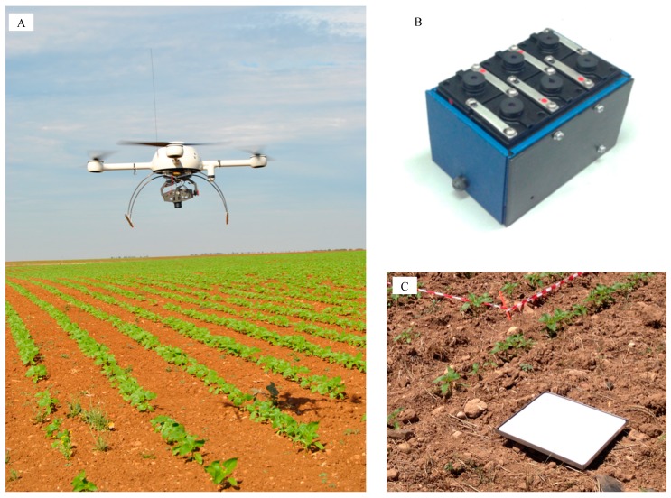
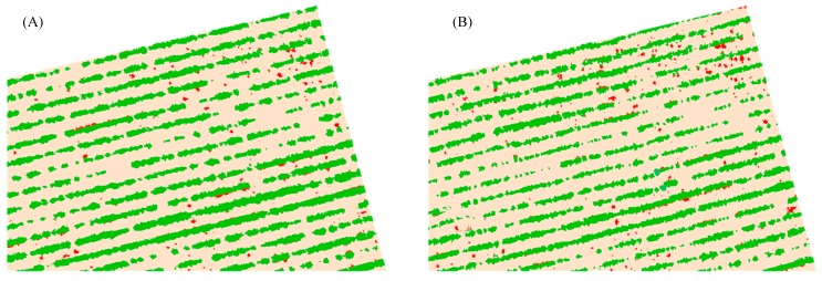
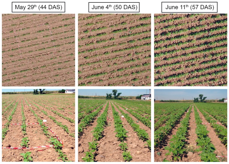
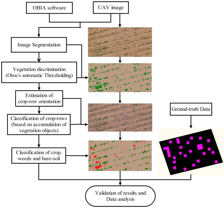
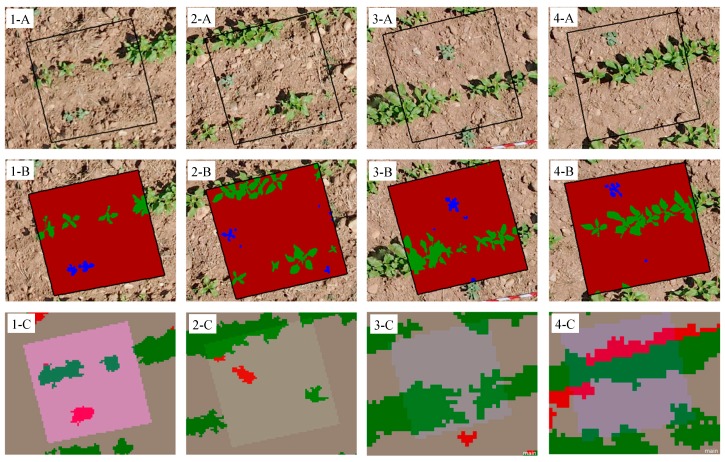
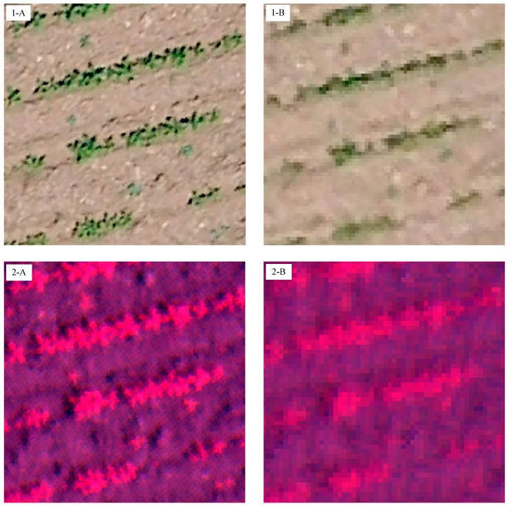
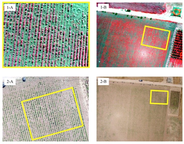
In order to optimize the application of herbicides in weed-crop systems, accurate and timely weed maps of the crop-field are required. In this context, this investigation quantified the efficacy and limitations of remote images collected with an unmanned aerial vehicle (UAV) for early detection of weed seedlings. The ability to discriminate weeds was significantly affected by the imagery spectral (type of camera), spatial (flight altitude) and temporal (the date of the study) resolutions. The colour-infrared images captured at 40 m and 50 days after sowing (date 2), when plants had 5-6 true leaves, had the highest weed detection accuracy (up to 91%). At this flight altitude, the images captured before date 2 had slightly better results than the images captured later. However, this trend changed in the visible-light images captured at 60 m and higher, which had notably better results on date 3 (57 days after sowing) because of the larger size of the weed plants. Our results showed the requirements on spectral and spatial resolutions needed to generate a suitable weed map early in the growing season, as well as the best moment for the UAV image acquisition, with the ultimate objective of applying site-specific weed management operations.

摘要

为了优化除草剂在杂草 - 作物系统中的应用,需要准确及时的农田杂草地图。在此背景下,本研究量化了使用无人机(UAV)收集的遥感图像对杂草幼苗进行早期检测的效果和局限性。区分杂草的能力受到图像光谱(相机类型)、空间(飞行高度)和时间(研究日期)分辨率的显著影响。在播种后40米和50天(日期2)拍摄的彩色红外图像,此时植株有5 - 6片真叶,杂草检测准确率最高(高达91%)。在此飞行高度下,日期2之前拍摄的图像比之后拍摄的图像效果略好。然而,在60米及更高高度拍摄的可见光图像中,这种趋势发生了变化,由于杂草植株较大,在日期3(播种后57天)的效果明显更好。我们的结果显示了在生长季节早期生成合适杂草地图所需的光谱和空间分辨率要求,以及无人机图像采集的最佳时机,最终目标是应用精准的杂草管理操作。

https://cdn.ncbi.nlm.nih.gov/pmc/blobs/a883/4435221/53853b010012/sensors-15-05609-g007.jpg
https://cdn.ncbi.nlm.nih.gov/pmc/blobs/a883/4435221/e673aafe7d36/sensors-15-05609-g001.jpg
https://cdn.ncbi.nlm.nih.gov/pmc/blobs/a883/4435221/9b8188126856/sensors-15-05609-g002.jpg
https://cdn.ncbi.nlm.nih.gov/pmc/blobs/a883/4435221/7e7d41d8247b/sensors-15-05609-g003.jpg
https://cdn.ncbi.nlm.nih.gov/pmc/blobs/a883/4435221/f52c5559b1a2/sensors-15-05609-g004.jpg
https://cdn.ncbi.nlm.nih.gov/pmc/blobs/a883/4435221/8d1117a984b2/sensors-15-05609-g005.jpg
https://cdn.ncbi.nlm.nih.gov/pmc/blobs/a883/4435221/e677effd5027/sensors-15-05609-g006.jpg
https://cdn.ncbi.nlm.nih.gov/pmc/blobs/a883/4435221/53853b010012/sensors-15-05609-g007.jpg

相似文献

[1]
Quantifying efficacy and limits of unmanned aerial vehicle (UAV) technology for weed seedling detection as affected by sensor resolution.

Sensors (Basel). 2015-3-6

[2]
Configuration and specifications of an Unmanned Aerial Vehicle (UAV) for early site specific weed management.

PLoS One. 2013-3-6

[3]
Weed mapping in early-season maize fields using object-based analysis of unmanned aerial vehicle (UAV) images.

PLoS One. 2013-10-11

[4]
A fully convolutional network for weed mapping of unmanned aerial vehicle (UAV) imagery.

PLoS One. 2018-4-26

[5]
Spatial Quality Evaluation of Resampled Unmanned Aerial Vehicle-Imagery for Weed Mapping.

Sensors (Basel). 2015-8-12

[6]
Integration of remote-weed mapping and an autonomous spraying unmanned aerial vehicle for site-specific weed management.

Pest Manag Sci. 2019-11-12

[7]
A novel semi-supervised framework for UAV based crop/weed classification.

PLoS One. 2021

[8]
Identification and Comprehensive Evaluation of Resistant Weeds Using Unmanned Aerial Vehicle-Based Multispectral Imagery.

Front Plant Sci. 2022-7-5

[9]
Coupling of machine learning methods to improve estimation of ground coverage from unmanned aerial vehicle (UAV) imagery for high-throughput phenotyping of crops.

Funct Plant Biol. 2021-7

[10]
Improved weed mapping in corn fields by combining UAV-based spectral, textural, structural, and thermal measurements.

Pest Manag Sci. 2023-7

引用本文的文献

[1]
GSP-AI: An AI-Powered Platform for Identifying Key Growth Stages and the Vegetative-to-Reproductive Transition in Wheat Using Trilateral Drone Imagery and Meteorological Data.

Plant Phenomics. 2024-10-9

[2]
Boosting precision crop protection towards agriculture 5.0 machine learning and emerging technologies: A contextual review.

Front Plant Sci. 2023-3-22

[3]
A Comprehensive Review of High Throughput Phenotyping and Machine Learning for Plant Stress Phenotyping.

Phenomics. 2022-4-4

[4]
Detection of Ecballium elaterium in hedgerow olive orchards using a low-cost uncrewed aerial vehicle and open-source algorithms.

Pest Manag Sci. 2023-2

[5]
Proximal and remote sensing in plant phenomics: 20 years of progress, challenges, and perspectives.

Plant Commun. 2022-11-14

[6]
The Use of Very-High-Resolution Aerial Imagery to Estimate the Structure and Distribution of the Community for Long-Term Monitoring in Desert Ecosystems.

Plants (Basel). 2021-5-13

[7]
An image segmentation technique with statistical strategies for pesticide efficacy assessment.

PLoS One. 2021

[8]
Creating Predictive Weed Emergence Models Using Repeat Photography and Image Analysis.

Plants (Basel). 2020-5-15

[9]
A Framework for Multiple Ground Target Finding and Inspection Using a Multirotor UAS.

Sensors (Basel). 2020-1-3

[10]
High-Throughput System for the Early Quantification of Major Architectural Traits in Olive Breeding Trials Using UAV Images and OBIA Techniques.

Front Plant Sci. 2019-11-18

本文引用的文献

[1]
Assessment of Unmanned Aerial Vehicles Imagery for Quantitative Monitoring of Wheat Crop in Small Plots.

Sensors (Basel). 2008-5-26

[2]
Geographic Object-Based Image Analysis - Towards a new paradigm.

ISPRS J Photogramm Remote Sens. 2014-1

[3]
Weed mapping in early-season maize fields using object-based analysis of unmanned aerial vehicle (UAV) images.

PLoS One. 2013-10-11

[4]
Configuration and specifications of an Unmanned Aerial Vehicle (UAV) for early site specific weed management.

PLoS One. 2013-3-6

文献AI研究员

20分钟写一篇综述,助力文献阅读效率提升50倍

立即体验

用中文搜PubMed

大模型驱动的PubMed中文搜索引擎

马上搜索

推荐工具

医学文档翻译智能文献检索