• 文献检索
  • 文档翻译
  • 深度研究
  • 学术资讯
  • Suppr Zotero 插件Zotero 插件
  • 邀请有礼
  • 套餐&价格
  • 历史记录
应用&插件
Suppr Zotero 插件Zotero 插件浏览器插件Mac 客户端Windows 客户端微信小程序
定价
高级版会员购买积分包购买API积分包
服务
文献检索文档翻译深度研究API 文档MCP 服务
关于我们
关于 Suppr公司介绍联系我们用户协议隐私条款
关注我们

Suppr 超能文献

核心技术专利:CN118964589B侵权必究
粤ICP备2023148730 号-1Suppr @ 2026

文献检索

告别复杂PubMed语法,用中文像聊天一样搜索,搜遍4000万医学文献。AI智能推荐,让科研检索更轻松。

立即免费搜索

文件翻译

保留排版,准确专业,支持PDF/Word/PPT等文件格式,支持 12+语言互译。

免费翻译文档

深度研究

AI帮你快速写综述,25分钟生成高质量综述,智能提取关键信息,辅助科研写作。

立即免费体验

将空间折线数据转换为网络格式的协议及在世界城市道路网络中的应用。

A protocol to convert spatial polyline data to network formats and applications to world urban road networks.

机构信息

Complex and Sustainable Urban Networks (CSUN) Lab, Department of Civil and Materials Engineering, University of Illinois at Chicago, Chicago, Illinois 60607, USA.

School of Architecture, University of North Carolina at Charlotte, Charlotte, North Carolina 28223, USA.

出版信息

Sci Data. 2016 Jun 21;3:160046. doi: 10.1038/sdata.2016.46.

DOI:10.1038/sdata.2016.46
PMID:27327129
原文链接:https://pmc.ncbi.nlm.nih.gov/articles/PMC4915275/
Abstract

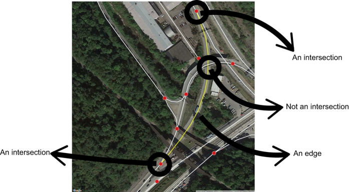
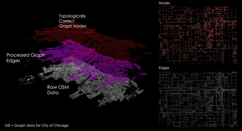
The study of geographical systems as graphs, and networks has gained significant momentum in the academic literature as these systems possess measurable and relevant network properties. Crowd-based sources of data such as OpenStreetMaps (OSM) have created a wealth of worldwide geographic information including on transportation systems (e.g., road networks). In this work, we offer a Geographic Information Systems (GIS) protocol to transfer polyline data into a workable network format in the form of; a node layer, an edge layer, and a list of nodes/edges with relevant geographic information (e.g., length). Moreover, we have developed an ArcGIS tool to perform this protocol on OSM data, which we have applied to 80 urban areas in the world and made the results freely available. The tool accounts for crossover roads such as ramps and bridges. A separate tool is also made available for planar data and can be applied to any line features in ArcGIS.

摘要

将地理系统作为图和网络进行研究在学术文献中得到了很大的关注,因为这些系统具有可测量和相关的网络属性。基于众包的数据来源,如 OpenStreetMaps(OSM),创建了大量的全球地理信息,包括交通系统(例如,道路网络)。在这项工作中,我们提供了一个地理信息系统(GIS)协议,将折线数据转换为可操作的网络格式,包括节点层、边层以及带有相关地理信息(例如,长度)的节点/边列表。此外,我们还开发了一个 ArcGIS 工具来执行 OSM 数据上的这个协议,我们已经将其应用于全球 80 个城市,并免费提供结果。该工具考虑了交叉道路,如匝道和桥梁。还提供了一个用于平面数据的单独工具,可以应用于 ArcGIS 中的任何线要素。

https://cdn.ncbi.nlm.nih.gov/pmc/blobs/2699/4915275/0eb01b543a5b/sdata201646-f3.jpg
https://cdn.ncbi.nlm.nih.gov/pmc/blobs/2699/4915275/3a32b8eaa3e0/sdata201646-f1.jpg
https://cdn.ncbi.nlm.nih.gov/pmc/blobs/2699/4915275/a32c2fe572cf/sdata201646-f2.jpg
https://cdn.ncbi.nlm.nih.gov/pmc/blobs/2699/4915275/0eb01b543a5b/sdata201646-f3.jpg
https://cdn.ncbi.nlm.nih.gov/pmc/blobs/2699/4915275/3a32b8eaa3e0/sdata201646-f1.jpg
https://cdn.ncbi.nlm.nih.gov/pmc/blobs/2699/4915275/a32c2fe572cf/sdata201646-f2.jpg
https://cdn.ncbi.nlm.nih.gov/pmc/blobs/2699/4915275/0eb01b543a5b/sdata201646-f3.jpg

相似文献

1
A protocol to convert spatial polyline data to network formats and applications to world urban road networks.将空间折线数据转换为网络格式的协议及在世界城市道路网络中的应用。
Sci Data. 2016 Jun 21;3:160046. doi: 10.1038/sdata.2016.46.
2
Folic acid supplementation and malaria susceptibility and severity among people taking antifolate antimalarial drugs in endemic areas.在流行地区,服用抗叶酸抗疟药物的人群中,叶酸补充剂与疟疾易感性和严重程度的关系。
Cochrane Database Syst Rev. 2022 Feb 1;2(2022):CD014217. doi: 10.1002/14651858.CD014217.
3
Typology, network features and damage response in worldwide urban road systems.全球城市道路系统的类型学、网络特征及损伤响应
PLoS One. 2022 Mar 1;17(3):e0264546. doi: 10.1371/journal.pone.0264546. eCollection 2022.
4
Local network connectivity optimization: an evaluation of heuristics applied to complex spatial networks, a transportation case study, and a spatial social network.本地网络连接优化:对应用于复杂空间网络的启发式算法的评估、一个交通案例研究以及一个空间社会网络
PeerJ Comput Sci. 2021 Jun 18;7:e605. doi: 10.7717/peerj-cs.605. eCollection 2021.
5
Spatial data and workflow automation for understanding densification patterns and transport energy networks in urban areas: The cases of Bergen, Norway, and Zürich, Switzerland.用于理解城市地区致密化模式和交通能源网络的空间数据与工作流自动化:以挪威卑尔根和瑞士苏黎世为例。
Data Brief. 2022 May 18;42:108290. doi: 10.1016/j.dib.2022.108290. eCollection 2022 Jun.
6
Normative models and healthcare planning: network-based simulations within a geographic information system environment.规范模型与医疗保健规划:地理信息系统环境下基于网络的模拟
Health Serv Res. 1997 Jun;32(2):243-60.
7
Using GIS-based multicriteria decision support system for planning road networks with visual quality constraints: a case study of protected areas in Ankara, Turkey.基于 GIS 的多准则决策支持系统在具有视觉质量约束的道路网络规划中的应用:以土耳其安卡拉保护区为例。
Environ Monit Assess. 2020 Jun 22;192(7):447. doi: 10.1007/s10661-020-08417-9.
8
An integrated material metabolism model for stocks of urban road system in Beijing, China.中国北京市城市道路系统存量综合物质代谢模型。
Sci Total Environ. 2014 Feb 1;470-471:883-94. doi: 10.1016/j.scitotenv.2013.10.041. Epub 2013 Nov 6.
9
Encapsulating urban traffic rhythms into road networks.将城市交通节奏融入道路网络。
Sci Rep. 2014 Feb 20;4:4141. doi: 10.1038/srep04141.
10
NetSets.js: a JavaScript framework for compositional assessment and comparison of biological networks through Venn-integrated network diagrams.NetSets.js:一个用于通过 Venn 集成网络图进行生物网络组合评估和比较的 JavaScript 框架。
Bioinformatics. 2021 May 1;37(4):580-582. doi: 10.1093/bioinformatics/btaa723.

引用本文的文献

1
Unveiling Multistability in Urban Traffic Through Percolation Theory and Network Analysis.通过渗流理论和网络分析揭示城市交通中的多重稳定性
Entropy (Basel). 2025 Jun 22;27(7):668. doi: 10.3390/e27070668.
2
A Global Feature-Rich Network Dataset of Cities and Dashboard for Comprehensive Urban Analyses.全球具有丰富特征的城市网络数据集和综合城市分析仪表板。
Sci Data. 2023 Sep 30;10(1):667. doi: 10.1038/s41597-023-02578-1.
3
No-exclaves percolation.无飞地渗流。

本文引用的文献

1
Roads and cities of 18th century France.18 世纪法国的道路与城市。
Sci Data. 2015 Sep 15;2:150048. doi: 10.1038/sdata.2015.48. eCollection 2015.
2
Network centrality of metro systems.地铁系统的网络中心性。
PLoS One. 2012;7(7):e40575. doi: 10.1371/journal.pone.0040575. Epub 2012 Jul 6.
J Korean Phys Soc. 2022;81(7):680-687. doi: 10.1007/s40042-022-00549-0. Epub 2022 Jul 25.
4
Urban link travel speed dataset from a megacity road network.大城市道路网络的城市链路旅行速度数据集。
Sci Data. 2019 May 16;6(1):61. doi: 10.1038/s41597-019-0060-3.
5
Assessing Spatial Accessibility to Medical Resources at the Community Level in Shenzhen, China.评估中国深圳社区层面的医疗资源可达性。
Int J Environ Res Public Health. 2019 Jan 16;16(2):242. doi: 10.3390/ijerph16020242.
6
Using Fisher information to assess stability in the performance of public transportation systems.利用费希尔信息评估公共交通系统性能的稳定性。
R Soc Open Sci. 2017 Apr 26;4(4):160920. doi: 10.1098/rsos.160920. eCollection 2017 Apr.
7
Using Fisher information to track stability in multivariate systems.利用费希尔信息追踪多元系统的稳定性。
R Soc Open Sci. 2016 Nov 9;3(11):160582. doi: 10.1098/rsos.160582. eCollection 2016 Nov.