• 文献检索
  • 文档翻译
  • 深度研究
  • 学术资讯
  • Suppr Zotero 插件Zotero 插件
  • 邀请有礼
  • 套餐&价格
  • 历史记录
应用&插件
Suppr Zotero 插件Zotero 插件浏览器插件Mac 客户端Windows 客户端微信小程序
定价
高级版会员购买积分包购买API积分包
服务
文献检索文档翻译深度研究API 文档MCP 服务
关于我们
关于 Suppr公司介绍联系我们用户协议隐私条款
关注我们

Suppr 超能文献

核心技术专利:CN118964589B侵权必究
粤ICP备2023148730 号-1Suppr @ 2026

文献检索

告别复杂PubMed语法,用中文像聊天一样搜索,搜遍4000万医学文献。AI智能推荐,让科研检索更轻松。

立即免费搜索

文件翻译

保留排版,准确专业,支持PDF/Word/PPT等文件格式,支持 12+语言互译。

免费翻译文档

深度研究

AI帮你快速写综述,25分钟生成高质量综述,智能提取关键信息,辅助科研写作。

立即免费体验

18 世纪法国的道路与城市。

Roads and cities of 18th century France.

机构信息

COGIT, IGN , 73 avenue de Paris, Saint-Mande, Cedex 94165, France.

LaDéHiS, EHESS , 190-198 avenue de France, Paris 75013, France.

出版信息

Sci Data. 2015 Sep 15;2:150048. doi: 10.1038/sdata.2015.48. eCollection 2015.

DOI:10.1038/sdata.2015.48
PMID:26401316
原文链接:https://pmc.ncbi.nlm.nih.gov/articles/PMC4571106/
Abstract

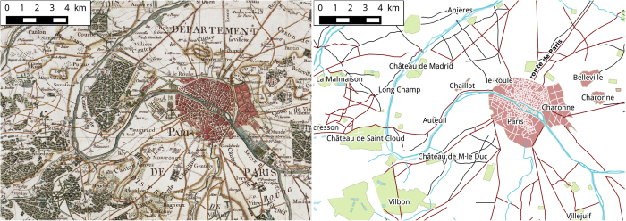
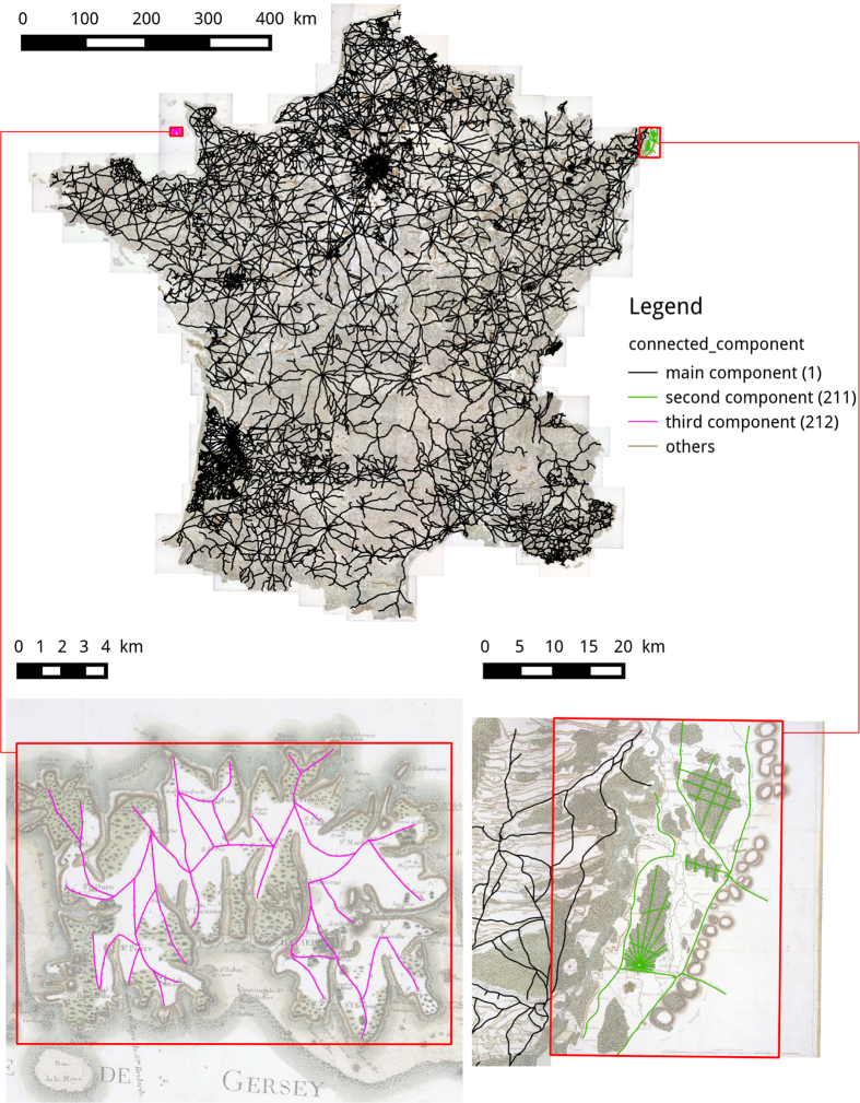
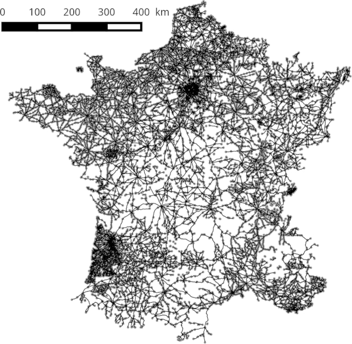
The evolution of infrastructure networks such as roads and streets are of utmost importance to understand the evolution of urban systems. However, datasets describing these spatial objects are rare and sparse. The database presented here represents the road network at the french national level described in the historical map of Cassini in the 18th century. The digitization of this historical map is based on a collaborative methodology that we describe in detail. This dataset can be used for a variety of interdisciplinary studies, covering multiple spatial resolutions and ranging from history, geography, urban economics to network science.

摘要

基础设施网络(如道路和街道)的演变对于理解城市系统的演变至关重要。然而,描述这些空间对象的数据集却很少且稀疏。本数据库呈现了 18 世纪卡塞尼历史地图中所描述的法国国家级道路网络。该历史地图的数字化采用了我们详细描述的合作方法。该数据集可用于各种跨学科研究,涵盖多个空间分辨率,从历史、地理、城市经济学到网络科学等领域。

https://cdn.ncbi.nlm.nih.gov/pmc/blobs/8875/4571106/14c567dc5bdb/sdata201548-f4.jpg
https://cdn.ncbi.nlm.nih.gov/pmc/blobs/8875/4571106/254d06eeb2f2/sdata201548-f1.jpg
https://cdn.ncbi.nlm.nih.gov/pmc/blobs/8875/4571106/bba5300b4742/sdata201548-f2.jpg
https://cdn.ncbi.nlm.nih.gov/pmc/blobs/8875/4571106/19f7f6e26448/sdata201548-f3.jpg
https://cdn.ncbi.nlm.nih.gov/pmc/blobs/8875/4571106/14c567dc5bdb/sdata201548-f4.jpg

相似文献

1
Roads and cities of 18th century France.18 世纪法国的道路与城市。
Sci Data. 2015 Sep 15;2:150048. doi: 10.1038/sdata.2015.48. eCollection 2015.
2
[The general planimetry of Madrid and the 18th-century city].[马德里及18世纪城市的总体平面测量]
Historias (Mex). 2001(48):83-98.
3
[Urban topography of estuarine port cities in modern France].[现代法国河口港口城市的城市地形]
Rekishigaku Kenkyu. 2001(12):24-35.
4
[The great urban axes of 18th-century Warsaw and the creativity of Andre Lenotre].[18世纪华沙的城市中轴线与安德烈·勒诺特尔的创造力]
Biul Hist Sztuki. 2001;63(1-4):43-76.
5
[Urban history and history of medicine: decompartmentalization and interdisciplinarity].[城市史与医学史:打破学科界限与跨学科研究]
Vesalius. 2012 Summer;18(1):12-5.
6
Limited urban growth: London's street network dynamics since the 18th century.城市发展的局限性:18 世纪以来伦敦街道网络的动态变化。
PLoS One. 2013 Aug 12;8(8):e69469. doi: 10.1371/journal.pone.0069469. eCollection 2013.
7
[Mobility in cities: revelatory of urban society?].[城市中的流动性:揭示城市社会?]
Ann Demogr Hist (Paris). 1999(1):7-15.
8
Towards the automated large-scale reconstruction of past road networks from historical maps.迈向从历史地图自动大规模重建过去的道路网络
Comput Environ Urban Syst. 2022 Jun;94. doi: 10.1016/j.compenvurbsys.2022.101794. Epub 2022 Mar 18.
9
[Orleans' hospital legacy].[奥尔良的医院遗产]
Rev Soc Fr Hist Hop. 2014 Jun(151):78-91.
10
A global map of travel time to cities to assess inequalities in accessibility in 2015.全球城市出行时间图评估 2015 年可达性的不平等。
Nature. 2018 Jan 18;553(7688):333-336. doi: 10.1038/nature25181. Epub 2018 Jan 10.

引用本文的文献

1
Epidemiology models explain rumour spreading during France's Great Fear of 1789.流行病学模型解释了1789年法国大革命恐惧时期谣言的传播。
Nature. 2025 Aug 27. doi: 10.1038/s41586-025-09392-2.
2
Creating a dataset of historic roads in Sydney from scanned maps.从扫描地图中创建悉尼历史道路数据集。
Sci Data. 2023 Oct 7;10(1):683. doi: 10.1038/s41597-023-02574-5.
3
Complex networks to understand the past: the case of roads in Bourbon Spain.理解过去的复杂网络:以波旁王朝时期西班牙的道路为例。

本文引用的文献

1
Limited urban growth: London's street network dynamics since the 18th century.城市发展的局限性:18 世纪以来伦敦街道网络的动态变化。
PLoS One. 2013 Aug 12;8(8):e69469. doi: 10.1371/journal.pone.0069469. eCollection 2013.
2
Self-organization versus top-down planning in the evolution of a city.城市演化中的自组织与自上而下的规划。
Sci Rep. 2013;3:2153. doi: 10.1038/srep02153.
3
Elementary processes governing the evolution of road networks.控制道路网络演化的基本过程。
Cliometrica (Berl). 2021;15(3):477-534. doi: 10.1007/s11698-020-00218-x. Epub 2020 Oct 6.
4
A protocol to convert spatial polyline data to network formats and applications to world urban road networks.将空间折线数据转换为网络格式的协议及在世界城市道路网络中的应用。
Sci Data. 2016 Jun 21;3:160046. doi: 10.1038/sdata.2016.46.
Sci Rep. 2012;2:296. doi: 10.1038/srep00296. Epub 2012 Mar 1.