Beckett Leah H, Baldwin Andrew H, Kearney Michael S
Marine-Estuarine-Environmental Sciences, University of Maryland, College Park, Maryland, United States of America.
Department of Environmental Science and Technology, University of Maryland, College Park, Maryland, United States of America.
PLoS One. 2016 Jul 28;11(7):e0159753. doi: 10.1371/journal.pone.0159753. eCollection 2016.
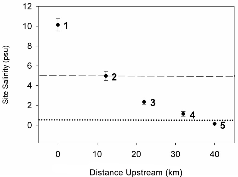
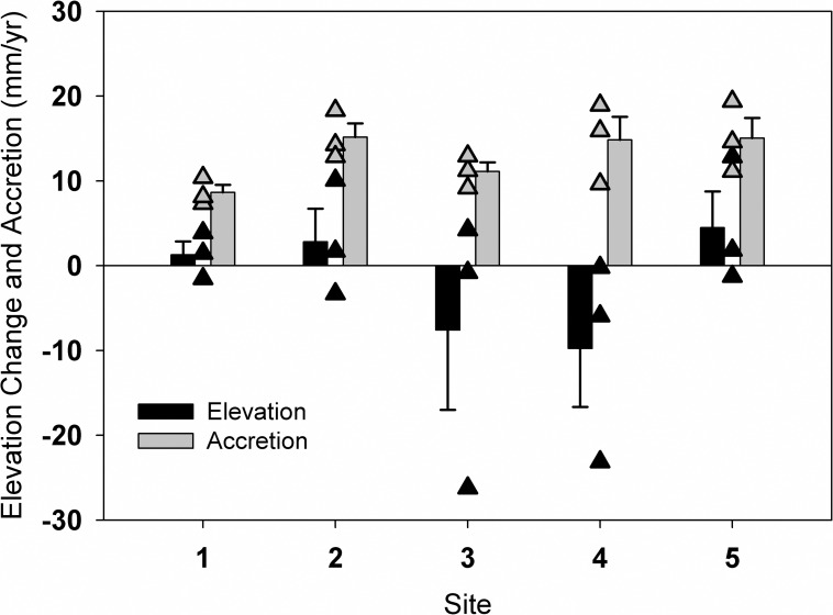
Sea-level rise is a major factor in wetland loss worldwide, and in much of Chesapeake Bay (USA) the rate of sea-level rise is higher than the current global rate of 3.2 mm yr-1 due to regional subsidence. Marshes along estuarine salinity gradients differ in vegetation composition, productivity, decomposition pathways, and sediment dynamics, and may exhibit different responses to sea-level rise. Coastal marshes persist by building vertically at rates at or exceeding regional sea-level rise. In one of the first studies to examine elevation dynamics across an estuarine salinity gradient, we installed 15 surface elevation tables (SET) and accretion marker-horizon plots (MH) in tidal freshwater, oligohaline, and brackish marshes across a Chesapeake Bay subestuary. Over the course of four years, wetlands across the subestuary decreased 1.8 ± 2.7 mm yr-1 in elevation on average, at least 5 mm yr-1 below that needed to keep pace with global sea-level rise. Elevation change rates did not significantly differ among the marshes studied, and ranged from -9.8 ± 6.9 to 4.5 ± 4.3 mm yr-1. Surface accretion of deposited mineral and organic matter was uniformly high across the estuary (~9-15 mm yr-1), indicating that elevation loss was not due to lack of accretionary input. Position in the estuary and associated salinity regime were not related to elevation change or surface matter accretion. Previous studies have focused on surface elevation change in marshes of uniform salinity (e.g., salt marshes); however, our findings highlight the need for elevation studies in marshes of all salinity regimes and different geomorphic positions, and warn that brackish, oligohaline, and freshwater tidal wetlands may be at similarly high risk of submergence in some estuaries.
海平面上升是全球湿地丧失的一个主要因素,在美国切萨皮克湾的大部分地区,由于区域沉降,海平面上升速率高于当前全球3.2毫米/年的速率。沿河口盐度梯度分布的沼泽地在植被组成、生产力、分解途径和沉积物动态方面存在差异,对海平面上升可能表现出不同的响应。沿海沼泽地通过以等于或超过区域海平面上升的速率进行垂直建造得以存续。在首批研究河口盐度梯度上高程动态变化的研究之一中,我们在切萨皮克湾一个子河口的潮汐淡水沼泽、低盐度沼泽和微咸水沼泽中安装了15个地表高程表(SET)和堆积标记地平线样地(MH)。在四年的时间里,整个子河口的湿地平均海拔下降了1.8±2.7毫米/年,至少比跟上全球海平面上升所需的速率低5毫米/年。在所研究的沼泽地中,高程变化率没有显著差异,范围在-9.8±6.9至4.5±4.3毫米/年之间。整个河口沉积的矿物和有机物质的地表堆积普遍较高(约9 - 15毫米/年),这表明高程损失并非由于缺乏堆积输入。在河口的位置及相关的盐度状况与高程变化或地表物质堆积无关。以往的研究主要集中在盐度均匀的沼泽地(如盐沼)的地表高程变化;然而,我们的研究结果凸显了对所有盐度状况和不同地貌位置的沼泽地进行高程研究的必要性,并警告说,在一些河口,微咸水、低盐度和淡水潮汐湿地可能面临同样高的淹没风险。