Töpel Mats, Zizka Alexander, Calió Maria Fernanda, Scharn Ruud, Silvestro Daniele, Antonelli Alexandre
Department of Marine Sciences, University of Gothenburg, PO Box 460, SE-405 30 Göteborg, Sweden.
Bioinformatics Infrastructure for Life Sciences.
Syst Biol. 2017 Mar 1;66(2):145-151. doi: 10.1093/sysbio/syw064.
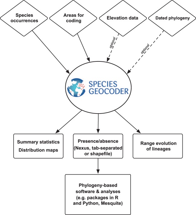
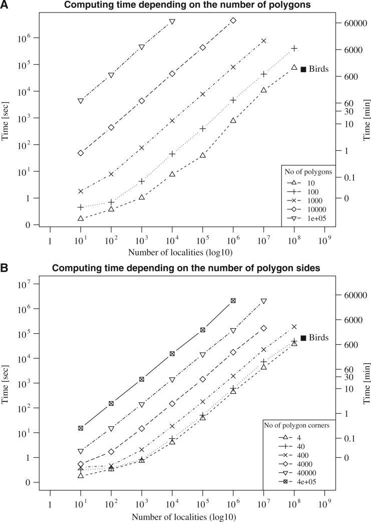
Understanding the patterns and processes underlying the uneven distribution of biodiversity across space constitutes a major scientific challenge in systematic biology and biogeography, which largely relies on effectively mapping and making sense of rapidly increasing species occurrence data. There is thus an urgent need for making the process of coding species into spatial units faster, automated, transparent, and reproducible. Here we present SpeciesGeoCoder, an open-source software package written in Python and R, that allows for easy coding of species into user-defined operational units. These units may be of any size and be purely spatial (i.e., polygons) such as countries and states, conservation areas, biomes, islands, biodiversity hotspots, and areas of endemism, but may also include elevation ranges. This flexibility allows scoring species into complex categories, such as those encountered in topographically and ecologically heterogeneous landscapes. In addition, SpeciesGeoCoder can be used to facilitate sorting and cleaning of occurrence data obtained from online databases, and for testing the impact of incorrect identification of specimens on the spatial coding of species. The various outputs of SpeciesGeoCoder include quantitative biodiversity statistics, global and local distribution maps, and files that can be used directly in many phylogeny-based applications for ancestral range reconstruction, investigations of biome evolution, and other comparative methods. Our simulations indicate that even datasets containing hundreds of millions of records can be analyzed in relatively short time using a standard computer. We exemplify the use of SpeciesGeoCoder by inferring the historical dispersal of birds across the Isthmus of Panama, showing that lowland species crossed the Isthmus about twice as frequently as montane species with a marked increase in the number of dispersals during the last 10 million years. [ancestral area reconstruction; biodiversity patterns; ecology; evolution; point in polygon; species distribution data.].
理解生物多样性在空间上分布不均背后的模式和过程,是系统生物学和生物地理学面临的一项重大科学挑战,这在很大程度上依赖于有效地绘制和理解快速增长的物种出现数据。因此,迫切需要使将物种编码到空间单元的过程更快、自动化、透明且可重复。在这里,我们展示了SpeciesGeoCoder,这是一个用Python和R编写的开源软件包,它允许轻松地将物种编码到用户定义的操作单元中。这些单元可以是任何大小,并且可以纯粹是空间性的(即多边形),例如国家和州、保护区、生物群落、岛屿、生物多样性热点和特有区域,但也可以包括海拔范围。这种灵活性允许将物种分类到复杂的类别中,例如在地形和生态异质景观中遇到的类别。此外,SpeciesGeoCoder可用于促进对从在线数据库获得的出现数据的分类和清理,并用于测试标本错误识别对物种空间编码的影响。SpeciesGeoCoder的各种输出包括定量生物多样性统计、全球和局部分布图,以及可直接用于许多基于系统发育的应用程序的文件,用于祖先分布范围重建、生物群落进化研究和其他比较方法。我们的模拟表明,即使是包含数亿条记录的数据集,使用标准计算机也可以在相对较短的时间内进行分析。我们通过推断鸟类在巴拿马地峡的历史扩散来举例说明SpeciesGeoCoder的使用,结果表明低地物种穿越地峡的频率大约是山地物种的两倍,在过去1000万年中扩散数量显著增加。[祖先分布区重建;生物多样性模式;生态学;进化;多边形内的点;物种分布数据。]