• 文献检索
  • 文档翻译
  • 深度研究
  • 学术资讯
  • Suppr Zotero 插件Zotero 插件
  • 邀请有礼
  • 套餐&价格
  • 历史记录
应用&插件
Suppr Zotero 插件Zotero 插件浏览器插件Mac 客户端Windows 客户端微信小程序
定价
高级版会员购买积分包购买API积分包
服务
文献检索文档翻译深度研究API 文档MCP 服务
关于我们
关于 Suppr公司介绍联系我们用户协议隐私条款
关注我们

Suppr 超能文献

核心技术专利:CN118964589B侵权必究
粤ICP备2023148730 号-1Suppr @ 2026

文献检索

告别复杂PubMed语法,用中文像聊天一样搜索,搜遍4000万医学文献。AI智能推荐,让科研检索更轻松。

立即免费搜索

文件翻译

保留排版,准确专业,支持PDF/Word/PPT等文件格式,支持 12+语言互译。

免费翻译文档

深度研究

AI帮你快速写综述,25分钟生成高质量综述,智能提取关键信息,辅助科研写作。

立即免费体验

一种基于激光雷达点云的森林垂直冠层结构分析及三维单木建模方法

A Lidar Point Cloud Based Procedure for Vertical Canopy Structure Analysis And 3D Single Tree Modelling in Forest.

作者信息

Wang Yunsheng, Weinacker Holger, Koch Barbara

机构信息

Dept. of Remote Sensing and Landscape Information Systems, University of Freiburg, Germany.

出版信息

Sensors (Basel). 2008 Jun 12;8(6):3938-3951. doi: 10.3390/s8063938.

DOI:10.3390/s8063938
PMID:27879916
原文链接:https://pmc.ncbi.nlm.nih.gov/articles/PMC3714669/
Abstract

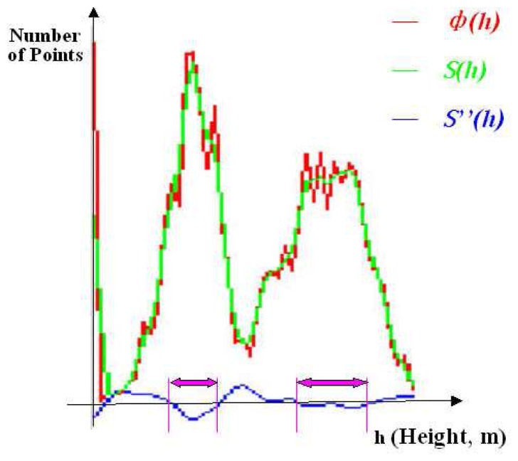
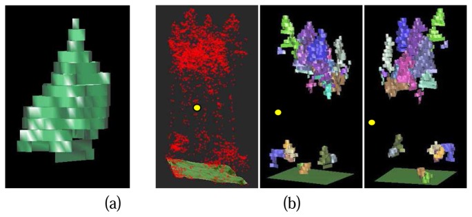
A procedure for both vertical canopy structure analysis and 3D single tree modelling based on Lidar point cloud is presented in this paper. The whole area of research is segmented into small study cells by a raster net. For each cell, a normalized point cloud whose point heights represent the absolute heights of the ground objects is generated from the original Lidar raw point cloud. The main tree canopy layers and the height ranges of the layers are detected according to a statistical analysis of the height distribution probability of the normalized raw points. For the 3D modelling of individual trees, individual trees are detected and delineated not only from the top canopy layer but also from the sub canopy layer. The normalized points are resampled into a local voxel space. A series of horizontal 2D projection images at the different height levels are then generated respect to the voxel space. Tree crown regions are detected from the projection images. Individual trees are then extracted by means of a pre-order forest traversal process through all the tree crown regions at the different height levels. Finally, 3D tree crown models of the extracted individual trees are reconstructed. With further analyses on the 3D models of individual tree crowns, important parameters such as crown height range, crown volume and crown contours at the different height levels can be derived.

摘要

本文提出了一种基于激光雷达点云的垂直冠层结构分析和三维单木建模方法。研究区域通过栅格网划分为小的研究单元。对于每个单元,从原始激光雷达原始点云中生成归一化点云,其点高度代表地面物体的绝对高度。根据归一化原始点高度分布概率的统计分析,检测主要树冠层及其高度范围。对于单木的三维建模,不仅从顶部树冠层,而且从亚树冠层检测和勾勒单木。将归一化点重新采样到局部体素空间。然后相对于体素空间生成不同高度水平的一系列水平二维投影图像。从投影图像中检测树冠区域。然后通过对不同高度水平的所有树冠区域进行前序森林遍历过程来提取单木。最后,重建提取的单木的三维树冠模型。通过对单木树冠三维模型的进一步分析,可以得出树冠高度范围、树冠体积和不同高度水平的树冠轮廓等重要参数。

https://cdn.ncbi.nlm.nih.gov/pmc/blobs/5b4c/3714669/26ae86dc4df4/sensors-08-03938f13.jpg
https://cdn.ncbi.nlm.nih.gov/pmc/blobs/5b4c/3714669/857073274591/sensors-08-03938f1.jpg
https://cdn.ncbi.nlm.nih.gov/pmc/blobs/5b4c/3714669/89fa7a826b23/sensors-08-03938f2.jpg
https://cdn.ncbi.nlm.nih.gov/pmc/blobs/5b4c/3714669/cb175d8dcd36/sensors-08-03938f3.jpg
https://cdn.ncbi.nlm.nih.gov/pmc/blobs/5b4c/3714669/82b6154febeb/sensors-08-03938f4.jpg
https://cdn.ncbi.nlm.nih.gov/pmc/blobs/5b4c/3714669/201b6fc5b319/sensors-08-03938f5.jpg
https://cdn.ncbi.nlm.nih.gov/pmc/blobs/5b4c/3714669/69caaacbfa43/sensors-08-03938f6.jpg
https://cdn.ncbi.nlm.nih.gov/pmc/blobs/5b4c/3714669/acd1ae798a77/sensors-08-03938f7.jpg
https://cdn.ncbi.nlm.nih.gov/pmc/blobs/5b4c/3714669/5063b997468d/sensors-08-03938f8.jpg
https://cdn.ncbi.nlm.nih.gov/pmc/blobs/5b4c/3714669/de4d83942416/sensors-08-03938f9.jpg
https://cdn.ncbi.nlm.nih.gov/pmc/blobs/5b4c/3714669/628812b855bf/sensors-08-03938f10.jpg
https://cdn.ncbi.nlm.nih.gov/pmc/blobs/5b4c/3714669/f927224b8523/sensors-08-03938f11.jpg
https://cdn.ncbi.nlm.nih.gov/pmc/blobs/5b4c/3714669/0d754dd0d278/sensors-08-03938f12.jpg
https://cdn.ncbi.nlm.nih.gov/pmc/blobs/5b4c/3714669/26ae86dc4df4/sensors-08-03938f13.jpg

相似文献

1
A Lidar Point Cloud Based Procedure for Vertical Canopy Structure Analysis And 3D Single Tree Modelling in Forest.一种基于激光雷达点云的森林垂直冠层结构分析及三维单木建模方法
Sensors (Basel). 2008 Jun 12;8(6):3938-3951. doi: 10.3390/s8063938.
2
Assessing and correcting topographic effects on forest canopy height retrieval using airborne LiDAR data.利用机载激光雷达数据评估和校正地形对森林冠层高度反演的影响。
Sensors (Basel). 2015 May 26;15(6):12133-55. doi: 10.3390/s150612133.
3
[An automatic extraction algorithm for individual tree crown projection area and volume based on 3D point cloud data].基于三维点云数据的单木树冠投影面积和体积自动提取算法
Guang Pu Xue Yu Guang Pu Fen Xi. 2014 Feb;34(2):465-71.
4
Mobile LiDAR Scanning System Combined with Canopy Morphology Extracting Methods for Tree Crown Parameters Evaluation in Orchards.用于果园树冠参数评估的移动激光雷达扫描系统与树冠形态提取方法的结合
Sensors (Basel). 2021 Jan 6;21(2):339. doi: 10.3390/s21020339.
5
Crown plasticity and competition for canopy space: a new spatially implicit model parameterized for 250 North American tree species.树冠可塑性和对冠层空间的竞争:为 250 种北美树种参数化的新的空间隐含模型。
PLoS One. 2007 Sep 12;2(9):e870. doi: 10.1371/journal.pone.0000870.
6
Tree parameter extraction in plantation based on airborne LiDAR data.基于机载 LiDAR 数据的人工林树木参数提取。
Ying Yong Sheng Tai Xue Bao. 2024 Feb;35(2):321-329. doi: 10.13287/j.1001-9332.202402.015.
7
Extracting Diameter at Breast Height with a Handheld Mobile LiDAR System in an Outdoor Environment.在户外环境中使用手持式移动激光雷达系统提取胸径
Sensors (Basel). 2019 Jul 21;19(14):3212. doi: 10.3390/s19143212.
8
Optimization and Evaluation of Sensor Angles for Precise Assessment of Architectural Traits in Peach Trees.优化和评估传感器角度,以精确评估桃树的建筑特征。
Sensors (Basel). 2022 Jun 18;22(12):4619. doi: 10.3390/s22124619.
9
Fine-Scale Quantification of Absorbed Photosynthetically Active Radiation (APAR) in Plantation Forests with 3D Radiative Transfer Modeling and LiDAR Data.利用三维辐射传输模型和激光雷达数据对人工林中光合有效辐射吸收量(APAR)进行精细尺度量化
Plant Phenomics. 2024 Apr 8;6:0166. doi: 10.34133/plantphenomics.0166. eCollection 2024.
10
[Estimating individual tree aboveground biomass of the mid-subtropical forest using airborne LiDAR technology].[利用机载激光雷达技术估算中亚热带森林单木地上生物量]
Ying Yong Sheng Tai Xue Bao. 2014 Nov;25(11):3229-36.

引用本文的文献

1
A Bottom-Up Multi-Feature Fusion Algorithm for Individual Tree Segmentation in Dense Rubber Tree Plantations Using Unmanned Aerial Vehicle-Light Detecting and Ranging.一种基于无人机激光雷达的密集橡胶园单株树木分割自下而上多特征融合算法
Plants (Basel). 2025 May 27;14(11):1640. doi: 10.3390/plants14111640.
2
Full-space Cloud of Random Points with a Scrambling Metasurface.具有扰频超表面的全空间随机点云
Light Sci Appl. 2018 Sep 12;7:63. doi: 10.1038/s41377-018-0064-3. eCollection 2018.
3
Measuring the dynamic photosynthome.测量动态光合体。
Ann Bot. 2018 Aug 1;122(2):207-220. doi: 10.1093/aob/mcy087.
4
Forest understory trees can be segmented accurately within sufficiently dense airborne laser scanning point clouds.林下地被树木可以在足够密集的机载激光扫描点云中被精确分割。
Sci Rep. 2017 Jul 28;7(1):6770. doi: 10.1038/s41598-017-07200-0.
5
Rapid characterization of vegetation structure with a Microsoft Kinect sensor.利用微软 Kinect 传感器快速描述植被结构。
Sensors (Basel). 2013 Feb 11;13(2):2384-98. doi: 10.3390/s130202384.
6
Vehicle based laser range finding in crops.车载激光作物测距。
Sensors (Basel). 2009;9(5):3679-94. doi: 10.3390/s90503679. Epub 2009 May 15.
7
The use of airborne laser scanning to develop a pixel-based stratification for a verified carbon offset project.利用机载激光扫描技术为经核实的碳补偿项目开发基于像素的分层。
Carbon Balance Manag. 2011 Oct 17;6:9. doi: 10.1186/1750-0680-6-9.