• 文献检索
  • 文档翻译
  • 深度研究
  • 学术资讯
  • Suppr Zotero 插件Zotero 插件
  • 邀请有礼
  • 套餐&价格
  • 历史记录
应用&插件
Suppr Zotero 插件Zotero 插件浏览器插件Mac 客户端Windows 客户端微信小程序
定价
高级版会员购买积分包购买API积分包
服务
文献检索文档翻译深度研究API 文档MCP 服务
关于我们
关于 Suppr公司介绍联系我们用户协议隐私条款
关注我们

Suppr 超能文献

核心技术专利:CN118964589B侵权必究
粤ICP备2023148730 号-1Suppr @ 2026

文献检索

告别复杂PubMed语法,用中文像聊天一样搜索,搜遍4000万医学文献。AI智能推荐,让科研检索更轻松。

立即免费搜索

文件翻译

保留排版,准确专业,支持PDF/Word/PPT等文件格式,支持 12+语言互译。

免费翻译文档

深度研究

AI帮你快速写综述,25分钟生成高质量综述,智能提取关键信息,辅助科研写作。

立即免费体验

全球分布式流域形态计量数据集。

A global distributed basin morphometric dataset.

机构信息

Department of Civil &Environmental Engineering, University of Connecticut, Storrs, Connecticut 06269-3037, USA.

Advanced Radar Research Center, National Weather Center, University of Oklahoma, Norman, Oklahoma 73072, USA.

出版信息

Sci Data. 2017 Jan 5;4:160124. doi: 10.1038/sdata.2016.124.

DOI:10.1038/sdata.2016.124
PMID:28055032
原文链接:https://pmc.ncbi.nlm.nih.gov/articles/PMC5216664/
Abstract

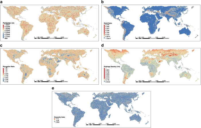
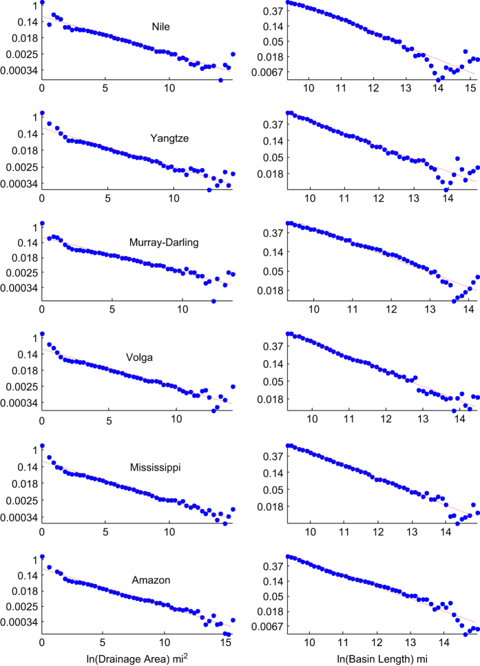
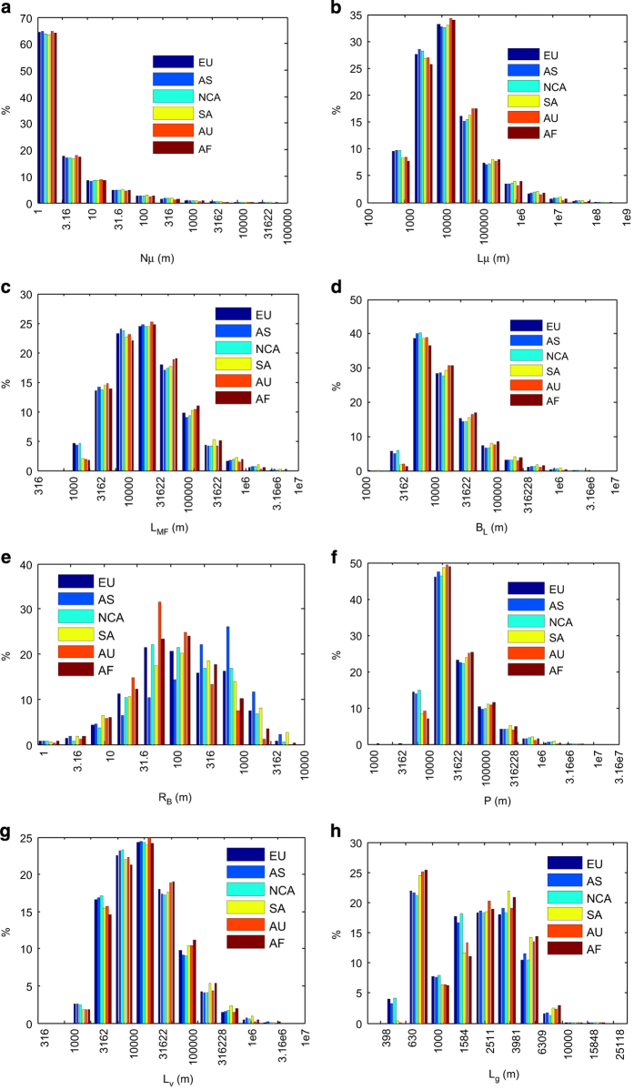
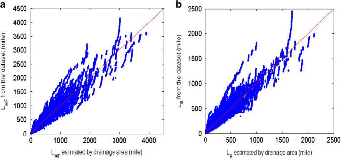
Basin morphometry is vital information for relating storms to hydrologic hazards, such as landslides and floods. In this paper we present the first comprehensive global dataset of distributed basin morphometry at 30 arc seconds resolution. The dataset includes nine prime morphometric variables; in addition we present formulas for generating twenty-one additional morphometric variables based on combination of the prime variables. The dataset can aid different applications including studies of land-atmosphere interaction, and modelling of floods and droughts for sustainable water management. The validity of the dataset has been consolidated by successfully repeating the Hack's law.

摘要

流域形态计量学是将风暴与水文灾害(如滑坡和洪水)联系起来的重要信息。在本文中,我们提出了第一个具有 30 弧秒分辨率的分布式流域形态计量学的全球综合数据集。该数据集包括九个主要形态计量变量;此外,我们还提出了基于主要变量组合生成二十一个附加形态计量变量的公式。该数据集可辅助不同的应用,包括土地-大气相互作用的研究,以及洪水和干旱模型,以实现可持续水资源管理。该数据集的有效性已通过成功重复哈克定律得到巩固。

https://cdn.ncbi.nlm.nih.gov/pmc/blobs/759f/5216664/fe7b4bd09ed7/sdata2016124-f4.jpg
https://cdn.ncbi.nlm.nih.gov/pmc/blobs/759f/5216664/6b67235c54d6/sdata2016124-f1.jpg
https://cdn.ncbi.nlm.nih.gov/pmc/blobs/759f/5216664/86d8aaeb711a/sdata2016124-f2.jpg
https://cdn.ncbi.nlm.nih.gov/pmc/blobs/759f/5216664/1436c13ce582/sdata2016124-f3.jpg
https://cdn.ncbi.nlm.nih.gov/pmc/blobs/759f/5216664/fe7b4bd09ed7/sdata2016124-f4.jpg

相似文献

1
A global distributed basin morphometric dataset.全球分布式流域形态计量数据集。
Sci Data. 2017 Jan 5;4:160124. doi: 10.1038/sdata.2016.124.
2
When trends intersect: The challenge of protecting freshwater ecosystems under multiple land use and hydrological intensification scenarios.当趋势交汇时:在多种土地利用和水文强化情景下保护淡水生态系统面临的挑战。
Sci Total Environ. 2015 Nov 15;534:65-78. doi: 10.1016/j.scitotenv.2015.03.127. Epub 2015 Apr 10.
3
Impacts of climate change on precipitation and discharge extremes through the use of statistical downscaling approaches in a Mediterranean basin.利用统计降尺度方法在一个地中海流域评估气候变化对降水和径流极值的影响。
Sci Total Environ. 2016 Feb 1;543(Pt B):952-64. doi: 10.1016/j.scitotenv.2015.06.088. Epub 2015 Jul 3.
4
The shape of watersheds.流域的形状。
Nat Commun. 2018 Sep 17;9(1):3791. doi: 10.1038/s41467-018-06210-4.
5
Development of a regional hydrologic soil model and application to the Beerze--Reusel drainage basin.区域水文土壤模型的开发及其在贝泽-勒塞尔流域的应用。
Environ Pollut. 2007 Aug;148(3):855-66. doi: 10.1016/j.envpol.2007.01.046. Epub 2007 May 2.
6
Assessing irrigated agriculture's surface water and groundwater consumption by combining satellite remote sensing and hydrologic modelling.结合卫星遥感和水文模型评估灌溉农业的地表水和地下水消耗。
Sci Total Environ. 2016 Jan 15;542(Pt A):372-82. doi: 10.1016/j.scitotenv.2015.10.086. Epub 2015 Nov 3.
7
Hazard analysis of Arid and semi-Arid (ASAL) regions of Kenya.肯尼亚干旱和半干旱地区的风险分析。
East Afr J Public Health. 2013 Jun;10(2):410-5.
8
Landscape changes as a factor affecting the course and consequences of extreme floods in the Otava river basin, Czech Republic.景观变化作为影响捷克共和国奥塔瓦河流域极端洪水过程及后果的一个因素。
Environ Monit Assess. 2008 Sep;144(1-3):53-66. doi: 10.1007/s10661-007-9941-6. Epub 2007 Sep 21.
9
Building human resilience: the role of public health preparedness and response as an adaptation to climate change.增强人类适应能力:公共卫生防范与应对作为适应气候变化的作用。
Am J Prev Med. 2008 Nov;35(5):508-16. doi: 10.1016/j.amepre.2008.08.022.
10
Integrated assessment of policy interventions for promoting sustainable irrigation in semi-arid environments: a hydro-economic modeling approach.半干旱环境下促进可持续灌溉的政策干预综合评估:一种水经济建模方法。
J Environ Manage. 2013 Oct 15;128:144-60. doi: 10.1016/j.jenvman.2013.04.037. Epub 2013 Jun 1.

引用本文的文献

1
Impact of LULC changes on small watershed morphometry and delineation of sustainable conservation strategies for degraded transboundary rivers.土地利用与土地覆盖变化对小流域形态测量的影响以及退化跨境河流可持续保护策略的划定
Sci Rep. 2025 Jul 5;15(1):24063. doi: 10.1038/s41598-025-08841-2.
2
GDBM: A database of global drainage basin morphology.GDBM:全球流域形态数据库。
PLoS One. 2025 Apr 7;20(4):e0320771. doi: 10.1371/journal.pone.0320771. eCollection 2025.
3
National-scale geodatabase of catchment characteristics in the Philippines for river management applications.

本文引用的文献

1
Scaling laws for river networks.河网的标度律。
Phys Rev E Stat Phys Plasmas Fluids Relat Interdiscip Topics. 1996 Feb;53(2):1510-1515. doi: 10.1103/physreve.53.1510.
菲律宾流域特征国家规模地理数据库,用于河流管理应用。
PLoS One. 2023 Mar 8;18(3):e0281933. doi: 10.1371/journal.pone.0281933. eCollection 2023.
4
Drainage network position and historical connectivity explain global patterns in freshwater fishes' range size.排水管网位置和历史连通性解释了全球淡水鱼类分布范围大小的模式。
Proc Natl Acad Sci U S A. 2019 Jul 2;116(27):13434-13439. doi: 10.1073/pnas.1902484116. Epub 2019 Jun 17.
5
GFPLAIN250m, a global high-resolution dataset of Earth's floodplains.GFPLAIN250m,一个全球高分辨率的地球洪泛平原数据集。
Sci Data. 2019 Jan 15;6:180309. doi: 10.1038/sdata.2018.309.
6
The shape of watersheds.流域的形状。
Nat Commun. 2018 Sep 17;9(1):3791. doi: 10.1038/s41467-018-06210-4.