Department of Geography, National University of Singapore, 117570, Singapore.
Earth Observatory of Singapore Nanyang Technological University Singapore, 639798, Singapore.
Sci Rep. 2017 Mar 9;7:43742. doi: 10.1038/srep43742.
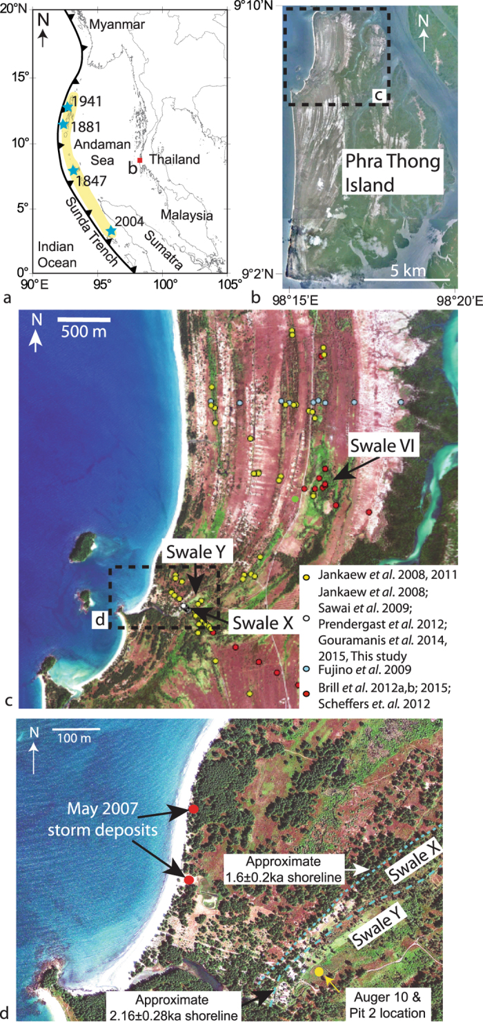
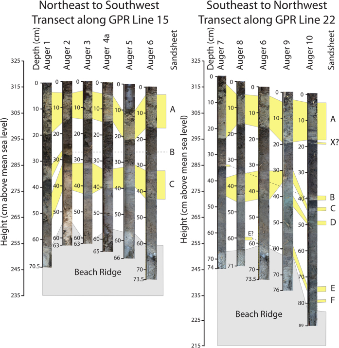
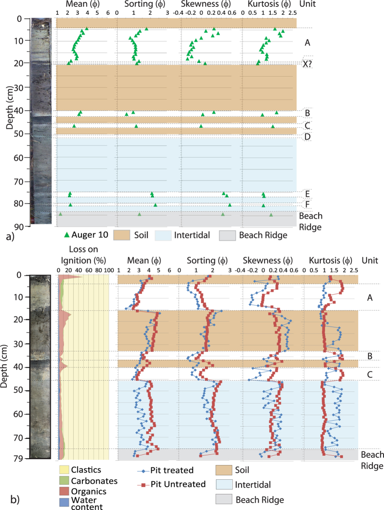
The 26 December 2004 Indian Ocean Tsunami (IOT) emanated from an Mw 9.2 earthquake that generated a 1600 km-long rupture along the Sumatran Megathrust and generated tsunami waves up to 30 m high. The IOT directly impacted the Bay of Bengal and east Africa, with over 283,000 people perishing. At the time, this catastrophic event was considered unprecedented and sparked intense investigations to test this claim. It is now believed that four pre-2004 IOT events have occurred in the last 2500 years, recurring every 550 to 700 years. Much of this information comes from Phra Thong Island, Thailand, where a sequence of four stacked sandsheets separated by organic units has been recognised and compared to the 2004 IOT event. Recently, ground-penetrating radar on Phra Thong Island identified a region that could not be explained by the known stratigraphy. The stratigraphy of the area was investigated from auger cores and pits, and several previously-unrecognised sandsheets were identified and compared to the known tsunami sandsheets. The proximity of the newly-recognised sandsheets to the palaeo-coastline of Phra Thong Island does not preclude the impacts of localised storms in sandsheet emplacement or that tsunamigenic earthquake recurrence may have been more frequent in the past.
2004 年 12 月 26 日印度洋海啸(IOT)源自Mw9.2 级地震,该地震沿苏门答腊巨俯冲带引发了长达 1600 公里的破裂,并产生了高达 30 米的海啸波。IOT 直接冲击了孟加拉湾和东非,导致超过 283000 人死亡。当时,这一灾难性事件被认为是前所未有的,并引发了激烈的调查,以验证这一说法。现在人们相信,在过去的 2500 年中,已经发生了四次发生在 2004 年之前的 IOT 事件,每 550 到 700 年重复一次。这些信息大多来自泰国的 Phra Thong 岛,那里已经识别出并与 2004 年 IOT 事件相对比的是由四个堆叠的沙层组成的序列,这些沙层由有机单元隔开。最近,Phra Thong 岛上的探地雷达在已知地层中识别出了一个无法解释的区域。对该地区的地层结构进行了研究,包括使用螺旋钻取芯和坑钻取芯,并识别出了几个以前未被识别的沙层,并将其与已知的海啸沙层进行了比较。新识别出的沙层与 Phra Thong 岛古海岸线的接近性并不排除局部风暴在沙层沉积中的影响,也不能排除过去震源复发可能更频繁的情况。