• 文献检索
  • 文档翻译
  • 深度研究
  • 学术资讯
  • Suppr Zotero 插件Zotero 插件
  • 邀请有礼
  • 套餐&价格
  • 历史记录
应用&插件
Suppr Zotero 插件Zotero 插件浏览器插件Mac 客户端Windows 客户端微信小程序
定价
高级版会员购买积分包购买API积分包
服务
文献检索文档翻译深度研究API 文档MCP 服务
关于我们
关于 Suppr公司介绍联系我们用户协议隐私条款
关注我们

Suppr 超能文献

核心技术专利:CN118964589B侵权必究
粤ICP备2023148730 号-1Suppr @ 2026

文献检索

告别复杂PubMed语法,用中文像聊天一样搜索,搜遍4000万医学文献。AI智能推荐,让科研检索更轻松。

立即免费搜索

文件翻译

保留排版,准确专业,支持PDF/Word/PPT等文件格式,支持 12+语言互译。

免费翻译文档

深度研究

AI帮你快速写综述,25分钟生成高质量综述,智能提取关键信息,辅助科研写作。

立即免费体验

基于传感器星座的车载点云与全景图像配准

Registration of Vehicle-Borne Point Clouds and Panoramic Images Based on Sensor Constellations.

作者信息

Yao Lianbi, Wu Hangbin, Li Yayun, Meng Bin, Qian Jinfei, Liu Chun, Fan Hongchao

机构信息

College of Surveying and Geoinformatics, Tongji University, Shanghai 200092, China.

Institute of Geography, Heidelberg University, Heidelberg D-69120, Germany.

出版信息

Sensors (Basel). 2017 Apr 11;17(4):837. doi: 10.3390/s17040837.

DOI:10.3390/s17040837
PMID:28398256
原文链接:https://pmc.ncbi.nlm.nih.gov/articles/PMC5422198/
Abstract

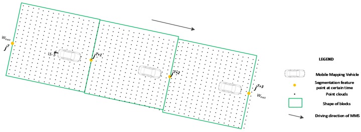
A mobile mapping system (MMS) is usually utilized to collect environmental data on and around urban roads. Laser scanners and panoramic cameras are the main sensors of an MMS. This paper presents a new method for the registration of the point clouds and panoramic images based on sensor constellation. After the sensor constellation was analyzed, a feature point, the intersection of the connecting line between the global positioning system (GPS) antenna and the panoramic camera with a horizontal plane, was utilized to separate the point clouds into blocks. The blocks for the central and sideward laser scanners were extracted with the segmentation feature points. Then, the point clouds located in the blocks were separated from the original point clouds. Each point in the blocks was used to find the accurate corresponding pixel in the relative panoramic images via a collinear function, and the position and orientation relationship amongst different sensors. A search strategy is proposed for the correspondence of laser scanners and lenses of panoramic cameras to reduce calculation complexity and improve efficiency. Four cases of different urban road types were selected to verify the efficiency and accuracy of the proposed method. Results indicate that most of the point clouds (with an average of 99.7%) were successfully registered with the panoramic images with great efficiency. Geometric evaluation results indicate that horizontal accuracy was approximately 0.10-0.20 m, and vertical accuracy was approximately 0.01-0.02 m for all cases. Finally, the main factors that affect registration accuracy, including time synchronization amongst different sensors, system positioning and vehicle speed, are discussed.

摘要

移动测绘系统(MMS)通常用于收集城市道路及其周边的环境数据。激光扫描仪和全景相机是MMS的主要传感器。本文提出了一种基于传感器星座的点云与全景图像配准新方法。在分析传感器星座后,利用一个特征点(全球定位系统(GPS)天线与全景相机之间连接线与水平面的交点)将点云分割成块。利用分割特征点提取中央和侧向激光扫描仪的块。然后,将位于这些块中的点云从原始点云中分离出来。通过共线函数以及不同传感器之间的位置和方向关系,利用块中的每个点在相对的全景图像中找到准确对应的像素。提出了一种用于激光扫描仪与全景相机镜头对应关系的搜索策略,以降低计算复杂度并提高效率。选择了四种不同城市道路类型的案例来验证所提方法的效率和准确性。结果表明,大部分点云(平均99.7%)都能高效地与全景图像成功配准。几何评估结果表明,所有案例的水平精度约为0.10 - 0.20米,垂直精度约为0.01 - 0.02米。最后,讨论了影响配准精度的主要因素,包括不同传感器之间的时间同步、系统定位和车速。

https://cdn.ncbi.nlm.nih.gov/pmc/blobs/73f1/5422198/8853d7717656/sensors-17-00837-g011.jpg
https://cdn.ncbi.nlm.nih.gov/pmc/blobs/73f1/5422198/65ec5af701b5/sensors-17-00837-g001.jpg
https://cdn.ncbi.nlm.nih.gov/pmc/blobs/73f1/5422198/bcbcbb5b5365/sensors-17-00837-g002.jpg
https://cdn.ncbi.nlm.nih.gov/pmc/blobs/73f1/5422198/638477f42636/sensors-17-00837-g003.jpg
https://cdn.ncbi.nlm.nih.gov/pmc/blobs/73f1/5422198/e613debcc799/sensors-17-00837-g004.jpg
https://cdn.ncbi.nlm.nih.gov/pmc/blobs/73f1/5422198/d20983aa066d/sensors-17-00837-g005.jpg
https://cdn.ncbi.nlm.nih.gov/pmc/blobs/73f1/5422198/ddacf335df90/sensors-17-00837-g006.jpg
https://cdn.ncbi.nlm.nih.gov/pmc/blobs/73f1/5422198/84b22b847401/sensors-17-00837-g007.jpg
https://cdn.ncbi.nlm.nih.gov/pmc/blobs/73f1/5422198/cad6ae8f8fa9/sensors-17-00837-g008.jpg
https://cdn.ncbi.nlm.nih.gov/pmc/blobs/73f1/5422198/0bf25ff38f0f/sensors-17-00837-g009.jpg
https://cdn.ncbi.nlm.nih.gov/pmc/blobs/73f1/5422198/f8fa14096be6/sensors-17-00837-g010.jpg
https://cdn.ncbi.nlm.nih.gov/pmc/blobs/73f1/5422198/8853d7717656/sensors-17-00837-g011.jpg

相似文献

1
Registration of Vehicle-Borne Point Clouds and Panoramic Images Based on Sensor Constellations.基于传感器星座的车载点云与全景图像配准
Sensors (Basel). 2017 Apr 11;17(4):837. doi: 10.3390/s17040837.
2
Line-Based Registration of Panoramic Images and LiDAR Point Clouds for Mobile Mapping.用于移动测绘的全景图像与激光雷达点云的基于线的配准
Sensors (Basel). 2016 Dec 31;17(1):70. doi: 10.3390/s17010070.
3
Registration of Panoramic/Fish-Eye Image Sequence and LiDAR Points Using Skyline Features.基于天际线特征的全景/鱼眼图像序列与 LiDAR 点注册。
Sensors (Basel). 2018 May 21;18(5):1651. doi: 10.3390/s18051651.
4
Automatic Registration of Terrestrial Laser Scanning Point Clouds using Panoramic Reflectance Images.基于全景反射图像的地面激光扫描点云自动配准
Sensors (Basel). 2009;9(4):2621-46. doi: 10.3390/s90402621. Epub 2009 Apr 15.
5
Automatic Registration of TLS-TLS and TLS-MLS Point Clouds Using a Genetic Algorithm.使用遗传算法对TLS-TLS和TLS-MLS点云进行自动配准
Sensors (Basel). 2017 Aug 29;17(9):1979. doi: 10.3390/s17091979.
6
Entropy-Based Registration of Point Clouds Using Terrestrial Laser Scanning and Smartphone GPS.基于熵的点云配准:利用地面激光扫描和智能手机全球定位系统
Sensors (Basel). 2017 Jan 20;17(1):197. doi: 10.3390/s17010197.
7
Outdoor Scene Understanding Based on Multi-Scale PBA Image Features and Point Cloud Features.基于多尺度 PBA 图像特征和点云特征的户外场景理解。
Sensors (Basel). 2019 Oct 19;19(20):4546. doi: 10.3390/s19204546.
8
Scan Line Based Road Marking Extraction from Mobile LiDAR Point Clouds.基于扫描线的移动激光雷达点云道路标线提取
Sensors (Basel). 2016 Jun 17;16(6):903. doi: 10.3390/s16060903.
9
Vertical Optical Scanning with Panoramic Vision for Tree Trunk Reconstruction.用于树干重建的具有全景视觉的垂直光学扫描
Sensors (Basel). 2017 Dec 2;17(12):2791. doi: 10.3390/s17122791.
10
Development of Mobile Mapping System for 3D Road Asset Inventory.用于三维道路资产清查的移动测绘系统的开发。
Sensors (Basel). 2016 Mar 12;16(3):367. doi: 10.3390/s16030367.

引用本文的文献

1
Cost Effective Mobile Mapping System for Color Point Cloud Reconstruction.用于彩色点云重建的经济高效移动测绘系统
Sensors (Basel). 2020 Nov 16;20(22):6536. doi: 10.3390/s20226536.

本文引用的文献

1
Line-Based Registration of Panoramic Images and LiDAR Point Clouds for Mobile Mapping.用于移动测绘的全景图像与激光雷达点云的基于线的配准
Sensors (Basel). 2016 Dec 31;17(1):70. doi: 10.3390/s17010070.
2
Mapping real-time air pollution health risk for environmental management: Combining mobile and stationary air pollution monitoring with neural network models.为环境管理绘制实时空气污染健康风险图:将移动和固定空气污染监测与神经网络模型相结合。
J Environ Manage. 2016 Mar 1;168:133-41. doi: 10.1016/j.jenvman.2015.12.012. Epub 2015 Dec 17.